Five Springs Falls Lower Campground Campground
Community Reviews
Been here? Share the conditions.
Reviews, ratings & photos are added in the free Snoflo iOS app — rate a spot, tag the conditions, and your visit is verified by location. Add or manage your reviews from the app.
Five Springs Falls Lower Campground
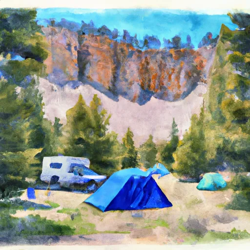
The campground offers a range of amenities to campers, including 15 campsites, picnic tables, fire rings, vault toilets, and potable water. There is also a nearby trailhead for hikers and mountain bikers looking to explore the surrounding area. The campground is open from June through September, with peak season being in July and August.
One interesting fact about the area is that it was once home to the Crow Nation, who used the nearby springs for their water source. The springs are still visible today and are a popular spot for visitors to the area.
The best time of year to visit Five Springs Falls Lower Campground is during the summer months, when the average temperature ranges from the mid-70s to low 80s Fahrenheit during the day and drops to the mid-40s at night. This mild weather makes for comfortable camping and hiking conditions.
Overall, Five Springs Falls Lower Campground is a beautiful and serene camping area that offers stunning views, easy access to nearby points of interest, and a range of amenities to make your stay enjoyable.
What's on-site at Five Springs Falls Lower Campground
Key facilities Snoflo tracks for this campground. Confirm with the operator before booking -- amenities can change seasonally.
Plan your trip down to the hour
Same weather feed Snoflo's iOS app uses -- updated continuously from NOAA / yr.no.
Next 5 days, hour by hour
Temperature line with weather symbols on top, snow + rain accumulation as columns, humidity as a dotted line.
5-day forecast table
Every 3 hours, broken out across temperature, snow, rain, humidity, and wind. Each cell is colour-coded relative to the column min/max so trends jump out at a glance.
| Time | Condition | Temp (°F) | Snow (in) | Rain (in) | Humidity (%) | Wind (mps) | Wind dir |
|---|---|---|---|---|---|---|---|
| Loading detailed forecast… | |||||||
15-day temperature & precipitation
Daily temperatures, snow, and rain projected over the next two weeks. Hover any point for the full breakdown.
Other campgrounds in the area
Snoflo-tracked campsites within driving distance of Five Springs Falls Lower Campground, with reservations status.
| Campground | Reservations | Toilets | View |
|---|---|---|---|
| Five Springs Falls Lower Host Campsite | ✗ | ✗ | → |
| Five Springs Falls | ✗ | ✓ | → |
| Five Springs Falls Lower Campsite 1 | ✗ | ✗ | → |
| Five Springs Falls Lower Campsite 2 | ✗ | ✗ | → |
| Five Springs Falls Lower Campsite 3 | ✗ | ✗ | → |
Nearby streamflow
USGS streamgauges within reach of Five Springs Falls Lower Campground -- pulled live from the National Water Information System.
| Streamgauge | Discharge | View |
|---|---|---|
| Bighorn River At Kane | 782 cfs | → |
| Shell Creek Near Shell | 74 cfs | → |
| Little Bighorn River At State Line Nr Wyola Mt | 89 cfs | → |
| Shoshone River Near Lovell | 663 cfs | → |
| West Pass Creek Near Parkman | 10 cfs | → |
| Bighorn River At Basin | 677 cfs | → |
Nearby snow depths
NRCS SNOTEL stations within reach of Five Springs Falls Lower Campground -- relevant when planning a shoulder-season or alpine trip.
| SNOTEL station | Snowpack | 24h Snowfall | View |
|---|---|---|---|
| Nohrsc Bald Mountain Snotel | 0.0 in | 0.0 in | → |
| Bald Mtn. | 0.0 in | 0.0 in | → |
| Nohrsc Bone Springs Divide Snotel | 0.0 in | 0.0 in | → |
| Bone Springs Div | 0.0 in | 0.0 in | → |
| Nohrsc Burgess Junction | 0.0 in | 0.0 in | → |
| Burgess Junction | 0.0 in | 0.0 in | → |
Plan a longer trip
The closest parks, lakes, boat launches, and paddle runs so a camping night can grow into a full weekend.
Parks
Boat launches
Fishing spots
- Big Horn Lake
- Tongue River Fishing West
- Tongue River Fishing East
- Tongue River Fishing Site
- Bighorn Lake
- Upper Paintrock Fishing Site
Camping essentials & Leave No Trace
- Pack it in, pack it out
- Take all trash, food scraps, and gear back with you to keep campsites clean and protect wildlife.
- Respect wildlife
- Observe animals from a distance, store food securely, and never feed wildlife to maintain natural behavior and safety.
- Know before you go
- Check weather, fire restrictions, trail conditions, and permit requirements to ensure a safe and well-planned trip.
- Minimize campfire impact
- Use established fire rings, keep fires small, fully extinguish them, or opt for a camp stove when fires are restricted.
- Leave what you find
- Preserve natural and cultural features by avoiding removal of plants, rocks, artifacts, or other elements of the environment.
Set push alerts in the Snoflo app
Save Five Springs Falls Lower Campground as a favorite, set a custom threshold (precipitation, snowpack, freezing temperatures), and the iOS app will push the moment conditions cross.
About Five Springs Falls Lower Campground
Can I make reservations at Five Springs Falls Lower Campground?
This campground does not appear to accept reservations -- it's typically first-come, first-served. Arrive early on summer weekends.
How fresh is the weather data on this page?
The hourly forecast updates throughout the day from the NOAA / yr.no public feeds. Streamflow data is pulled live from USGS streamgauges and snowpack from the NRCS SNOTEL network.
What's the best time of year to visit?
Use the 15-day temperature & precipitation outlook on this page to plan -- pick a window with comfortable temperatures and low precipitation. For longer trips, the 5-day hourly meteogram shows snow + rain accumulation hour-by-hour.
How do I get to Five Springs Falls Lower Campground?
Tap Directions in the hero above to open driving directions in Google Maps, or Open in map to center the Snoflo interactive map on the campground.
Can I get alerts when conditions change?
Yes -- alerts are managed through the Snoflo iOS app. Favorite this campground, set a threshold (temperature, snowpack, precipitation), and you'll get a push the moment it crosses.
Other campgrounds near here
Snoflo-tracked campgrounds within driving distance of Five Springs Falls Lower Campground.