Timberline-Lodge

Climate Recreation Community Catastrophe

Timberline-Lodge
Eden Index

Climate 5.5 Recreation 5.4 Community Safeguard

4.1/10

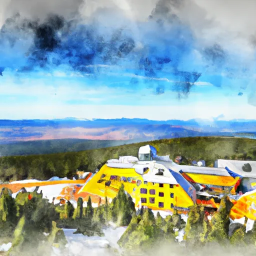
Timberline Lodge is a historic mountain retreat located on the south side of Mount Hood in Oregon, USA. Situated at an elevation of 6,000 feet, the lodge offers a unique alpine experience and breathtaking views of the surrounding Cascade Range. The climate at Timberline Lodge is characterized by mild summers and snowy winters. Average temperatures range from the mid-70s Fahrenheit in summer to the mid-20s in winter, making it an ideal destination for outdoor enthusiasts year-round.

Hydrologically, Timberline Lodge benefits from the abundant snowfall that blankets Mount Hood during winter months. This snowpack provides a vital water source for rivers, streams, and lakes downstream during the drier months. The lodge is located near the headwaters of the Salmon River and the Sandy River, which are popular for fishing and other water-based activities.

Outdoor recreation opportunities are plentiful at Timberline Lodge. In winter, visitors can enjoy skiing and snowboarding on the slopes of Mount Hood. The lodge operates the only year-round ski resort in North America, offering skiing even in the summer months. In addition to skiing, hiking, backpacking, mountain biking, and wildlife viewing opportunities abound during the warmer months, attracting outdoor enthusiasts from across the region. Overall, Timberline Lodge offers a unique combination of natural beauty, recreational activities, and historic charm that attracts visitors throughout the year.

What is the Eden Index?

The Snoflo Eden Index serves as a comprehensive rating system for regions, evaluating their desirability through a holistic assessment of climate health, outdoor recreation opportunities, and natural disaster risk, acknowledging the profound impact of these factors on livability and well-being.


Climate Health Indicator (CHI): 5.5


Timberline-Lodge receives approximately 2219mm of rain per year, with humidity levels near 68% and air temperatures averaging around 6°C. Timberline-Lodge has a plant hardyness factor of 7, meaning plants and agriculture in this region tend to thrive during the non-winter months. By considering the ideal temperature range, reliable water supplies, clean air, and stable seasonal rain or snowpacks, the Climate Health Indicator (CHI) underscores the significance of a healthy climate as the foundation for quality living.

A healthy climate is paramount for ensuring a high quality of life and livability in a region, fostering both physical well-being and environmental harmony. This can be characterized by ideal temperatures, reliable access to water supplies, clean air, and consistent seasonal rain or snowpacks.


Weather Forecast


Streamflow Conditions

Lower Columbia

Area Rivers

Lower Columbia


Snowpack Depths

Lower Columbia


Reservoir Storage Capacity

Lower Columbia


Groundwater Levels


Recreational Opportunity Index (ROI): 5.4


The Recreational Opportunity Index (ROI) recognizes the value of outdoor recreational options, such as parks, hiking trails, camping sites, and fishing spots, while acknowledging that climate plays a pivotal role in ensuring the comfort and consistency of these experiences. Access to outdoor recreational opportunities, encompassing activities such as parks, hiking, camping, and fishing, is crucial for overall well-being, and the climate plays a pivotal role in enabling and enhancing these experiences, ensuring that individuals can engage in nature-based activities comfortably and consistently.


Camping Areas

Campground Campsites Reservations Toilets Showers Elevation
McNeil 34 2,052 ft
Wahtum Lake 8 3,953 ft
Routson None 2,463 ft
Viento State Park None 325 ft
Tollgate 26 1,752 ft
Toll Bridge County Park None 1,661 ft
Clackamas Lake 46 3,350 ft
Barlow Crossing 5 2,989 ft
Nottingham 23 3,336 ft
Sherwood 26 3,174 ft
Port Authority - Cascade Locks Marine Park 15 104 ft
Wyeth - Columbia River Gorge Area 13 159 ft
White River Station 5 2,880 ft
Home Valley Campground None 110 ft
Green Canyon 23 1,629 ft
Bonney Meadows 6 5,242 ft
Joe Graham Horse Camp 13 3,382 ft

Catastrophe Safeguard Index (CSI):


The Catastrophe Safeguard Index (CSI) recognizes that natural disaster risk, encompassing floods, fires, hurricanes, and tornadoes, can drastically affect safety and the overall appeal of an area. The level of natural disaster risk in a region significantly affects safety and the overall livability, with climate change amplifying these risks by potentially increasing the frequency and intensity of events like floods, fires, hurricanes, and tornadoes, thereby posing substantial challenges to community resilience and well-being.


Community Resilience Indicator (CRI):


The Community Resilience Indicator (CRI) recognizes that education, healthcare, and socioeconomics are crucial to the well-being of a region. The CRI acknowledges the profound impact of these elements on residents' overall quality of life. By evaluating educational resources, healthcare accessibility, and economic inclusivity, the index captures the essential aspects that contribute to a thriving community, fostering resident satisfaction, equity, and social cohesion.


Log Your Visit

When was your last visit to ?

Add a Photo

How was it? How were conditions?

Rate the


Submit

Leave A Review


Submit

Upload an Image


Favorite Limit Reached