Bartlett Reservoir fishing
As of July 15, 2026, the nearest streamgauge to Bartlett Reservoir — Verde River Blw Bartlett Dam — reports 174 cfs. Source: USGS gauge data, refreshed throughout the day.
Community Reviews
Been here? Share the conditions.
Reviews, ratings & photos are added in the free Snoflo iOS app — rate a spot, tag the conditions, and your visit is verified by location. Add or manage your reviews from the app.
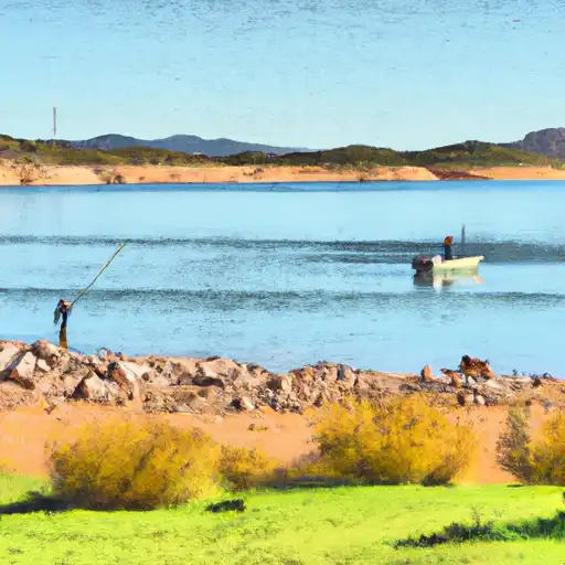
Bartlett Reservoir
What's biting at Bartlett Reservoir
Species commonly reported here -- tap any card for techniques, target seasons, and other waters where it's been caught.
Plan your trip down to the hour
Same weather feed Snoflo's iOS app uses -- updated continuously from NOAA / yr.no.
Next 5 days, hour by hour
Temperature line with weather symbols on top, snow + rain accumulation as columns, humidity as a dotted line.
5-day forecast table
Every 3 hours, broken out across temperature, snow, rain, humidity, and wind. Each cell is colour-coded relative to the column min/max so trends jump out at a glance.
| Time | Condition | Temp (°F) | Snow (in) | Rain (in) | Humidity (%) | Wind (mps) | Wind dir |
|---|---|---|---|---|---|---|---|
| Loading detailed forecast… | |||||||
15-day temperature & precipitation
Daily temperatures, snow, and rain projected over the next two weeks. Hover any point for the full breakdown.
Nearby streamflow
USGS streamgauges within reach of Bartlett Reservoir -- updated continuously from the National Water Information System.
| Streamgauge | Discharge | View |
|---|---|---|
| Verde River Blw Bartlett Dam | 174 cfs | → |
| Sycamore Creek Near Fort Mcdowell | · | → |
| Verde River Near Scottsdale | 101 cfs | → |
| Salt River Blw Stewart Mountain Dam | 481 cfs | → |
| Verde R Blw Tangle Creek | 52 cfs | → |
| Cave Creek Blw Cottonwood Cr Near Cave Creek | · | → |
Plan a longer trip
The closest campgrounds, parks, boat launches, and reservoirs so a fishing run can grow into a weekend.
Campgrounds
Parks
- Wilderness Mazatzal
- George Doc Cavalliere Park
- Pinnacle Peak Park
- Mcdowell Mountain Park
- Florence Ely Nelson Desert Park
- Dc Ranch Park
Reservoirs
- Bartlett
- Red Mountain Freeway Levee
- Horseshoe
- Hesperus Wash (No. 36)
- Aspen (No. 6)
- Stoneridge (No. 19)
Boat launches
- Boat Launch Road [Fsr 185] Maricopa County
- Bartlett Reservoir
- North Bartlett Dam Road Maricopa County
- Box Bar Shoreline Area And River Access Point
- Horseshoe Reservoir
- East Saguaro Del Norte Road 469, Maricopa County
Points of interest
- Balanced Rock
- Sears-Kay Ruin
- Marcus Landslide Loop Trailhead
- Marcus Landslide Loop
- River Of Time Museum
- Carefree Galleria
Paddle runs
- Lower Verde
- Boundary Of The Primary Jurisdiction Below Stewart Mountain Dam To Salt River Indian Reservation Boundary
- Lower Salt
- Salt River Indian Reservation Boundary To Immediately Above Granite Reef Dam Impoundment
- Southern Border Of Mazatzal Wilderness To Sheep Creek Bridge
- Red Creek To Southern Border Of Mazatzal Wilderness
Angling safety & ethics
- Know the regulations
- Check local fishing rules, seasons, size limits, and license requirements to ensure legal and sustainable angling.
- Handle fish responsibly
- Use wet hands, minimize air exposure, and release fish gently to improve survival rates when practicing catch-and-release.
- Choose the right gear
- Match your rod, line, and tackle to the species and conditions to increase success and reduce unnecessary harm to fish.
- Respect the waterway
- Avoid disturbing habitat, prevent bank erosion, and keep a safe distance from spawning areas to protect ecosystems.
- Keep it clean
- Pack out all line, hooks, bait containers, and trash. Discarded gear can injure wildlife and degrade waterways.
Set push alerts in the Snoflo app
Save Bartlett Reservoir as a favorite, set a custom threshold (water temperature, streamflow, snowpack), and the iOS app will push the moment conditions cross.
About Bartlett Reservoir
What fish species are found at Bartlett Reservoir?
Snoflo tracks the species commonly reported at Bartlett Reservoir -- see the Fish Species panel above for the live list with images and links to per-species pages.
How fresh is the weather data on this page?
The hourly forecast updates throughout the day from the NOAA / yr.no public feeds. Streamflow data comes live from USGS streamgauges, also refreshed continuously.
Can I get alerts when conditions change?
Yes -- alerts are managed through the Snoflo iOS app. Favorite this area, set a threshold (water temperature, streamflow, snowpack), and you'll get a push the moment it crosses.
Do I need a fishing license?
Yes. Check your state agency's regulations for license requirements, seasons, size limits, and any waterbody-specific rules before fishing Bartlett Reservoir.
How do I get to Bartlett Reservoir?
Tap Open in map in the hero above to center the Snoflo interactive map on this area, or grab the coordinates from the location facts panel.
Other angling spots near here
Snoflo-tracked fishing areas within driving distance of Bartlett Reservoir.