Yellowstone River river run
Community Reviews
Been here? Share the conditions.
Reviews, ratings & photos are added in the free Snoflo iOS app — rate a spot, tag the conditions, and your visit is verified by location. Add or manage your reviews from the app.
Yellowstone River
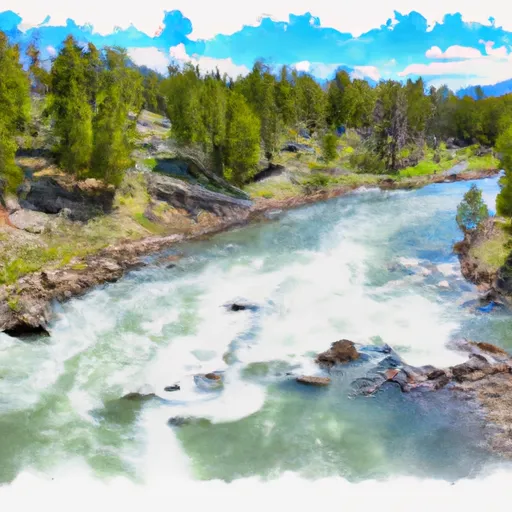
The Whitewater River Run on the Yellowstone River in Montana is a popular destination for kayakers and rafters looking for an exciting adventure. The ideal streamflow range for this river is between 10,000 and 20,000 cubic feet per second (cfs), which provides a good balance of rapids and navigability. The class rating for this section of the river is between III and IV, meaning that it is a moderately difficult run with some significant rapids and obstacles.
The segment mileage for the Whitewater River Run is approximately 18 miles, starting at Gardiner and ending at Yankee Jim Canyon. Along the way, kayakers and rafters will encounter a number of challenging rapids and obstacles, including the famous "Kitchen Sink" rapid. Other notable rapids include "Deadman's Drop," "Big Rock," and "Screaming Left Turn."
In terms of regulations, the Whitewater River Run is subject to the standard boating regulations of Montana, including the requirement for personal flotation devices, proper equipment, and adherence to safety guidelines. Additionally, there are restrictions on commercial outfitting, with only a limited number of permits available each year.
Overall, the Whitewater River Run on the Yellowstone River is a thrilling and challenging adventure for experienced kayakers and rafters looking for an adrenaline-fueled ride. With its ideal streamflow range, class rating, and specific rapids and obstacles, this run is sure to provide a memorable experience for anyone looking to test their skills on the river.
Plan your run down to the hour
Same weather feed Snoflo's iOS app uses -- updated continuously from NOAA / yr.no. Watch the precipitation column on the meteogram; rain ahead of a run typically lifts flows 12-48 hours later depending on the basin.
Next 5 days, hour by hour
Temperature line with weather symbols on top, snow + rain accumulation as columns, humidity as a dotted line.
5-day forecast table
Every 3 hours, broken out across temperature, snow, rain, humidity, and wind. Each cell is colour-coded relative to the column min/max.
| Time | Condition | Temp (°F) | Snow (in) | Rain (in) | Humidity (%) | Wind (mps) | Wind dir |
|---|---|---|---|---|---|---|---|
| Loading detailed forecast… | |||||||
15-day temperature & precipitation
Daily temperatures, snow, and rain projected over the next two weeks -- the upstream story that drives next week's flows.
Regional streamflow levels
USGS streamgauges around Yellowstone River -- useful for spotting upstream pulses and gauging which tributary is contributing what.
| Streamgauge | Discharge | View |
|---|---|---|
| Pryor Creek Nr Huntley Mt | 21 cfs | → |
| Yellowstone River At Billings Mt | 8,180 cfs | → |
| Bighorn River Ab Tullock Cr Nr Bighorn Mt | 1,530 cfs | → |
| Little Bighorn River Near Hardin Mt | 68 cfs | → |
| Musselshell River At Musselshell Mt | 131 cfs | → |
| Musselshell River Near Roundup Mt | 178 cfs | → |
Plan a longer trip
The closest boat launches, other paddle runs, and campgrounds so a day on the water can grow into a full weekend.
Fishing spots
Whitewater safety
- Check the flow before you run
- Use the linked-gauge card and Regional Flow panel above. Class ratings change with flow -- a Class III at low water can become Class IV+ at high water.
- Know your skill ceiling
- Pick runs comfortably below your ceiling. Cold-water and big-water runs raise the consequences of any mistake.
- Wear the right gear
- Helmet, PFD, drysuit / wetsuit when water is below 60°F. Throw bag, knife, and whistle on your person, not in the boat.
- Scout, set safety, and run with a team
- Scout new rapids on foot, set safety with throw bags above the consequence pool, and run with at least one other competent paddler.
- Respect the river
- Strainers, undercuts, low-head dams, and wood can kill at any class rating. When in doubt, portage.
Set push alerts in the Snoflo app
Save Yellowstone River as a favorite, set a discharge threshold (e.g. "alert me when flow hits 600 cfs"), and the iOS app pushes the moment the linked gauge crosses.
About Yellowstone River
What's the optimal flow for Yellowstone River?
The optimal flow depends on the section and the craft. Check the Run Details panel for the linked gauge and current status.
How fresh is the cfs reading on this page?
The linked USGS streamgauge reports continuously (every 15 minutes); Snoflo refreshes throughout the day. Hover the streamflow sparkline to read individual datapoints.
What's the whitewater class?
See the Run Details panel for the class rating Snoflo tracks for this run. Class ratings change with flow -- a Class III at low water can become Class IV in high water.
Where do I put in / take out?
Tap Directions in the hero above to open driving directions to the put-in. For shuttle planning, check the Nearby Boat Launches panel and the river run operator's site.
Can I get alerts when flows hit the optimal range?
Yes -- alerts are managed in the Snoflo iOS app. Favorite this run, set a discharge threshold, and you'll get a push the moment the gauge crosses.
Other runs near here
Snoflo-tracked paddle runs within driving distance of Yellowstone River.