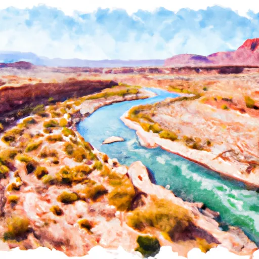
The Border Of Np Land And Navajo & Hopi Tribal Lands. To Confluence With The Colorado River River Run
Community Reviews
Been here? Share the conditions.
Reviews, ratings & photos are added in the free Snoflo iOS app — rate a spot, tag the conditions, and your visit is verified by location. Add or manage your reviews from the app.
The Border Of Np Land And Navajo & Hopi Tribal Lands. To Confluence With The Colorado River
Some of the specific river rapids and obstacles that paddlers will encounter during the Whitewater River Run include the Eye of the Needle, the Devil's Corkscrew, the Canyon Doors, and the Black Rock. Paddlers need to be aware of the specific regulations governing the area, including obtaining the necessary permits from the Navajo Nation Parks & Recreation Department, respecting the cultural and religious beliefs of the tribe, and preserving the environment by packing out all trash.
In summary, the Whitewater River Run is an exciting and challenging white water rafting destination suitable for intermediate to advanced paddlers. Paddlers need to follow specific regulations and obtain the necessary permits to respect the cultural and environmental significance of the Tribal Lands and National Park area.
Plan your run down to the hour
Same weather feed Snoflo's iOS app uses -- updated continuously from NOAA / yr.no. Watch the precipitation column on the meteogram; rain ahead of a run typically lifts flows 12-48 hours later depending on the basin.
Next 5 days, hour by hour
Temperature line with weather symbols on top, snow + rain accumulation as columns, humidity as a dotted line.
5-day forecast table
Every 3 hours, broken out across temperature, snow, rain, humidity, and wind. Each cell is colour-coded relative to the column min/max.
| Time | Condition | Temp (°F) | Snow (in) | Rain (in) | Humidity (%) | Wind (mps) | Wind dir |
|---|---|---|---|---|---|---|---|
| Loading detailed forecast… | |||||||
15-day temperature & precipitation
Daily temperatures, snow, and rain projected over the next two weeks -- the upstream story that drives next week's flows.
Regional streamflow levels
USGS streamgauges around The Border Of Np Land And Navajo & Hopi Tribal Lands. To Confluence With The Colorado River -- useful for spotting upstream pulses and gauging which tributary is contributing what.
| Streamgauge | Discharge | View |
|---|---|---|
| Little Colorado River Abv Mouth Nr Desert View | 683 cfs | → |
| Colorado River Near Grand Canyon | 8,440 cfs | → |
| Little Colorado River Near Cameron | 171 cfs | → |
| Moenkopi Wash At Moenkopi | · | → |
| Colorado River At Lees Ferry | 8,990 cfs | → |
| Paria River At Lees Ferry | 3 cfs | → |
Plan a longer trip
The closest boat launches, other paddle runs, and campgrounds so a day on the water can grow into a full weekend.
Other river runs
- Eastern Edge Of Kwagunt Valley (Past The Butte Fault) To Confluence With The Colorado River
- First Major North Arm Of Lava Creek At The Base Of Chiavria Point To Confluence With The Colorado River
- Confluence With Nankoweap Creek To Red Canyon And The Beginning Of Upper Granite Gorge
- Begins Just Over 1 Mile Beyond Where The Nankoweap Trails Leaves The Creek And Heads Off To The North. To Confluence With The Colorado River
- Cheyava Falls To Confluence With The Colorado River
Campgrounds
Whitewater safety
- Check the flow before you run
- Use the linked-gauge card and Regional Flow panel above. Class ratings change with flow -- a Class III at low water can become Class IV+ at high water.
- Know your skill ceiling
- Pick runs comfortably below your ceiling. Cold-water and big-water runs raise the consequences of any mistake.
- Wear the right gear
- Helmet, PFD, drysuit / wetsuit when water is below 60°F. Throw bag, knife, and whistle on your person, not in the boat.
- Scout, set safety, and run with a team
- Scout new rapids on foot, set safety with throw bags above the consequence pool, and run with at least one other competent paddler.
- Respect the river
- Strainers, undercuts, low-head dams, and wood can kill at any class rating. When in doubt, portage.
Set push alerts in the Snoflo app
Save The Border Of Np Land And Navajo & Hopi Tribal Lands. To Confluence With The Colorado River as a favorite, set a discharge threshold (e.g. "alert me when flow hits 600 cfs"), and the iOS app pushes the moment the linked gauge crosses.
About The Border Of Np Land And Navajo & Hopi Tribal Lands. To Confluence With The Colorado River
What's the optimal flow for The Border Of Np Land And Navajo & Hopi Tribal Lands. To Confluence With The Colorado River?
The optimal flow depends on the section and the craft. Check the Run Details panel for the linked gauge and current status.
How fresh is the cfs reading on this page?
The linked USGS streamgauge reports continuously (every 15 minutes); Snoflo refreshes throughout the day. Hover the streamflow sparkline to read individual datapoints.
What's the whitewater class?
See the Run Details panel for the class rating Snoflo tracks for this run. Class ratings change with flow -- a Class III at low water can become Class IV in high water.
Where do I put in / take out?
Tap Directions in the hero above to open driving directions to the put-in. For shuttle planning, check the Nearby Boat Launches panel and the river run operator's site.
Can I get alerts when flows hit the optimal range?
Yes -- alerts are managed in the Snoflo iOS app. Favorite this run, set a discharge threshold, and you'll get a push the moment the gauge crosses.
Other runs near here
Snoflo-tracked paddle runs within driving distance of The Border Of Np Land And Navajo & Hopi Tribal Lands. To Confluence With The Colorado River.