Summary
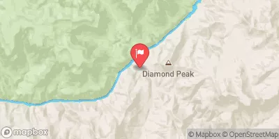
The ideal streamflow range for this river is between 9,000 and 25,000 cubic feet per second (cfs), which occurs during the spring and early summer months. The segment mileage of this run is approximately 280 miles, starting at the southern boundary of Grand Canyon National Park and ending at the confluence with the Colorado River.
The Class rating for this river ranges from Class III to Class V, depending on the specific rapids and obstacles encountered. Some of the most notable rapids on this run include Hance Rapid, Horn Creek Rapid, and Lava Falls.
While this river run is a thrilling adventure, it is important to note that there are specific regulations in place to ensure that it is done safely and responsibly. The National Park Service requires all participants to obtain a permit before embarking on the river run, and all boats must be equipped with proper safety gear, including life jackets and first aid kits.
Overall, the Whitewater River Run is an exciting and challenging adventure for experienced whitewater enthusiasts, but it is important to exercise caution and adhere to all regulations to ensure a safe and enjoyable experience.
°F
°F
mph
Wind
%
Humidity
15-Day Weather Outlook
River Run Details
| Last Updated | 2026-02-07 |
| River Levels | 70 cfs (7.14 ft) |
| Percent of Normal | 96% |
| Status | |
| Class Level | iii-v |
| Elevation | ft |
| Run Length | 3.0 Mi |
| Streamflow Discharge | cfs |
| Gauge Height | ft |
| Reporting Streamgage | USGS 09404115 |
5-Day Hourly Forecast Detail
Nearby Streamflow Levels
River Runs
-
 Southern Boundary Of Grand Canyon National Park To Confluence With The Colorado River
-
 Begins 2 Miles Upstream From Confluence With The Colorado River To Confluence With The Colorado River
-
 Begins 1.5 Miles Upstream From Confluence With The Colorado River To Confluence With The Colorado River
-
 Confluence With Kanab Creek To Spencer Canyon
-
 Begins 0.5 Miles Upstream From The Confluence With The Colorado River
C To Confluence With The Colorado River


