Confluence With Cocomunga Creek To Confluence With Gun Creek River Run
Community Reviews
Been here? Share the conditions.
Reviews, ratings & photos are added in the free Snoflo iOS app — rate a spot, tag the conditions, and your visit is verified by location. Add or manage your reviews from the app.
Confluence With Cocomunga Creek To Confluence With Gun Creek
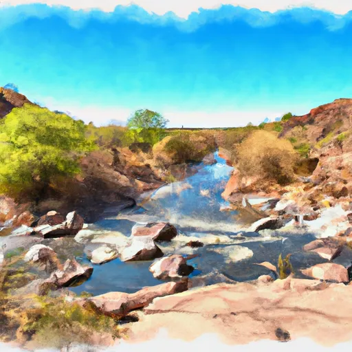
The Cradle section is a steep, narrow drop with large rocks and boulders that require precise navigation. The Chute section is a long series of rapids that require advanced paddling skills to navigate. Other notable rapids include the "S-Turns," "Kitchen Sink," and "Jug Handle."
There are specific regulations that must be followed when kayaking or rafting on the Whitewater River. All participants must wear a life jacket and helmets, and it is recommended to have a guide or experienced kayaker with you. Additionally, the use of alcohol and drugs is strictly prohibited, and littering or damaging the natural environment can result in fines and legal action.
Overall, the Whitewater River run from Confluence with Cocomunga Creek to Confluence with Gun Creek is a challenging and rewarding experience for experienced kayakers and rafters. It is important to follow all regulations and safety guidelines to ensure a safe and enjoyable trip.
Plan your run down to the hour
Same weather feed Snoflo's iOS app uses -- updated continuously from NOAA / yr.no. Watch the precipitation column on the meteogram; rain ahead of a run typically lifts flows 12-48 hours later depending on the basin.
Next 5 days, hour by hour
Temperature line with weather symbols on top, snow + rain accumulation as columns, humidity as a dotted line.
5-day forecast table
Every 3 hours, broken out across temperature, snow, rain, humidity, and wind. Each cell is colour-coded relative to the column min/max.
| Time | Condition | Temp (°F) | Snow (in) | Rain (in) | Humidity (%) | Wind (mps) | Wind dir |
|---|---|---|---|---|---|---|---|
| Loading detailed forecast… | |||||||
15-day temperature & precipitation
Daily temperatures, snow, and rain projected over the next two weeks -- the upstream story that drives next week's flows.
Regional streamflow levels
USGS streamgauges around Confluence With Cocomunga Creek To Confluence With Gun Creek -- useful for spotting upstream pulses and gauging which tributary is contributing what.
| Streamgauge | Discharge | View |
|---|---|---|
| Tonto Creek Abv Gun Creek | · | → |
| East Verde R Div From East Clear Cr Nr Pine | 1 cfs | → |
| Wet Bottom Creek Near Childs | · | → |
| East Verde River Near Childs | · | → |
| Verde R Blw Tangle Creek | 54 cfs | → |
| South Fork Parker Creek Near Roosevelt | 0 cfs | → |
Plan a longer trip
The closest boat launches, other paddle runs, and campgrounds so a day on the water can grow into a full weekend.
Other river runs
- Hell's Gate Canyon
- Hellsgate Wilderness Boundary To Confluence With Tonto Creek
- Forest Road 486 To Hellsgate Wilderness Boundary
- Approximately 9 Miles Below The Headwaters At The West Boundary Of East Verde Park Estates To West Boundary Of L.F. Ranch
- West Boundary Of L.F. Ranch To Verde Wild And Scenic River
Campgrounds
- Payson Campground & Rv Resort
- Houston Mesa Campground
- Houston Mesa Campground And Equestrian Sites
- Houston Mesa
- Flowing Springs
- Flowing Springs Dispersed
Whitewater safety
- Check the flow before you run
- Use the linked-gauge card and Regional Flow panel above. Class ratings change with flow -- a Class III at low water can become Class IV+ at high water.
- Know your skill ceiling
- Pick runs comfortably below your ceiling. Cold-water and big-water runs raise the consequences of any mistake.
- Wear the right gear
- Helmet, PFD, drysuit / wetsuit when water is below 60°F. Throw bag, knife, and whistle on your person, not in the boat.
- Scout, set safety, and run with a team
- Scout new rapids on foot, set safety with throw bags above the consequence pool, and run with at least one other competent paddler.
- Respect the river
- Strainers, undercuts, low-head dams, and wood can kill at any class rating. When in doubt, portage.
Set push alerts in the Snoflo app
Save Confluence With Cocomunga Creek To Confluence With Gun Creek as a favorite, set a discharge threshold (e.g. "alert me when flow hits 600 cfs"), and the iOS app pushes the moment the linked gauge crosses.
About Confluence With Cocomunga Creek To Confluence With Gun Creek
What's the optimal flow for Confluence With Cocomunga Creek To Confluence With Gun Creek?
The optimal flow depends on the section and the craft. Check the Run Details panel for the linked gauge and current status.
How fresh is the cfs reading on this page?
The linked USGS streamgauge reports continuously (every 15 minutes); Snoflo refreshes throughout the day. Hover the streamflow sparkline to read individual datapoints.
What's the whitewater class?
See the Run Details panel for the class rating Snoflo tracks for this run. Class ratings change with flow -- a Class III at low water can become Class IV in high water.
Where do I put in / take out?
Tap Directions in the hero above to open driving directions to the put-in. For shuttle planning, check the Nearby Boat Launches panel and the river run operator's site.
Can I get alerts when flows hit the optimal range?
Yes -- alerts are managed in the Snoflo iOS app. Favorite this run, set a discharge threshold, and you'll get a push the moment the gauge crosses.
Other runs near here
Snoflo-tracked paddle runs within driving distance of Confluence With Cocomunga Creek To Confluence With Gun Creek.