Northern Boundary Of Hellsgate Wilderness To Southern Boundary Of Hellsgate Wilderness river run
Community Reviews
Been here? Share the conditions.
Reviews, ratings & photos are added in the free Snoflo iOS app — rate a spot, tag the conditions, and your visit is verified by location. Add or manage your reviews from the app.
Northern Boundary Of Hellsgate Wilderness To Southern Boundary Of Hellsgate Wilderness
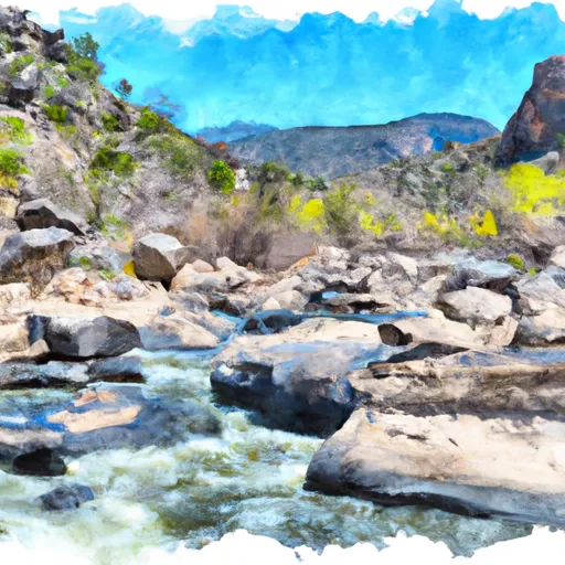
The Whitewater River Run in Arizona is a popular destination for whitewater enthusiasts, with a variety of rapids and obstacles to navigate. The ideal streamflow range for this run is typically between 500 and 3000 cubic feet per second (cfs), which provides enough water to make the rapids challenging but not dangerous. The run is rated as Class III to IV, with some sections reaching Class V.
The run begins at the Northern Boundary of Hellsgate Wilderness and ends at the Southern Boundary of Hellsgate Wilderness, covering a distance of approximately 11 miles. Along the way, paddlers will encounter a variety of rapids and obstacles, including the infamous Hell's Hole, which is rated as a Class V rapid. Other notable rapids include Quartzite Falls, Triple Drop, and Cow Flat Rapid.
In addition to the natural challenges of the river, there are also specific regulations that paddlers must follow. For example, all boaters are required to carry a throwable rescue device, a personal flotation device, and a whistle. There are also restrictions on camping and fires in certain areas, as well as restrictions on the use of motorized boats.
Overall, the Whitewater River Run is a challenging and rewarding experience for experienced whitewater paddlers. It is important to check current streamflow levels and weather conditions before embarking on this adventure, and to follow all applicable regulations to ensure a safe and enjoyable trip.
Plan your run down to the hour
Same weather feed Snoflo's iOS app uses -- updated continuously from NOAA / yr.no. Watch the precipitation column on the meteogram; rain ahead of a run typically lifts flows 12-48 hours later depending on the basin.
Next 5 days, hour by hour
Temperature line with weather symbols on top, snow + rain accumulation as columns, humidity as a dotted line.
5-day forecast table
Every 3 hours, broken out across temperature, snow, rain, humidity, and wind. Each cell is colour-coded relative to the column min/max.
| Time | Condition | Temp (°F) | Snow (in) | Rain (in) | Humidity (%) | Wind (mps) | Wind dir |
|---|---|---|---|---|---|---|---|
| Loading detailed forecast… | |||||||
15-day temperature & precipitation
Daily temperatures, snow, and rain projected over the next two weeks -- the upstream story that drives next week's flows.
Regional streamflow levels
USGS streamgauges around Northern Boundary Of Hellsgate Wilderness To Southern Boundary Of Hellsgate Wilderness -- useful for spotting upstream pulses and gauging which tributary is contributing what.
| Streamgauge | Discharge | View |
|---|---|---|
| East Verde R Div From East Clear Cr Nr Pine | 1 cfs | → |
| Tonto Creek Abv Gun Creek | · | → |
| Chevelon Fork Below Wildcat Canyon | · | → |
| East Verde River Near Childs | · | → |
| Cherry Creek Near Globe | 2 cfs | → |
| South Fork Parker Creek Near Roosevelt | · | → |
Plan a longer trip
The closest boat launches, other paddle runs, and campgrounds so a day on the water can grow into a full weekend.
Boat launches
Other river runs
- Christopher Creek
- One Mile Below Woods Canyon Lake Dam (Woods Canyon) To Confluence With Chevelon Canyon
- Hellsgate Wilderness Boundary To Confluence With Tonto Creek
Campgrounds
- Christopher Creek Campground And Group Site
- Ponderosa
- Christopher Creek
- Ponderosa Campground And Group Sites
- Tonto Creek
- Lower Tonto Creek Campground
Whitewater safety
- Check the flow before you run
- Use the linked-gauge card and Regional Flow panel above. Class ratings change with flow -- a Class III at low water can become Class IV+ at high water.
- Know your skill ceiling
- Pick runs comfortably below your ceiling. Cold-water and big-water runs raise the consequences of any mistake.
- Wear the right gear
- Helmet, PFD, drysuit / wetsuit when water is below 60°F. Throw bag, knife, and whistle on your person, not in the boat.
- Scout, set safety, and run with a team
- Scout new rapids on foot, set safety with throw bags above the consequence pool, and run with at least one other competent paddler.
- Respect the river
- Strainers, undercuts, low-head dams, and wood can kill at any class rating. When in doubt, portage.
Set push alerts in the Snoflo app
Save Northern Boundary Of Hellsgate Wilderness To Southern Boundary Of Hellsgate Wilderness as a favorite, set a discharge threshold (e.g. "alert me when flow hits 600 cfs"), and the iOS app pushes the moment the linked gauge crosses.
About Northern Boundary Of Hellsgate Wilderness To Southern Boundary Of Hellsgate Wilderness
What's the optimal flow for Northern Boundary Of Hellsgate Wilderness To Southern Boundary Of Hellsgate Wilderness?
The optimal flow depends on the section and the craft. Check the Run Details panel for the linked gauge and current status.
How fresh is the cfs reading on this page?
The linked USGS streamgauge reports continuously (every 15 minutes); Snoflo refreshes throughout the day. Hover the streamflow sparkline to read individual datapoints.
What's the whitewater class?
See the Run Details panel for the class rating Snoflo tracks for this run. Class ratings change with flow -- a Class III at low water can become Class IV in high water.
Where do I put in / take out?
Tap Directions in the hero above to open driving directions to the put-in. For shuttle planning, check the Nearby Boat Launches panel and the river run operator's site.
Can I get alerts when flows hit the optimal range?
Yes -- alerts are managed in the Snoflo iOS app. Favorite this run, set a discharge threshold, and you'll get a push the moment the gauge crosses.
Other runs near here
Snoflo-tracked paddle runs within driving distance of Northern Boundary Of Hellsgate Wilderness To Southern Boundary Of Hellsgate Wilderness.