South Fork From Antelope Campground To One-Quarter Mile Above North Fork Antelope Creek River Run
Community Reviews
Been here? Share the conditions.
Reviews, ratings & photos are added in the free Snoflo iOS app — rate a spot, tag the conditions, and your visit is verified by location. Add or manage your reviews from the app.
South Fork From Antelope Campground To One-Quarter Mile Above North Fork Antelope Creek
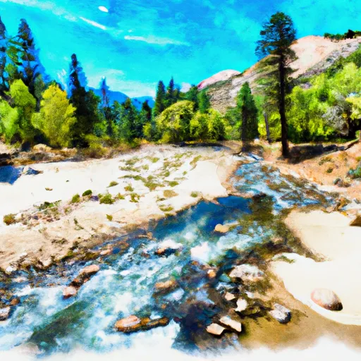
The Whitewater River Run South Fork from Antelope Campground to one-quarter mile above North Fork Antelope Creek in California is a popular destination for rafting and kayaking enthusiasts. The ideal streamflow range for this section of the river is between 500 and 1,200 cubic feet per second (cfs). The class rating for this section of the river is Class III-IV, which means it has moderately difficult rapids that require a high skill level.
The segment mileage for this section of the river is around 21 miles, and it is known for its beautiful scenery and challenging rapids. Some of the specific river rapids/obstacles that rafters and kayakers will encounter on this section include Slab Creek, Texas Chainsaw Massacre, and Golden Gate.
In terms of regulations, the California Department of Parks and Recreation manages the area and has specific rules that must be followed. For example, all boats must have a U.S. Coast Guard approved life jacket for each person on board, and no glass containers are allowed on the river. Additionally, all boaters must have a permit to use the river, and fires are only allowed in designated areas.
Plan your run down to the hour
Same weather feed Snoflo's iOS app uses -- updated continuously from NOAA / yr.no. Watch the precipitation column on the meteogram; rain ahead of a run typically lifts flows 12-48 hours later depending on the basin.
Next 5 days, hour by hour
Temperature line with weather symbols on top, snow + rain accumulation as columns, humidity as a dotted line.
5-day forecast table
Every 3 hours, broken out across temperature, snow, rain, humidity, and wind. Each cell is colour-coded relative to the column min/max.
| Time | Condition | Temp (°F) | Snow (in) | Rain (in) | Humidity (%) | Wind (mps) | Wind dir |
|---|---|---|---|---|---|---|---|
| Loading detailed forecast… | |||||||
15-day temperature & precipitation
Daily temperatures, snow, and rain projected over the next two weeks -- the upstream story that drives next week's flows.
Regional streamflow levels
USGS streamgauges around South Fork From Antelope Campground To One-Quarter Mile Above North Fork Antelope Creek -- useful for spotting upstream pulses and gauging which tributary is contributing what.
| Streamgauge | Discharge | View |
|---|---|---|
| Mill C Nr Los Molinos Ca | 136 cfs | → |
| Deer C Nr Vina Ca | 99 cfs | → |
| Sacramento R Ab Bend Bridge Nr Red Bluff Ca | 13,300 cfs | → |
| Battle C Bl Coleman Fish Hatchery Nr Cottonwood Ca | 245 cfs | → |
| Cottonwood C Nr Cottonwood Ca | 64 cfs | → |
| Cow C Nr Millville Ca | 34 cfs | → |
Plan a longer trip
The closest boat launches, other paddle runs, and campgrounds so a day on the water can grow into a full weekend.
Other river runs
- Mcclure Place (North Fork) To Nf Boundary At Payne Place (Dept. Of Fish And Game Land)
- North Fork From Nf Boundary At Section Line Between 17/18, T28n, R1e. To Mcclure Place
- Mill Creek
- One Mile Downstream From Black Rock To Western Nf Boundary
- Sec Line Between 14/23, T27n, R2e To One Mile Downstream From Black Rock
Campgrounds
- Facht Place Campground
- Battle Creek Campground
- Battle Creek
- Hole In The Ground
- Hole-In-The-Ground Campground
- Massacre Flat
Fishing spots
Points of interest
Whitewater safety
- Check the flow before you run
- Use the linked-gauge card and Regional Flow panel above. Class ratings change with flow -- a Class III at low water can become Class IV+ at high water.
- Know your skill ceiling
- Pick runs comfortably below your ceiling. Cold-water and big-water runs raise the consequences of any mistake.
- Wear the right gear
- Helmet, PFD, drysuit / wetsuit when water is below 60°F. Throw bag, knife, and whistle on your person, not in the boat.
- Scout, set safety, and run with a team
- Scout new rapids on foot, set safety with throw bags above the consequence pool, and run with at least one other competent paddler.
- Respect the river
- Strainers, undercuts, low-head dams, and wood can kill at any class rating. When in doubt, portage.
Set push alerts in the Snoflo app
Save South Fork From Antelope Campground To One-Quarter Mile Above North Fork Antelope Creek as a favorite, set a discharge threshold (e.g. "alert me when flow hits 600 cfs"), and the iOS app pushes the moment the linked gauge crosses.
About South Fork From Antelope Campground To One-Quarter Mile Above North Fork Antelope Creek
What's the optimal flow for South Fork From Antelope Campground To One-Quarter Mile Above North Fork Antelope Creek?
The optimal flow depends on the section and the craft. Check the Run Details panel for the linked gauge and current status.
How fresh is the cfs reading on this page?
The linked USGS streamgauge reports continuously (every 15 minutes); Snoflo refreshes throughout the day. Hover the streamflow sparkline to read individual datapoints.
What's the whitewater class?
See the Run Details panel for the class rating Snoflo tracks for this run. Class ratings change with flow -- a Class III at low water can become Class IV in high water.
Where do I put in / take out?
Tap Directions in the hero above to open driving directions to the put-in. For shuttle planning, check the Nearby Boat Launches panel and the river run operator's site.
Can I get alerts when flows hit the optimal range?
Yes -- alerts are managed in the Snoflo iOS app. Favorite this run, set a discharge threshold, and you'll get a push the moment the gauge crosses.
Other runs near here
Snoflo-tracked paddle runs within driving distance of South Fork From Antelope Campground To One-Quarter Mile Above North Fork Antelope Creek.