Englebright Lake Fishing
As of August 2, 2026, the nearest streamgauge to Englebright Lake — Deer C Nr Smartville Ca — reports 11 cfs. Source: USGS gauge data, refreshed throughout the day.
Community Reviews
Been here? Share the conditions.
Reviews, ratings & photos are added in the free Snoflo iOS app — rate a spot, tag the conditions, and your visit is verified by location. Add or manage your reviews from the app.
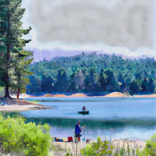
Englebright Lake
What's biting at Englebright Lake
Species commonly reported here -- tap any card for techniques, target seasons, and other waters where it's been caught.
Plan your trip down to the hour
Same weather feed Snoflo's iOS app uses -- updated continuously from NOAA / yr.no.
Next 5 days, hour by hour
Temperature line with weather symbols on top, snow + rain accumulation as columns, humidity as a dotted line.
5-day forecast table
Every 3 hours, broken out across temperature, snow, rain, humidity, and wind. Each cell is colour-coded relative to the column min/max so trends jump out at a glance.
| Time | Condition | Temp (°F) | Snow (in) | Rain (in) | Humidity (%) | Wind (mps) | Wind dir |
|---|---|---|---|---|---|---|---|
| Loading detailed forecast… | |||||||
15-day temperature & precipitation
Daily temperatures, snow, and rain projected over the next two weeks. Hover any point for the full breakdown.
Nearby streamflow
USGS streamgauges within reach of Englebright Lake -- updated continuously from the National Water Information System.
| Streamgauge | Discharge | View |
|---|---|---|
| Deer C Nr Smartville Ca | 11 cfs | → |
| Yuba R Nr Marysville Ca | 533 cfs | → |
| Bear R Nr Wheatland Ca | 26 cfs | → |
| Nf American R A North Fork Dam Ca | 63 cfs | → |
| N Yuba R Bl Goodyears Bar Ca | 139 cfs | → |
| Sacramento R Bl Wilkins Slough Nr Grimes Ca | 7,580 cfs | → |
Plan a longer trip
The closest campgrounds, parks, boat launches, and reservoirs so a fishing run can grow into a weekend.
Campgrounds
- Collins Lake Rv Park & Campground
- Beale Afb Military
- Nevada County Fairgrounds
- Hornswoggle Group Campground
- Garden Point Campground
- Garden Point
Parks
- Western Gateway Regional Park
- South Yuba River State Park
- Plumas National Forest
- Devere Mautino Community Park
- Condon Park
- Spenceville Wildlife Area
Reservoirs
Boat launches
- Englebright Reservoir (Narrows)
- Englebright Reservoir (Joe Miller)
- Yuba County
- Bullards Bar Reservoir (Cottage Creek )
- North Recreation Area
- Bullards Bar Reservoir (Dark Day )
Points of interest
- Bridgeport Covered Bridge
- World's First Long-Distance Telephone Line
- North Star Museum
- Purdon Crossing
- Nevada County Narrow Guage Railroad Museum
- Firehouse Number 1 Museum
Paddle runs
- Confluence With Jefferson Creek To Confluence With Kentucky Creek
- One-Quarter Mile Upstream From Confluence With Slate Creek To Bullards Bar Reservoir Spillway (Elevation 1902 Feet)
- One-Eighth Mile Downstream From Confluence With Cherokee Creek To One-Quarter Mile Upstream From Confluence With Slate Creek
- Chamberlain Falls (Iowa Hill To Yankee Jim)
- Headwaters Of North Yuba River (Sec 10, T20n, R13 E) To One-Eighth Mile Downstream Of Confluence With Cherokee Creek
- Slate Reservoir To North Yuba River
Angling safety & ethics
- Know the regulations
- Check local fishing rules, seasons, size limits, and license requirements to ensure legal and sustainable angling.
- Handle fish responsibly
- Use wet hands, minimize air exposure, and release fish gently to improve survival rates when practicing catch-and-release.
- Choose the right gear
- Match your rod, line, and tackle to the species and conditions to increase success and reduce unnecessary harm to fish.
- Respect the waterway
- Avoid disturbing habitat, prevent bank erosion, and keep a safe distance from spawning areas to protect ecosystems.
- Keep it clean
- Pack out all line, hooks, bait containers, and trash. Discarded gear can injure wildlife and degrade waterways.
Set push alerts in the Snoflo app
Save Englebright Lake as a favorite, set a custom threshold (water temperature, streamflow, snowpack), and the iOS app will push the moment conditions cross.
About Englebright Lake
What fish species are found at Englebright Lake?
Snoflo tracks the species commonly reported at Englebright Lake -- see the Fish Species panel above for the live list with images and links to per-species pages.
How fresh is the weather data on this page?
The hourly forecast updates throughout the day from the NOAA / yr.no public feeds. Streamflow data comes live from USGS streamgauges, also refreshed continuously.
Can I get alerts when conditions change?
Yes -- alerts are managed through the Snoflo iOS app. Favorite this area, set a threshold (water temperature, streamflow, snowpack), and you'll get a push the moment it crosses.
Do I need a fishing license?
Yes. Check your state agency's regulations for license requirements, seasons, size limits, and any waterbody-specific rules before fishing Englebright Lake.
How do I get to Englebright Lake?
Tap Open in map in the hero above to center the Snoflo interactive map on this area, or grab the coordinates from the location facts panel.
Other angling spots near here
Snoflo-tracked fishing areas within driving distance of Englebright Lake.