Ten Mile Creek Headwaters To Confluence With Clear Creek River Run
Community Reviews
Been here? Share the conditions.
Reviews, ratings & photos are added in the free Snoflo iOS app — rate a spot, tag the conditions, and your visit is verified by location. Add or manage your reviews from the app.
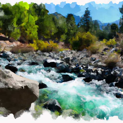
Ten Mile Creek Headwaters To Confluence With Clear Creek
The Ten Mile Creek Headwaters to Confluence with Clear Creek section is located in a remote area of Shasta County and runs through private property. Access to the river is limited and only allowed through the Shasta-Trinity National Forest. It is important to check with the local authorities for any specific regulations before planning a trip to this section.
Overall, this section of Ten Mile Creek offers an adventurous, technical whitewater experience for experienced paddlers. It is important to note that the rapids in this section can be dangerous and should only be attempted by those with advanced skills and proper equipment.
Plan your run down to the hour
Same weather feed Snoflo's iOS app uses -- updated continuously from NOAA / yr.no. Watch the precipitation column on the meteogram; rain ahead of a run typically lifts flows 12-48 hours later depending on the basin.
Next 5 days, hour by hour
Temperature line with weather symbols on top, snow + rain accumulation as columns, humidity as a dotted line.
5-day forecast table
Every 3 hours, broken out across temperature, snow, rain, humidity, and wind. Each cell is colour-coded relative to the column min/max.
| Time | Condition | Temp (°F) | Snow (in) | Rain (in) | Humidity (%) | Wind (mps) | Wind dir |
|---|---|---|---|---|---|---|---|
| Loading detailed forecast… | |||||||
15-day temperature & precipitation
Daily temperatures, snow, and rain projected over the next two weeks -- the upstream story that drives next week's flows.
Regional streamflow levels
USGS streamgauges around Ten Mile Creek Headwaters To Confluence With Clear Creek -- useful for spotting upstream pulses and gauging which tributary is contributing what.
| Streamgauge | Discharge | View |
|---|---|---|
| Indian C Nr Happy Camp Ca | 43 cfs | → |
| Klamath R Nr Seiad Valley Ca | 1,090 cfs | → |
| Salmon R A Somes Bar Ca | 269 cfs | → |
| Smith R Nr Crescent City Ca | 310 cfs | → |
| Klamath R Nr Klamath Ca | 2,700 cfs | → |
| Scott R Nr Fort Jones Ca | 28 cfs | → |
Plan a longer trip
The closest boat launches, other paddle runs, and campgrounds so a day on the water can grow into a full weekend.
Boat launches
- P. Wingate Bar River Access
- Wingate Bar
- R. Independence Rest Area /River Access
- Q. Ferry Point River Access
- O. Chambers Flat River Access
- S. Coon Creek River Access
Other river runs
- Headwaters In Siskiyou Wilderness To Confluence With Ten Mile Creek
- Confluence With Ten Mile Creek To Confluence With Daggett Creek
- West Fork Clear Creek Headwaters To Confluence With Clear Creek
- Confluence With Daggett Creek To Confluence With Klamath River
- Bridge In Sec 25 To Confluence With Klamath River
Campgrounds
- Curly Jack Campground
- Curly Jack
- Dillon
- Dillon Creek Campground
- Bear Basin Butte Lookout / Pierson Cabin
- Elk Hole Camp
Fishing spots
Whitewater safety
- Check the flow before you run
- Use the linked-gauge card and Regional Flow panel above. Class ratings change with flow -- a Class III at low water can become Class IV+ at high water.
- Know your skill ceiling
- Pick runs comfortably below your ceiling. Cold-water and big-water runs raise the consequences of any mistake.
- Wear the right gear
- Helmet, PFD, drysuit / wetsuit when water is below 60°F. Throw bag, knife, and whistle on your person, not in the boat.
- Scout, set safety, and run with a team
- Scout new rapids on foot, set safety with throw bags above the consequence pool, and run with at least one other competent paddler.
- Respect the river
- Strainers, undercuts, low-head dams, and wood can kill at any class rating. When in doubt, portage.
Set push alerts in the Snoflo app
Save Ten Mile Creek Headwaters To Confluence With Clear Creek as a favorite, set a discharge threshold (e.g. "alert me when flow hits 600 cfs"), and the iOS app pushes the moment the linked gauge crosses.
About Ten Mile Creek Headwaters To Confluence With Clear Creek
What's the optimal flow for Ten Mile Creek Headwaters To Confluence With Clear Creek?
The optimal flow depends on the section and the craft. Check the Run Details panel for the linked gauge and current status.
How fresh is the cfs reading on this page?
The linked USGS streamgauge reports continuously (every 15 minutes); Snoflo refreshes throughout the day. Hover the streamflow sparkline to read individual datapoints.
What's the whitewater class?
See the Run Details panel for the class rating Snoflo tracks for this run. Class ratings change with flow -- a Class III at low water can become Class IV in high water.
Where do I put in / take out?
Tap Directions in the hero above to open driving directions to the put-in. For shuttle planning, check the Nearby Boat Launches panel and the river run operator's site.
Can I get alerts when flows hit the optimal range?
Yes -- alerts are managed in the Snoflo iOS app. Favorite this run, set a discharge threshold, and you'll get a push the moment the gauge crosses.
Other runs near here
Snoflo-tracked paddle runs within driving distance of Ten Mile Creek Headwaters To Confluence With Clear Creek.