Cora Creek To Confluence With San Joaquin River River Run
Community Reviews
Been here? Share the conditions.
Reviews, ratings & photos are added in the free Snoflo iOS app — rate a spot, tag the conditions, and your visit is verified by location. Add or manage your reviews from the app.
Cora Creek To Confluence With San Joaquin River
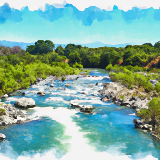
The segment mileage for the Cora Creek to the confluence with San Joaquin River run is approximately 12 miles, with several notable rapids and obstacles along the way. Some of the more challenging rapids include Suicide Falls, Pinball, and S-Turn.
There are specific regulations that must be followed when running this river, including the requirement for a permit from the U.S. Forest Service. Additionally, all boaters must wear a personal flotation device (PFD) at all times, and groups of ten or more must follow a Leave No Trace plan and obtain a special permit.
Overall, the Cora Creek to the confluence with San Joaquin River run is a thrilling and challenging whitewater experience for experienced paddlers. It is important to be aware of the specific regulations and recommended streamflow range before attempting this run.
Plan your run down to the hour
Same weather feed Snoflo's iOS app uses -- updated continuously from NOAA / yr.no. Watch the precipitation column on the meteogram; rain ahead of a run typically lifts flows 12-48 hours later depending on the basin.
Next 5 days, hour by hour
Temperature line with weather symbols on top, snow + rain accumulation as columns, humidity as a dotted line.
5-day forecast table
Every 3 hours, broken out across temperature, snow, rain, humidity, and wind. Each cell is colour-coded relative to the column min/max.
| Time | Condition | Temp (°F) | Snow (in) | Rain (in) | Humidity (%) | Wind (mps) | Wind dir |
|---|---|---|---|---|---|---|---|
| Loading detailed forecast… | |||||||
15-day temperature & precipitation
Daily temperatures, snow, and rain projected over the next two weeks -- the upstream story that drives next week's flows.
Regional streamflow levels
USGS streamgauges around Cora Creek To Confluence With San Joaquin River -- useful for spotting upstream pulses and gauging which tributary is contributing what.
| Streamgauge | Discharge | View |
|---|---|---|
| Mf San Joaquin R Nr Mammoth Lakes Ca | 58 cfs | → |
| Deadman C A Big Springs Nr Crestview Ca | 20 cfs | → |
| Hot C A Flume Nr Mammoth Lakes Ca | 43 cfs | → |
| Nf Willow C Nr Sugar Pine Ca | 416 cfs | → |
| Big C Div Nr Fish Camp Ca | 0 cfs | → |
| Merced R A Happy Isles Bridge Nr Yosemite Ca | 83 cfs | → |
Plan a longer trip
The closest boat launches, other paddle runs, and campgrounds so a day on the water can grow into a full weekend.
Boat launches
- Lake George
- Lake Mary
- Mammoth Pool Rd, California
- Lake Edison Boating Site
- Vermillion Valley Resort
- Silver Lake Resort
Other river runs
- Rainbow Falls To Confluence With North Fork San Joaquin River
- Hemlock Crossing To Confluence With Cora Creek
- Headwaters In Sec 8, T3s, R25 E To Hemlock Crossing
- Rainbow Falls To National Monument Boundary
- Soda Springs Footbridge In Devils Postpile National Monument To Rainbow Falls
Campgrounds
- Granite Creek Campground
- Clover Meadow
- Bowler Group Campground
- Bowler Group Camp
- Lower Jackass Lake Campground
- Reds Meadow Campground
Fishing spots
Whitewater safety
- Check the flow before you run
- Use the linked-gauge card and Regional Flow panel above. Class ratings change with flow -- a Class III at low water can become Class IV+ at high water.
- Know your skill ceiling
- Pick runs comfortably below your ceiling. Cold-water and big-water runs raise the consequences of any mistake.
- Wear the right gear
- Helmet, PFD, drysuit / wetsuit when water is below 60°F. Throw bag, knife, and whistle on your person, not in the boat.
- Scout, set safety, and run with a team
- Scout new rapids on foot, set safety with throw bags above the consequence pool, and run with at least one other competent paddler.
- Respect the river
- Strainers, undercuts, low-head dams, and wood can kill at any class rating. When in doubt, portage.
Set push alerts in the Snoflo app
Save Cora Creek To Confluence With San Joaquin River as a favorite, set a discharge threshold (e.g. "alert me when flow hits 600 cfs"), and the iOS app pushes the moment the linked gauge crosses.
About Cora Creek To Confluence With San Joaquin River
What's the optimal flow for Cora Creek To Confluence With San Joaquin River?
The optimal flow depends on the section and the craft. Check the Run Details panel for the linked gauge and current status.
How fresh is the cfs reading on this page?
The linked USGS streamgauge reports continuously (every 15 minutes); Snoflo refreshes throughout the day. Hover the streamflow sparkline to read individual datapoints.
What's the whitewater class?
See the Run Details panel for the class rating Snoflo tracks for this run. Class ratings change with flow -- a Class III at low water can become Class IV in high water.
Where do I put in / take out?
Tap Directions in the hero above to open driving directions to the put-in. For shuttle planning, check the Nearby Boat Launches panel and the river run operator's site.
Can I get alerts when flows hit the optimal range?
Yes -- alerts are managed in the Snoflo iOS app. Favorite this run, set a discharge threshold, and you'll get a push the moment the gauge crosses.
Other runs near here
Snoflo-tracked paddle runs within driving distance of Cora Creek To Confluence With San Joaquin River.