Langs Crossing Bridge To One-Half Mile West Of Confluence With Fall Creek (Boundary Of Nf And Private Land) River Run
Community Reviews
Been here? Share the conditions.
Reviews, ratings & photos are added in the free Snoflo iOS app — rate a spot, tag the conditions, and your visit is verified by location. Add or manage your reviews from the app.
Langs Crossing Bridge To One-Half Mile West Of Confluence With Fall Creek (Boundary Of Nf And Private Land)
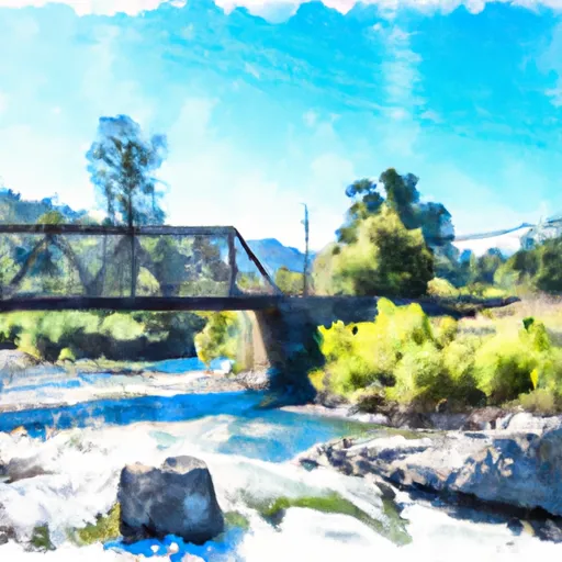
The segment mileage for this run is approximately 11 miles, and it features a variety of challenging rapids and obstacles, including The Chute, a narrow rock channel that requires precise navigation. Other notable rapids include S-Turn, Outlaw, and Upset. Despite the challenges, the scenery is stunning, with lush forests, rugged canyons, and crystal-clear water.
There are specific regulations to the area, including the requirement for all boaters to wear a lifejacket and carry a whistle. Additionally, permits are required for all commercial rafting outfitters operating on this stretch of river, and there are restrictions on group size to minimize the impact on the environment.
Plan your run down to the hour
Same weather feed Snoflo's iOS app uses -- updated continuously from NOAA / yr.no. Watch the precipitation column on the meteogram; rain ahead of a run typically lifts flows 12-48 hours later depending on the basin.
Next 5 days, hour by hour
Temperature line with weather symbols on top, snow + rain accumulation as columns, humidity as a dotted line.
5-day forecast table
Every 3 hours, broken out across temperature, snow, rain, humidity, and wind. Each cell is colour-coded relative to the column min/max.
| Time | Condition | Temp (°F) | Snow (in) | Rain (in) | Humidity (%) | Wind (mps) | Wind dir |
|---|---|---|---|---|---|---|---|
| Loading detailed forecast… | |||||||
15-day temperature & precipitation
Daily temperatures, snow, and rain projected over the next two weeks -- the upstream story that drives next week's flows.
Regional streamflow levels
USGS streamgauges around Langs Crossing Bridge To One-Half Mile West Of Confluence With Fall Creek (Boundary Of Nf And Private Land) -- useful for spotting upstream pulses and gauging which tributary is contributing what.
| Streamgauge | Discharge | View |
|---|---|---|
| N Yuba R Bl Goodyears Bar Ca | 143 cfs | → |
| Little Truckee R Bl Div Dam Nr Sierraville Ca | 3 cfs | → |
| Independence C Nr Truckee Ca | 6 cfs | → |
| Donner C A Donner Lk Nr Truckee Ca | 5 cfs | → |
| Sagehen C Nr Truckee Ca | 2 cfs | → |
| Donner C At Hwy 89 Nr Truckee Ca | 8 cfs | → |
Plan a longer trip
The closest boat launches, other paddle runs, and campgrounds so a day on the water can grow into a full weekend.
Boat launches
- Fuller Lake Boating Site
- Lake Spaulding Road 10260, Nevada City
- Meadow Lake Road Nevada County
- Woodcamp Access Road Nevada County
- Cascade Shores
- Scotts Flat Marina
Other river runs
- One-Half Mile West Of Confluence With Fall Creek To Confluence With Jefferson Creek
- Generation And Giant Gaps (Tadpole To Colfax-Iowa Hill Road)
- Royal Gorge (Soda Springs To Tadpole Creek)
- Headwaters Of North Yuba River (Sec 10, T20n, R13 E) To One-Eighth Mile Downstream Of Confluence With Cherokee Creek
- Chamberlain Falls (Iowa Hill To Yankee Jim)
Campgrounds
- Fuller Lake
- Campsite - Metal Bench
- Bear Valley Group Area
- Donner Summit Area - Lake Spaulding
- Lake Spaulding
- Lake Spaulding Campground
Fishing spots
Parks
Whitewater safety
- Check the flow before you run
- Use the linked-gauge card and Regional Flow panel above. Class ratings change with flow -- a Class III at low water can become Class IV+ at high water.
- Know your skill ceiling
- Pick runs comfortably below your ceiling. Cold-water and big-water runs raise the consequences of any mistake.
- Wear the right gear
- Helmet, PFD, drysuit / wetsuit when water is below 60°F. Throw bag, knife, and whistle on your person, not in the boat.
- Scout, set safety, and run with a team
- Scout new rapids on foot, set safety with throw bags above the consequence pool, and run with at least one other competent paddler.
- Respect the river
- Strainers, undercuts, low-head dams, and wood can kill at any class rating. When in doubt, portage.
Set push alerts in the Snoflo app
Save Langs Crossing Bridge To One-Half Mile West Of Confluence With Fall Creek (Boundary Of Nf And Private Land) as a favorite, set a discharge threshold (e.g. "alert me when flow hits 600 cfs"), and the iOS app pushes the moment the linked gauge crosses.
About Langs Crossing Bridge To One-Half Mile West Of Confluence With Fall Creek (Boundary Of Nf And Private Land)
What's the optimal flow for Langs Crossing Bridge To One-Half Mile West Of Confluence With Fall Creek (Boundary Of Nf And Private Land)?
The optimal flow depends on the section and the craft. Check the Run Details panel for the linked gauge and current status.
How fresh is the cfs reading on this page?
The linked USGS streamgauge reports continuously (every 15 minutes); Snoflo refreshes throughout the day. Hover the streamflow sparkline to read individual datapoints.
What's the whitewater class?
See the Run Details panel for the class rating Snoflo tracks for this run. Class ratings change with flow -- a Class III at low water can become Class IV in high water.
Where do I put in / take out?
Tap Directions in the hero above to open driving directions to the put-in. For shuttle planning, check the Nearby Boat Launches panel and the river run operator's site.
Can I get alerts when flows hit the optimal range?
Yes -- alerts are managed in the Snoflo iOS app. Favorite this run, set a discharge threshold, and you'll get a push the moment the gauge crosses.
Other runs near here
Snoflo-tracked paddle runs within driving distance of Langs Crossing Bridge To One-Half Mile West Of Confluence With Fall Creek (Boundary Of Nf And Private Land).