Palm Canyon River Run
Community Reviews
Been here? Share the conditions.
Reviews, ratings & photos are added in the free Snoflo iOS app — rate a spot, tag the conditions, and your visit is verified by location. Add or manage your reviews from the app.
Palm Canyon
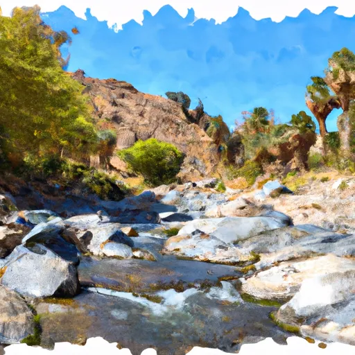
One of the most notable rapids in this section is "Ledge Drop," which is a steep drop with a large boulder in the middle of the channel. Other notable rapids include "Little San Bernardino" and "Pinball." There are also several smaller rapids and obstacles throughout the run.
It is important for visitors to note that the Palm Canyon section of the Whitewater River is located within the San Bernardino National Forest and is subject to specific regulations. Visitors must obtain a permit from the forest service before accessing the river, and all visitors must follow Leave No Trace principles to preserve the natural environment. Additionally, visitors should be aware of potential hazards from flash floods and sudden rises in water levels.
Overall, the Palm Canyon section of the Whitewater River offers an exhilarating whitewater experience for intermediate paddlers and is a must-visit destination for those looking for a challenging and scenic river run in California.
Plan your run down to the hour
Same weather feed Snoflo's iOS app uses -- updated continuously from NOAA / yr.no. Watch the precipitation column on the meteogram; rain ahead of a run typically lifts flows 12-48 hours later depending on the basin.
Next 5 days, hour by hour
Temperature line with weather symbols on top, snow + rain accumulation as columns, humidity as a dotted line.
5-day forecast table
Every 3 hours, broken out across temperature, snow, rain, humidity, and wind. Each cell is colour-coded relative to the column min/max.
| Time | Condition | Temp (°F) | Snow (in) | Rain (in) | Humidity (%) | Wind (mps) | Wind dir |
|---|---|---|---|---|---|---|---|
| Loading detailed forecast… | |||||||
15-day temperature & precipitation
Daily temperatures, snow, and rain projected over the next two weeks -- the upstream story that drives next week's flows.
Regional streamflow levels
USGS streamgauges around Palm Canyon -- useful for spotting upstream pulses and gauging which tributary is contributing what.
| Streamgauge | Discharge | View |
|---|---|---|
| Palm Cyn C Nr Palm Springs Ca | · | → |
| Murray Cyn C Nr Palm Springs Ca | · | → |
| Andreas C Nr Palm Springs Ca | 0 cfs | → |
| Whitewater R A Rancho Mirage Ca | · | → |
| Deep C Nr Palm Desert Ca | · | → |
| Palm Cyn Wash Nr Cathedral City Ca | · | → |
Plan a longer trip
The closest boat launches, other paddle runs, and campgrounds so a day on the water can grow into a full weekend.
Boat launches
Other river runs
- Mission Creek
- West Fork Mission Creek
- South Fork - Wilderness Boundary/Sfdiversion Dam To Confluence With Mainstream
Campgrounds
- Sky Ridge
- Pinyon Flat Campground
- Pinyon Flat
- Pine Springs Ranch - Christian Camp & Conference Center
- Ribbonwood Equestrian Campground
- Ribbonwood Equestrian
Fishing spots
- Lake Hemet
- Lake Hemet Day Use Area
- Foster Lake
- Strawberry Creek
- Fuller Mill Creek
- Lake Fulmor Day Use Area
Parks
Whitewater safety
- Check the flow before you run
- Use the linked-gauge card and Regional Flow panel above. Class ratings change with flow -- a Class III at low water can become Class IV+ at high water.
- Know your skill ceiling
- Pick runs comfortably below your ceiling. Cold-water and big-water runs raise the consequences of any mistake.
- Wear the right gear
- Helmet, PFD, drysuit / wetsuit when water is below 60°F. Throw bag, knife, and whistle on your person, not in the boat.
- Scout, set safety, and run with a team
- Scout new rapids on foot, set safety with throw bags above the consequence pool, and run with at least one other competent paddler.
- Respect the river
- Strainers, undercuts, low-head dams, and wood can kill at any class rating. When in doubt, portage.
Set push alerts in the Snoflo app
Save Palm Canyon as a favorite, set a discharge threshold (e.g. "alert me when flow hits 600 cfs"), and the iOS app pushes the moment the linked gauge crosses.
About Palm Canyon
What's the optimal flow for Palm Canyon?
The optimal flow depends on the section and the craft. Check the Run Details panel for the linked gauge and current status.
How fresh is the cfs reading on this page?
The linked USGS streamgauge reports continuously (every 15 minutes); Snoflo refreshes throughout the day. Hover the streamflow sparkline to read individual datapoints.
What's the whitewater class?
See the Run Details panel for the class rating Snoflo tracks for this run. Class ratings change with flow -- a Class III at low water can become Class IV in high water.
Where do I put in / take out?
Tap Directions in the hero above to open driving directions to the put-in. For shuttle planning, check the Nearby Boat Launches panel and the river run operator's site.
Can I get alerts when flows hit the optimal range?
Yes -- alerts are managed in the Snoflo iOS app. Favorite this run, set a discharge threshold, and you'll get a push the moment the gauge crosses.
Other runs near here
Snoflo-tracked paddle runs within driving distance of Palm Canyon.