Santa Margarita River River Run
Community Reviews
Been here? Share the conditions.
Reviews, ratings & photos are added in the free Snoflo iOS app — rate a spot, tag the conditions, and your visit is verified by location. Add or manage your reviews from the app.
Santa Margarita River
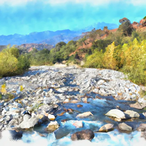
The segment mileage of the Santa Margarita River run is approximately 10 miles, starting at the Tenaja Falls trailhead and ending at the bridge near the De Luz Housing area. Along the way, rafters will encounter several challenging rapids, including Tenaja Falls, Upper and Lower Santa Margarita Falls, and the Narrows. These rapids are known for their technical difficulty, steep drops, and tight turns.
To ensure safety and preserve the natural environment, there are specific regulations in place for the Santa Margarita River. Rafting is only allowed during certain times of the year, typically between December and May when water levels are highest. Additionally, all rafters must wear a lifejacket and helmet, and no alcohol is allowed on the river.
Overall, the Santa Margarita River run offers a thrilling and challenging whitewater rafting experience for those who are up for the adventure. However, it is important to follow all regulations and safety guidelines to ensure a safe and enjoyable trip.
Plan your run down to the hour
Same weather feed Snoflo's iOS app uses -- updated continuously from NOAA / yr.no. Watch the precipitation column on the meteogram; rain ahead of a run typically lifts flows 12-48 hours later depending on the basin.
Next 5 days, hour by hour
Temperature line with weather symbols on top, snow + rain accumulation as columns, humidity as a dotted line.
5-day forecast table
Every 3 hours, broken out across temperature, snow, rain, humidity, and wind. Each cell is colour-coded relative to the column min/max.
| Time | Condition | Temp (°F) | Snow (in) | Rain (in) | Humidity (%) | Wind (mps) | Wind dir |
|---|---|---|---|---|---|---|---|
| Loading detailed forecast… | |||||||
15-day temperature & precipitation
Daily temperatures, snow, and rain projected over the next two weeks -- the upstream story that drives next week's flows.
Regional streamflow levels
USGS streamgauges around Santa Margarita River -- useful for spotting upstream pulses and gauging which tributary is contributing what.
| Streamgauge | Discharge | View |
|---|---|---|
| Santa Margarita R Nr Temecula Ca | 3 cfs | → |
| Santa Gertrudis C Nr Temecula Ca | · | → |
| Rainbow C Nr Fallbrook Ca | · | → |
| Warm Springs C Nr Murrieta Ca | · | → |
| Santa Margarita R A Fpud Sump Nr Fallbrook Ca | 1 cfs | → |
| Sandia C Nr Fallbrook Ca | 0 cfs | → |
Plan a longer trip
The closest boat launches, other paddle runs, and campgrounds so a day on the water can grow into a full weekend.
Boat launches
- Warren Road 37701, Temecula
- Lake Skinner Marina Boat #1
- Vail Lake Boat Ramp
- Goetz Road Riverside County
- Vacation Drive 28736, Canyon Lake
Other river runs
- Devil Canyon Tributary To San Mateo Creek
- San Mateo Wilderness Boundary To Nf Boundary With Camp Pendleton
- Confluence Of Fry And Iron Spring Creeks (E1/2, Sec 3, T10s,R1e To Se1/4 Sec 16, T10s, R2e
- Forest Boundary, Above Zoo Creek Below Spillway (S1/2, Sec 3, T11s, R2e) To La Jolla Indian Reservation Boundary (N1/2, Sec 31, T10s, R2e)
Campgrounds
Fishing spots
Whitewater safety
- Check the flow before you run
- Use the linked-gauge card and Regional Flow panel above. Class ratings change with flow -- a Class III at low water can become Class IV+ at high water.
- Know your skill ceiling
- Pick runs comfortably below your ceiling. Cold-water and big-water runs raise the consequences of any mistake.
- Wear the right gear
- Helmet, PFD, drysuit / wetsuit when water is below 60°F. Throw bag, knife, and whistle on your person, not in the boat.
- Scout, set safety, and run with a team
- Scout new rapids on foot, set safety with throw bags above the consequence pool, and run with at least one other competent paddler.
- Respect the river
- Strainers, undercuts, low-head dams, and wood can kill at any class rating. When in doubt, portage.
Set push alerts in the Snoflo app
Save Santa Margarita River as a favorite, set a discharge threshold (e.g. "alert me when flow hits 600 cfs"), and the iOS app pushes the moment the linked gauge crosses.
About Santa Margarita River
What's the optimal flow for Santa Margarita River?
The optimal flow depends on the section and the craft. Check the Run Details panel for the linked gauge and current status.
How fresh is the cfs reading on this page?
The linked USGS streamgauge reports continuously (every 15 minutes); Snoflo refreshes throughout the day. Hover the streamflow sparkline to read individual datapoints.
What's the whitewater class?
See the Run Details panel for the class rating Snoflo tracks for this run. Class ratings change with flow -- a Class III at low water can become Class IV in high water.
Where do I put in / take out?
Tap Directions in the hero above to open driving directions to the put-in. For shuttle planning, check the Nearby Boat Launches panel and the river run operator's site.
Can I get alerts when flows hit the optimal range?
Yes -- alerts are managed in the Snoflo iOS app. Favorite this run, set a discharge threshold, and you'll get a push the moment the gauge crosses.
Other runs near here
Snoflo-tracked paddle runs within driving distance of Santa Margarita River.