Devil Canyon Tributary To San Mateo Creek River Run
Community Reviews
Been here? Share the conditions.
Reviews, ratings & photos are added in the free Snoflo iOS app — rate a spot, tag the conditions, and your visit is verified by location. Add or manage your reviews from the app.
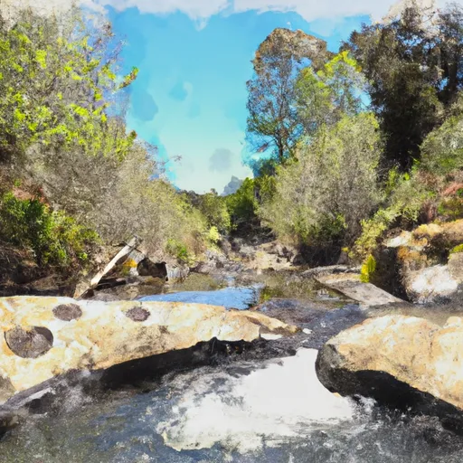
Devil Canyon Tributary To San Mateo Creek
The Devil Canyon Tributary to San Mateo Creek is rated as a class IV-V run, which means that it is suitable for experienced and expert paddlers only. The rapids on this run include tight drops and steep chutes, making it a challenging run even for experienced paddlers. Some of the specific rapids and obstacles to watch out for include the "Killer Bee," "Kamikaze," and "Toad's Tongue."
There are specific regulations that apply to this area. The use of personal flotation devices (PFDs) is mandatory, and all paddlers must have the necessary safety equipment, such as a helmet and a throw rope. Additionally, paddlers are required to obtain a permit from the Cleveland National Forest in order to access the river.
In conclusion, the Devil Canyon Tributary to San Mateo Creek is a challenging and exciting whitewater river run in California. The ideal streamflow range is between 400 and 1500 cfs, and the run is rated as a class IV-V. Paddlers must be experienced and equipped with the necessary safety equipment, and a permit is required to access the river.
Plan your run down to the hour
Same weather feed Snoflo's iOS app uses -- updated continuously from NOAA / yr.no. Watch the precipitation column on the meteogram; rain ahead of a run typically lifts flows 12-48 hours later depending on the basin.
Next 5 days, hour by hour
Temperature line with weather symbols on top, snow + rain accumulation as columns, humidity as a dotted line.
5-day forecast table
Every 3 hours, broken out across temperature, snow, rain, humidity, and wind. Each cell is colour-coded relative to the column min/max.
| Time | Condition | Temp (°F) | Snow (in) | Rain (in) | Humidity (%) | Wind (mps) | Wind dir |
|---|---|---|---|---|---|---|---|
| Loading detailed forecast… | |||||||
15-day temperature & precipitation
Daily temperatures, snow, and rain projected over the next two weeks -- the upstream story that drives next week's flows.
Regional streamflow levels
USGS streamgauges around Devil Canyon Tributary To San Mateo Creek -- useful for spotting upstream pulses and gauging which tributary is contributing what.
| Streamgauge | Discharge | View |
|---|---|---|
| De Luz C Nr De Luz Ca | · | → |
| San Mateo C Nr San Clemente Ca | 166 cfs | → |
| Sandia C Nr Fallbrook Ca | 0 cfs | → |
| Fallbrook C Nr Fallbrook Ca | · | → |
| Santa Margarita R A Fpud Sump Nr Fallbrook Ca | 1 cfs | → |
| Oneill Lk Spill Ch Nr Fallbrook Ca | · | → |
Plan a longer trip
The closest boat launches, other paddle runs, and campgrounds so a day on the water can grow into a full weekend.
Boat launches
- Lake Elsinore West Marina & Rv Park
- Lake Elsinore Recreation Area
- Oceanside Harbor
- Goetz Road Riverside County
- Vacation Drive 28736, Canyon Lake
- Dana Point
Other river runs
- Santa Margarita River
- San Mateo Wilderness Boundary To Nf Boundary With Camp Pendleton
- Confluence Of Fry And Iron Spring Creeks (E1/2, Sec 3, T10s,R1e To Se1/4 Sec 16, T10s, R2e
- Forest Boundary, Above Zoo Creek Below Spillway (S1/2, Sec 3, T11s, R2e) To La Jolla Indian Reservation Boundary (N1/2, Sec 31, T10s, R2e)
Campgrounds
- Fisherman's Camp
- Lake Oneill Military
- Wildomar Campground
- Wildomar
- Upper San Juan
- Upper San Juan Campground
Fishing spots
Whitewater safety
- Check the flow before you run
- Use the linked-gauge card and Regional Flow panel above. Class ratings change with flow -- a Class III at low water can become Class IV+ at high water.
- Know your skill ceiling
- Pick runs comfortably below your ceiling. Cold-water and big-water runs raise the consequences of any mistake.
- Wear the right gear
- Helmet, PFD, drysuit / wetsuit when water is below 60°F. Throw bag, knife, and whistle on your person, not in the boat.
- Scout, set safety, and run with a team
- Scout new rapids on foot, set safety with throw bags above the consequence pool, and run with at least one other competent paddler.
- Respect the river
- Strainers, undercuts, low-head dams, and wood can kill at any class rating. When in doubt, portage.
Set push alerts in the Snoflo app
Save Devil Canyon Tributary To San Mateo Creek as a favorite, set a discharge threshold (e.g. "alert me when flow hits 600 cfs"), and the iOS app pushes the moment the linked gauge crosses.
About Devil Canyon Tributary To San Mateo Creek
What's the optimal flow for Devil Canyon Tributary To San Mateo Creek?
The optimal flow depends on the section and the craft. Check the Run Details panel for the linked gauge and current status.
How fresh is the cfs reading on this page?
The linked USGS streamgauge reports continuously (every 15 minutes); Snoflo refreshes throughout the day. Hover the streamflow sparkline to read individual datapoints.
What's the whitewater class?
See the Run Details panel for the class rating Snoflo tracks for this run. Class ratings change with flow -- a Class III at low water can become Class IV in high water.
Where do I put in / take out?
Tap Directions in the hero above to open driving directions to the put-in. For shuttle planning, check the Nearby Boat Launches panel and the river run operator's site.
Can I get alerts when flows hit the optimal range?
Yes -- alerts are managed in the Snoflo iOS app. Favorite this run, set a discharge threshold, and you'll get a push the moment the gauge crosses.
Other runs near here
Snoflo-tracked paddle runs within driving distance of Devil Canyon Tributary To San Mateo Creek.