Shasta River River Run
Community Reviews
Been here? Share the conditions.
Reviews, ratings & photos are added in the free Snoflo iOS app — rate a spot, tag the conditions, and your visit is verified by location. Add or manage your reviews from the app.
Shasta River
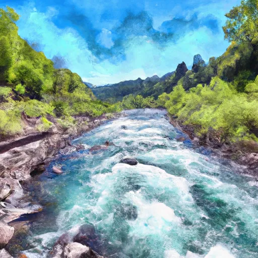
The Shasta River offers a variety of rapids and obstacles that challenge paddlers, including the China Rapid, the Upper and Lower Falls, and the Upper Grassy Knoll. The China Rapid is a Class III rapid that requires precise maneuvering and navigating around rocks and boulders. The Upper and Lower Falls are Class II rapids that offer an exciting drop and splash experience for paddlers. The Upper Grassy Knoll offers a Class II technical challenge that requires paddlers to navigate through tight channels and swirling currents.
There are specific regulations that paddlers must follow when navigating the Whitewater River Run Shasta River. All paddlers must wear a personal flotation device (PFD) at all times, and it is recommended that paddlers wear a helmet as well. Paddlers must also respect private property along the riverbanks and avoid littering.
In conclusion, the Whitewater River Run Shasta River is an exciting river that offers a range of challenges for paddlers. The ideal streamflow range, class rating, segment mileage, specific river rapids/obstacles, and specific regulations make it a must-visit location for kayaking and rafting enthusiasts.
Plan your run down to the hour
Same weather feed Snoflo's iOS app uses -- updated continuously from NOAA / yr.no. Watch the precipitation column on the meteogram; rain ahead of a run typically lifts flows 12-48 hours later depending on the basin.
Next 5 days, hour by hour
Temperature line with weather symbols on top, snow + rain accumulation as columns, humidity as a dotted line.
5-day forecast table
Every 3 hours, broken out across temperature, snow, rain, humidity, and wind. Each cell is colour-coded relative to the column min/max.
| Time | Condition | Temp (°F) | Snow (in) | Rain (in) | Humidity (%) | Wind (mps) | Wind dir |
|---|---|---|---|---|---|---|---|
| Loading detailed forecast… | |||||||
15-day temperature & precipitation
Daily temperatures, snow, and rain projected over the next two weeks -- the upstream story that drives next week's flows.
Regional streamflow levels
USGS streamgauges around Shasta River -- useful for spotting upstream pulses and gauging which tributary is contributing what.
| Streamgauge | Discharge | View |
|---|---|---|
| Shasta R Nr Yreka Ca | 52 cfs | → |
| Shasta R Nr Montague Ca | 59 cfs | → |
| Klamath R Bl Iron Gate Dam Ca | 890 cfs | → |
| Scott R Nr Fort Jones Ca | 30 cfs | → |
| West Fork Ashland Creek Near Ashland | 2 cfs | → |
| East Fork Ashland Creek Near Ashland | 2 cfs | → |
Plan a longer trip
The closest boat launches, other paddle runs, and campgrounds so a day on the water can grow into a full weekend.
Boat launches
- A. Ash Creek River Access
- B. Cayuse River Access
- C. Skeahan Bar River Access
- D. Gottville River Access
- Iron Gate Reservoir (Long Gulch)
- Iron Gate Reservoir (Mirror Cove)
Other river runs
- Iron Gate Dam To Happy Camp
- Little Applegate River
- Headwaters In Marble Mtn. Wilderness To Wilderness Boundary
- Confluence With Rancheria Creek To Forest Road 46n24x
- Headwaters In Marble Mtn. Wilderness To Confluence With Fish Creek
Campgrounds
Fishing spots
Parks
Whitewater safety
- Check the flow before you run
- Use the linked-gauge card and Regional Flow panel above. Class ratings change with flow -- a Class III at low water can become Class IV+ at high water.
- Know your skill ceiling
- Pick runs comfortably below your ceiling. Cold-water and big-water runs raise the consequences of any mistake.
- Wear the right gear
- Helmet, PFD, drysuit / wetsuit when water is below 60°F. Throw bag, knife, and whistle on your person, not in the boat.
- Scout, set safety, and run with a team
- Scout new rapids on foot, set safety with throw bags above the consequence pool, and run with at least one other competent paddler.
- Respect the river
- Strainers, undercuts, low-head dams, and wood can kill at any class rating. When in doubt, portage.
Set push alerts in the Snoflo app
Save Shasta River as a favorite, set a discharge threshold (e.g. "alert me when flow hits 600 cfs"), and the iOS app pushes the moment the linked gauge crosses.
About Shasta River
What's the optimal flow for Shasta River?
The optimal flow depends on the section and the craft. Check the Run Details panel for the linked gauge and current status.
How fresh is the cfs reading on this page?
The linked USGS streamgauge reports continuously (every 15 minutes); Snoflo refreshes throughout the day. Hover the streamflow sparkline to read individual datapoints.
What's the whitewater class?
See the Run Details panel for the class rating Snoflo tracks for this run. Class ratings change with flow -- a Class III at low water can become Class IV in high water.
Where do I put in / take out?
Tap Directions in the hero above to open driving directions to the put-in. For shuttle planning, check the Nearby Boat Launches panel and the river run operator's site.
Can I get alerts when flows hit the optimal range?
Yes -- alerts are managed in the Snoflo iOS app. Favorite this run, set a discharge threshold, and you'll get a push the moment the gauge crosses.
Other runs near here
Snoflo-tracked paddle runs within driving distance of Shasta River.