North Fork Cottonwood Creek River Run
Community Reviews
Been here? Share the conditions.
Reviews, ratings & photos are added in the free Snoflo iOS app — rate a spot, tag the conditions, and your visit is verified by location. Add or manage your reviews from the app.
North Fork Cottonwood Creek
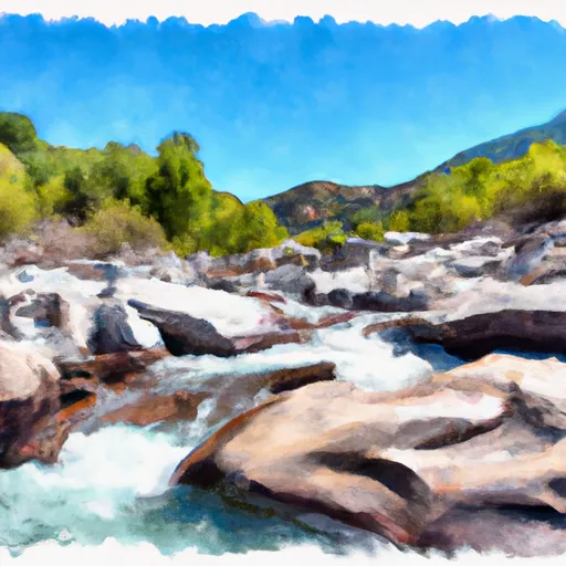
The North Fork Cottonwood Creek is known for its challenging rapids and obstacles such as S-Turn, Ledges, and the Toaster. These rapids require technical paddling skills and experience to navigate. The river also features steep drops and narrow canyons, which add to the excitement of the run.
In terms of regulations, it is important to note that the North Fork Cottonwood Creek is located within the Eldorado National Forest. Therefore, visitors must adhere to the rules and regulations set forth by the Forest Service. These regulations include obtaining a permit for overnight camping, packing out all trash, and following Leave No Trace principles.
Overall, the North Fork Cottonwood Creek is a challenging and exciting whitewater river run that requires experience and technical skills to navigate. With its stunning scenery and thrilling rapids, it is a must-visit destination for any avid kayaker or whitewater enthusiast.
Plan your run down to the hour
Same weather feed Snoflo's iOS app uses -- updated continuously from NOAA / yr.no. Watch the precipitation column on the meteogram; rain ahead of a run typically lifts flows 12-48 hours later depending on the basin.
Next 5 days, hour by hour
Temperature line with weather symbols on top, snow + rain accumulation as columns, humidity as a dotted line.
5-day forecast table
Every 3 hours, broken out across temperature, snow, rain, humidity, and wind. Each cell is colour-coded relative to the column min/max.
| Time | Condition | Temp (°F) | Snow (in) | Rain (in) | Humidity (%) | Wind (mps) | Wind dir |
|---|---|---|---|---|---|---|---|
| Loading detailed forecast… | |||||||
15-day temperature & precipitation
Daily temperatures, snow, and rain projected over the next two weeks -- the upstream story that drives next week's flows.
Regional streamflow levels
USGS streamgauges around North Fork Cottonwood Creek -- useful for spotting upstream pulses and gauging which tributary is contributing what.
| Streamgauge | Discharge | View |
|---|---|---|
| Clear C Nr Igo Ca | 135 cfs | → |
| Sacramento R A Keswick Ca | 13,000 cfs | → |
| Indian C Nr Douglas City Ca | 6 cfs | → |
| Grass Valley C Nr Lewiston Ca | 18 cfs | → |
| Trinity R A Lewiston Ca | 450 cfs | → |
| Trinity R Bl Limekiln Gulch Nr Douglas City Ca | 464 cfs | → |
Plan a longer trip
The closest boat launches, other paddle runs, and campgrounds so a day on the water can grow into a full weekend.
Boat launches
- Brandy Creek Marina
- Oak Bottom Marina
- Whiskey Creek
- Keswick Boat Ramp
- Clear Creek Road 17501-17987, Redding
- Bucktail Hole
Other river runs
- Clear Creek
- Middle Fork Cottonwood Creek
- Beegum Creek
- West Sec Line Of Sec 6, T28n,R9/10w To Nf Boundary With Blm
Campgrounds
- Sheep Creek Campground
- Brandy Creek
- Peltier Bridge Primitive Campground
- Peltier Campground
- Boulder Creek Backcounty Camp
- Horse Camp Primitive Campground
Fishing spots
Whitewater safety
- Check the flow before you run
- Use the linked-gauge card and Regional Flow panel above. Class ratings change with flow -- a Class III at low water can become Class IV+ at high water.
- Know your skill ceiling
- Pick runs comfortably below your ceiling. Cold-water and big-water runs raise the consequences of any mistake.
- Wear the right gear
- Helmet, PFD, drysuit / wetsuit when water is below 60°F. Throw bag, knife, and whistle on your person, not in the boat.
- Scout, set safety, and run with a team
- Scout new rapids on foot, set safety with throw bags above the consequence pool, and run with at least one other competent paddler.
- Respect the river
- Strainers, undercuts, low-head dams, and wood can kill at any class rating. When in doubt, portage.
Set push alerts in the Snoflo app
Save North Fork Cottonwood Creek as a favorite, set a discharge threshold (e.g. "alert me when flow hits 600 cfs"), and the iOS app pushes the moment the linked gauge crosses.
About North Fork Cottonwood Creek
What's the optimal flow for North Fork Cottonwood Creek?
The optimal flow depends on the section and the craft. Check the Run Details panel for the linked gauge and current status.
How fresh is the cfs reading on this page?
The linked USGS streamgauge reports continuously (every 15 minutes); Snoflo refreshes throughout the day. Hover the streamflow sparkline to read individual datapoints.
What's the whitewater class?
See the Run Details panel for the class rating Snoflo tracks for this run. Class ratings change with flow -- a Class III at low water can become Class IV in high water.
Where do I put in / take out?
Tap Directions in the hero above to open driving directions to the put-in. For shuttle planning, check the Nearby Boat Launches panel and the river run operator's site.
Can I get alerts when flows hit the optimal range?
Yes -- alerts are managed in the Snoflo iOS app. Favorite this run, set a discharge threshold, and you'll get a push the moment the gauge crosses.
Other runs near here
Snoflo-tracked paddle runs within driving distance of North Fork Cottonwood Creek.