Headwaters To Ends 0.5 Miles Away From Trail Ridge Road River Run
Community Reviews
Been here? Share the conditions.
Reviews, ratings & photos are added in the free Snoflo iOS app — rate a spot, tag the conditions, and your visit is verified by location. Add or manage your reviews from the app.
Headwaters To Ends 0.5 Miles Away From Trail Ridge Road
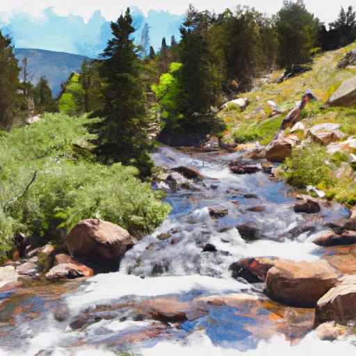
The specific rapids and obstacles on this section include the S-Turn and Tunnel Falls. The S-Turn is a series of bends in the river that create challenging eddy lines and waves. Tunnel Falls is a steep, technical drop that requires precise navigation. Additionally, the river runs through narrow canyons that add to the excitement of the run.
To ensure safety, there are specific regulations in place for this section of the Whitewater River. Paddlers are required to wear life jackets and helmets at all times. Additionally, there are restrictions on the number of paddlers that can be on the river at any given time.
Overall, the Whitewater River Run is a thrilling destination for experienced paddlers. It offers challenging rapids and technical sections in a beautiful natural setting. As with any whitewater adventure, safety should be the top priority, and paddlers should be aware of the ideal streamflow range and class rating before attempting the run.
Plan your run down to the hour
Same weather feed Snoflo's iOS app uses -- updated continuously from NOAA / yr.no. Watch the precipitation column on the meteogram; rain ahead of a run typically lifts flows 12-48 hours later depending on the basin.
Next 5 days, hour by hour
Temperature line with weather symbols on top, snow + rain accumulation as columns, humidity as a dotted line.
5-day forecast table
Every 3 hours, broken out across temperature, snow, rain, humidity, and wind. Each cell is colour-coded relative to the column min/max.
| Time | Condition | Temp (°F) | Snow (in) | Rain (in) | Humidity (%) | Wind (mps) | Wind dir |
|---|---|---|---|---|---|---|---|
| Loading detailed forecast… | |||||||
15-day temperature & precipitation
Daily temperatures, snow, and rain projected over the next two weeks -- the upstream story that drives next week's flows.
Regional streamflow levels
USGS streamgauges around Headwaters To Ends 0.5 Miles Away From Trail Ridge Road -- useful for spotting upstream pulses and gauging which tributary is contributing what.
| Streamgauge | Discharge | View |
|---|---|---|
| Grand Lake Outlet Blw Chipmunk Ln At Grand Lk | 193 cfs | → |
| Colorado R Below Baker Gulch | 23 cfs | → |
| Colorado River Bl Shadow Mountain Reservoir | 50 cfs | → |
| Colorado River Below Lake Granby | 114 cfs | → |
| Willow Creek Below Willow Creek Reservoir | 7 cfs | → |
| Colorado River Near Granby | 108 cfs | → |
Plan a longer trip
The closest boat launches, other paddle runs, and campgrounds so a day on the water can grow into a full weekend.
Boat launches
- Hilltop Boating Site
- Boat Launch Grand Lake
- Grand County
- Us 34 Grand County
- Cr 6 Grand County
- Willow Creek Boating Site
Other river runs
- Begins 0.5 Miles Away From Trail Ridge Road To Ends Where River Segment Exits Rocky Mountain National Park
- Headwaters To Ends 0.5 Miles Upstream From End Of Fern Lake Road
- Headwaters To Fan Lake
- Begins 0.5 Miles Upstream From End Of Fern Lake Road To Eastern Boundary Of Rocky Mountain National Park
- Headwaters To Ends 0.5 Miles Upstream From End Of County Hwy 115
Campgrounds
- Highway 4 Pullout Dispersed Camping
- Green Ridge
- Green Ridge Campground
- Cutthroat Bay Group Campground
- Porcupine Campsite East
- Porcupine Campsite West
Fishing spots
- Shadow Mountain Reservoir
- Pettingell Lake - Rmnp
- Haynach Lakes & Drainage - Rmnp
- Lone Pine Lake - Rmnp
- Lake Nanita & Drainage - Rmnp
- Timber Lake - Rmnp
Whitewater safety
- Check the flow before you run
- Use the linked-gauge card and Regional Flow panel above. Class ratings change with flow -- a Class III at low water can become Class IV+ at high water.
- Know your skill ceiling
- Pick runs comfortably below your ceiling. Cold-water and big-water runs raise the consequences of any mistake.
- Wear the right gear
- Helmet, PFD, drysuit / wetsuit when water is below 60°F. Throw bag, knife, and whistle on your person, not in the boat.
- Scout, set safety, and run with a team
- Scout new rapids on foot, set safety with throw bags above the consequence pool, and run with at least one other competent paddler.
- Respect the river
- Strainers, undercuts, low-head dams, and wood can kill at any class rating. When in doubt, portage.
Set push alerts in the Snoflo app
Save Headwaters To Ends 0.5 Miles Away From Trail Ridge Road as a favorite, set a discharge threshold (e.g. "alert me when flow hits 600 cfs"), and the iOS app pushes the moment the linked gauge crosses.
About Headwaters To Ends 0.5 Miles Away From Trail Ridge Road
What's the optimal flow for Headwaters To Ends 0.5 Miles Away From Trail Ridge Road?
The optimal flow depends on the section and the craft. Check the Run Details panel for the linked gauge and current status.
How fresh is the cfs reading on this page?
The linked USGS streamgauge reports continuously (every 15 minutes); Snoflo refreshes throughout the day. Hover the streamflow sparkline to read individual datapoints.
What's the whitewater class?
See the Run Details panel for the class rating Snoflo tracks for this run. Class ratings change with flow -- a Class III at low water can become Class IV in high water.
Where do I put in / take out?
Tap Directions in the hero above to open driving directions to the put-in. For shuttle planning, check the Nearby Boat Launches panel and the river run operator's site.
Can I get alerts when flows hit the optimal range?
Yes -- alerts are managed in the Snoflo iOS app. Favorite this run, set a discharge threshold, and you'll get a push the moment the gauge crosses.
Other runs near here
Snoflo-tracked paddle runs within driving distance of Headwaters To Ends 0.5 Miles Away From Trail Ridge Road.