Jicarilla Apache Reservation Boundary To Nf Boundary river run
Community Reviews
Been here? Share the conditions.
Reviews, ratings & photos are added in the free Snoflo iOS app — rate a spot, tag the conditions, and your visit is verified by location. Add or manage your reviews from the app.
Jicarilla Apache Reservation Boundary To Nf Boundary
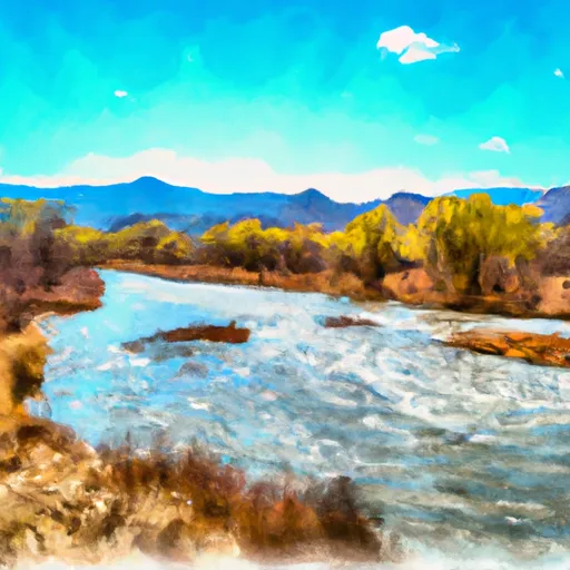
The class rating for this segment is between III and IV, with several challenging rapids and obstacles to navigate. Some notable rapids include "Mushroom," "Upper and Lower Eight Mile," and "Widowmaker." Kayakers and rafters can expect to encounter large boulders, steep drops, and strong currents throughout the run.
This segment spans a total of 18 miles and boasts beautiful scenery and wildlife sightings along the way. However, it is important to note that this section of the river is only accessible through the Jicarilla Apache Nation and requires a permit to access.
Additionally, there are several regulations in place to protect the area and ensure safety for all visitors. This includes a strict limit on group size, no alcohol or drugs allowed, and a requirement for all participants to wear a personal flotation device. Overall, the Whitewater River Run on the Jicarilla Apache Reservation Boundary to NF Boundary offers a thrilling and scenic adventure for experienced kayakers and rafters.
Plan your run down to the hour
Same weather feed Snoflo's iOS app uses -- updated continuously from NOAA / yr.no. Watch the precipitation column on the meteogram; rain ahead of a run typically lifts flows 12-48 hours later depending on the basin.
Next 5 days, hour by hour
Temperature line with weather symbols on top, snow + rain accumulation as columns, humidity as a dotted line.
5-day forecast table
Every 3 hours, broken out across temperature, snow, rain, humidity, and wind. Each cell is colour-coded relative to the column min/max.
| Time | Condition | Temp (°F) | Snow (in) | Rain (in) | Humidity (%) | Wind (mps) | Wind dir |
|---|---|---|---|---|---|---|---|
| Loading detailed forecast… | |||||||
15-day temperature & precipitation
Daily temperatures, snow, and rain projected over the next two weeks -- the upstream story that drives next week's flows.
Regional streamflow levels
USGS streamgauges around Jicarilla Apache Reservation Boundary To Nf Boundary -- useful for spotting upstream pulses and gauging which tributary is contributing what.
| Streamgauge | Discharge | View |
|---|---|---|
| San Juan River Near Carracas | 33 cfs | → |
| Piedra River Near Arboles | · | → |
| Spring Creek At La Boca | 40 cfs | → |
| Los Pinos River At La Boca | 81 cfs | → |
| San Juan River Near Archuleta | 996 cfs | → |
| Los Pinos River Near Ignacio | 1 cfs | → |
Plan a longer trip
The closest boat launches, other paddle runs, and campgrounds so a day on the water can grow into a full weekend.
Boat launches
- R 982 Archuleta County
- Navajo State Park
- Navajo Lake State Park - Sims Marina
- Navajo Lake State Park - Navajo Lake Marina
- Navajo Lake State Park
Whitewater safety
- Check the flow before you run
- Use the linked-gauge card and Regional Flow panel above. Class ratings change with flow -- a Class III at low water can become Class IV+ at high water.
- Know your skill ceiling
- Pick runs comfortably below your ceiling. Cold-water and big-water runs raise the consequences of any mistake.
- Wear the right gear
- Helmet, PFD, drysuit / wetsuit when water is below 60°F. Throw bag, knife, and whistle on your person, not in the boat.
- Scout, set safety, and run with a team
- Scout new rapids on foot, set safety with throw bags above the consequence pool, and run with at least one other competent paddler.
- Respect the river
- Strainers, undercuts, low-head dams, and wood can kill at any class rating. When in doubt, portage.
Set push alerts in the Snoflo app
Save Jicarilla Apache Reservation Boundary To Nf Boundary as a favorite, set a discharge threshold (e.g. "alert me when flow hits 600 cfs"), and the iOS app pushes the moment the linked gauge crosses.
About Jicarilla Apache Reservation Boundary To Nf Boundary
What's the optimal flow for Jicarilla Apache Reservation Boundary To Nf Boundary?
The optimal flow depends on the section and the craft. Check the Run Details panel for the linked gauge and current status.
How fresh is the cfs reading on this page?
The linked USGS streamgauge reports continuously (every 15 minutes); Snoflo refreshes throughout the day. Hover the streamflow sparkline to read individual datapoints.
What's the whitewater class?
See the Run Details panel for the class rating Snoflo tracks for this run. Class ratings change with flow -- a Class III at low water can become Class IV in high water.
Where do I put in / take out?
Tap Directions in the hero above to open driving directions to the put-in. For shuttle planning, check the Nearby Boat Launches panel and the river run operator's site.
Can I get alerts when flows hit the optimal range?
Yes -- alerts are managed in the Snoflo iOS app. Favorite this run, set a discharge threshold, and you'll get a push the moment the gauge crosses.
Other runs near here
Snoflo-tracked paddle runs within driving distance of Jicarilla Apache Reservation Boundary To Nf Boundary.