Cliffdale To Confluence With South Platte River Run
Community Reviews
Been here? Share the conditions.
Reviews, ratings & photos are added in the free Snoflo iOS app — rate a spot, tag the conditions, and your visit is verified by location. Add or manage your reviews from the app.
Cliffdale To Confluence With South Platte
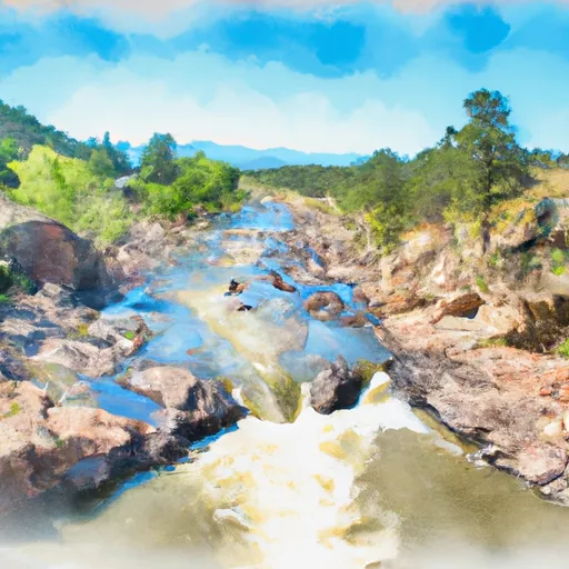
Some of the most prominent rapids include "Haystack," "Surprise," and "The Notch," which require precise maneuvering and technical skill. Additionally, there are several steep drops and narrow chutes that pose a significant challenge to even experienced paddlers.
It is important to note that the Whitewater River Run is located on private property, and access requires permission from the landowners. Additionally, there are specific regulations in place to protect the river's ecosystem, such as a ban on camping and fires along the banks. Paddlers should also take precautions to prevent the spread of invasive species and practice Leave No Trace principles.
Multiple sources confirm the accuracy of this information, including American Whitewater and Colorado Parks and Wildlife. Paddlers should exercise caution and be prepared for the challenges of this exciting river run.
Plan your run down to the hour
Same weather feed Snoflo's iOS app uses -- updated continuously from NOAA / yr.no. Watch the precipitation column on the meteogram; rain ahead of a run typically lifts flows 12-48 hours later depending on the basin.
Next 5 days, hour by hour
Temperature line with weather symbols on top, snow + rain accumulation as columns, humidity as a dotted line.
5-day forecast table
Every 3 hours, broken out across temperature, snow, rain, humidity, and wind. Each cell is colour-coded relative to the column min/max.
| Time | Condition | Temp (°F) | Snow (in) | Rain (in) | Humidity (%) | Wind (mps) | Wind dir |
|---|---|---|---|---|---|---|---|
| Loading detailed forecast… | |||||||
15-day temperature & precipitation
Daily temperatures, snow, and rain projected over the next two weeks -- the upstream story that drives next week's flows.
Regional streamflow levels
USGS streamgauges around Cliffdale To Confluence With South Platte -- useful for spotting upstream pulses and gauging which tributary is contributing what.
| Streamgauge | Discharge | View |
|---|---|---|
| South Platte River At South Platte | 542 cfs | → |
| South Platte River At Waterton | 41 cfs | → |
| Plum Creek Near Sedalia | 8 cfs | → |
| Plum Creek At Titan Rd Nr Louviers | · | → |
| So. Platte R. Blw Brush Cr. Nr Trumbull Co | 197 cfs | → |
| East Plum Cr Blw Haskins Gulch Nr Castle Rock | 1 cfs | → |
Plan a longer trip
The closest boat launches, other paddle runs, and campgrounds so a day on the water can grow into a full weekend.
Boat launches
- Chatfield State Park
- Chatfield Lake North Boat Ramp
- C-470 Trail Lakewood
- West Quincy Avenue Denver
- Fisherman's Trail Lakewood
- Fairway Drive Evergreen
Other river runs
- Wigman Club To Strontia Reservoir
- Foxton
- Estabrook To Cliffdale
- Cheeseman Dam To Wigman Club
- Bailey Canyon
Campgrounds
Fishing spots
- Strontia Springs Reservoir
- Strortia Springs Reservoir
- South Platte River
- Platte Canyon Ditch
- Pine Valley Ranch Pond
- Chatfield Reservoir
Whitewater safety
- Check the flow before you run
- Use the linked-gauge card and Regional Flow panel above. Class ratings change with flow -- a Class III at low water can become Class IV+ at high water.
- Know your skill ceiling
- Pick runs comfortably below your ceiling. Cold-water and big-water runs raise the consequences of any mistake.
- Wear the right gear
- Helmet, PFD, drysuit / wetsuit when water is below 60°F. Throw bag, knife, and whistle on your person, not in the boat.
- Scout, set safety, and run with a team
- Scout new rapids on foot, set safety with throw bags above the consequence pool, and run with at least one other competent paddler.
- Respect the river
- Strainers, undercuts, low-head dams, and wood can kill at any class rating. When in doubt, portage.
Set push alerts in the Snoflo app
Save Cliffdale To Confluence With South Platte as a favorite, set a discharge threshold (e.g. "alert me when flow hits 600 cfs"), and the iOS app pushes the moment the linked gauge crosses.
About Cliffdale To Confluence With South Platte
What's the optimal flow for Cliffdale To Confluence With South Platte?
The optimal flow depends on the section and the craft. Check the Run Details panel for the linked gauge and current status.
How fresh is the cfs reading on this page?
The linked USGS streamgauge reports continuously (every 15 minutes); Snoflo refreshes throughout the day. Hover the streamflow sparkline to read individual datapoints.
What's the whitewater class?
See the Run Details panel for the class rating Snoflo tracks for this run. Class ratings change with flow -- a Class III at low water can become Class IV in high water.
Where do I put in / take out?
Tap Directions in the hero above to open driving directions to the put-in. For shuttle planning, check the Nearby Boat Launches panel and the river run operator's site.
Can I get alerts when flows hit the optimal range?
Yes -- alerts are managed in the Snoflo iOS app. Favorite this run, set a discharge threshold, and you'll get a push the moment the gauge crosses.
Other runs near here
Snoflo-tracked paddle runs within driving distance of Cliffdale To Confluence With South Platte.