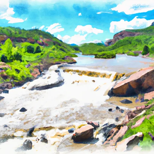
Beaver Lake To Sweet Jessup Headgate River Run
Community Reviews
Been here? Share the conditions.
Reviews, ratings & photos are added in the free Snoflo iOS app — rate a spot, tag the conditions, and your visit is verified by location. Add or manage your reviews from the app.
Beaver Lake To Sweet Jessup Headgate
Some of the specific rapids and obstacles on this section of the river include "Boulder Drop," a Class V rapid with a large boulder in the middle of the river that requires precise maneuvering to avoid. "The Notch" is another notable rapid, with a steep drop and tight turns that require skilled navigation.
There are specific regulations in place for this area, including the requirement for all boaters to wear a personal flotation device (PFD) and carry a whistle and throw rope. Additionally, there are rules against littering and camping along the riverbanks.
Overall, the Beaver Lake to Sweet Jessup Headgate section of the Whitewater River offers challenging rapids and beautiful scenery for experienced kayakers and rafters, but it is important to follow all regulations and safety guidelines to ensure a safe and enjoyable trip. Sources include American Whitewater and Colorado Parks and Wildlife.
Plan your run down to the hour
Same weather feed Snoflo's iOS app uses -- updated continuously from NOAA / yr.no. Watch the precipitation column on the meteogram; rain ahead of a run typically lifts flows 12-48 hours later depending on the basin.
Next 5 days, hour by hour
Temperature line with weather symbols on top, snow + rain accumulation as columns, humidity as a dotted line.
5-day forecast table
Every 3 hours, broken out across temperature, snow, rain, humidity, and wind. Each cell is colour-coded relative to the column min/max.
| Time | Condition | Temp (°F) | Snow (in) | Rain (in) | Humidity (%) | Wind (mps) | Wind dir |
|---|---|---|---|---|---|---|---|
| Loading detailed forecast… | |||||||
15-day temperature & precipitation
Daily temperatures, snow, and rain projected over the next two weeks -- the upstream story that drives next week's flows.
Regional streamflow levels
USGS streamgauges around Beaver Lake To Sweet Jessup Headgate -- useful for spotting upstream pulses and gauging which tributary is contributing what.
| Streamgauge | Discharge | View |
|---|---|---|
| Crystal River Ab Avalanche C | 99 cfs | → |
| Roaring Fork River Near Emma | 295 cfs | → |
| West Divide Creek Near Raven | 0 cfs | → |
| Roaring Fork River At Glenwood Springs | 449 cfs | → |
| Colorado River Below Glenwood Springs | 1,820 cfs | → |
| Fryingpan River Near Ruedi | 196 cfs | → |
Plan a longer trip
The closest boat launches, other paddle runs, and campgrounds so a day on the water can grow into a full weekend.
Boat launches
Other river runs
- Avalanche Down
- Catherine Store Section
- Carbondale To Westbank (Pink To Black)
- Bogan Canyon
- South Fork--Headwaters To Beaver Lake
Campgrounds
- Avalanche
- Avalanche Campground
- Redstone
- Thompson Creek Camp
- Redstone Campground
- Upper Prince Creek Campground
Fishing spots
- Christine Lake
- Fryingpan River
- Beaver Lake Swa (Marble)
- Emerald Lake (Crested Butte)
- Paonia Reservoir
- Ruedi Reservoir
Points of interest
Whitewater safety
- Check the flow before you run
- Use the linked-gauge card and Regional Flow panel above. Class ratings change with flow -- a Class III at low water can become Class IV+ at high water.
- Know your skill ceiling
- Pick runs comfortably below your ceiling. Cold-water and big-water runs raise the consequences of any mistake.
- Wear the right gear
- Helmet, PFD, drysuit / wetsuit when water is below 60°F. Throw bag, knife, and whistle on your person, not in the boat.
- Scout, set safety, and run with a team
- Scout new rapids on foot, set safety with throw bags above the consequence pool, and run with at least one other competent paddler.
- Respect the river
- Strainers, undercuts, low-head dams, and wood can kill at any class rating. When in doubt, portage.
Set push alerts in the Snoflo app
Save Beaver Lake To Sweet Jessup Headgate as a favorite, set a discharge threshold (e.g. "alert me when flow hits 600 cfs"), and the iOS app pushes the moment the linked gauge crosses.
About Beaver Lake To Sweet Jessup Headgate
What's the optimal flow for Beaver Lake To Sweet Jessup Headgate?
The optimal flow depends on the section and the craft. Check the Run Details panel for the linked gauge and current status.
How fresh is the cfs reading on this page?
The linked USGS streamgauge reports continuously (every 15 minutes); Snoflo refreshes throughout the day. Hover the streamflow sparkline to read individual datapoints.
What's the whitewater class?
See the Run Details panel for the class rating Snoflo tracks for this run. Class ratings change with flow -- a Class III at low water can become Class IV in high water.
Where do I put in / take out?
Tap Directions in the hero above to open driving directions to the put-in. For shuttle planning, check the Nearby Boat Launches panel and the river run operator's site.
Can I get alerts when flows hit the optimal range?
Yes -- alerts are managed in the Snoflo iOS app. Favorite this run, set a discharge threshold, and you'll get a push the moment the gauge crosses.
Other runs near here
Snoflo-tracked paddle runs within driving distance of Beaver Lake To Sweet Jessup Headgate.