Fourmile Creek River Run
Community Reviews
Been here? Share the conditions.
Reviews, ratings & photos are added in the free Snoflo iOS app — rate a spot, tag the conditions, and your visit is verified by location. Add or manage your reviews from the app.
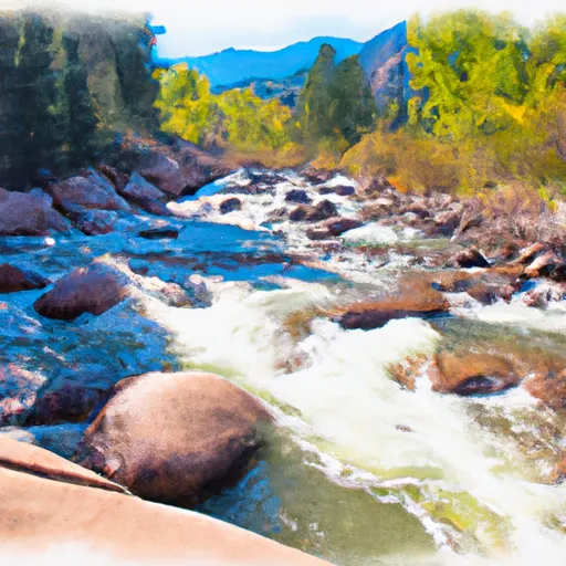
Fourmile Creek
This creek is classified as Class III-IV, with sections of Class V rapids during high water, making it suitable for intermediate and advanced level boaters. The segment mileage for Fourmile Creek is approximately 7 miles, starting at Highway 285 and ending at the Arkansas River. The start of the run provides a few calm stretches, which are followed by challenging rapids such as the "Boneyard" and "Pinball."
One of the most significant obstacles on this creek is a series of low bridges, which require careful navigation. Additionally, the creek runs through private property, so boaters are required to stay on the water and avoid trespassing. The Arkansas Headwaters Recreation Area manages this section of the creek and enforces regulations such as wearing a PFD, respecting private property, and avoiding littering.
Overall, Fourmile Creek offers an exciting river run for experienced whitewater enthusiasts, with a range of challenging rapids and specific regulations to ensure the safety and preservation of the area.
Plan your run down to the hour
Same weather feed Snoflo's iOS app uses -- updated continuously from NOAA / yr.no. Watch the precipitation column on the meteogram; rain ahead of a run typically lifts flows 12-48 hours later depending on the basin.
Next 5 days, hour by hour
Temperature line with weather symbols on top, snow + rain accumulation as columns, humidity as a dotted line.
5-day forecast table
Every 3 hours, broken out across temperature, snow, rain, humidity, and wind. Each cell is colour-coded relative to the column min/max.
| Time | Condition | Temp (°F) | Snow (in) | Rain (in) | Humidity (%) | Wind (mps) | Wind dir |
|---|---|---|---|---|---|---|---|
| Loading detailed forecast… | |||||||
15-day temperature & precipitation
Daily temperatures, snow, and rain projected over the next two weeks -- the upstream story that drives next week's flows.
Regional streamflow levels
USGS streamgauges around Fourmile Creek -- useful for spotting upstream pulses and gauging which tributary is contributing what.
| Streamgauge | Discharge | View |
|---|---|---|
| Fourmile Creek Below Cripple Creek Near Victor | 4 cfs | → |
| South Platte River Near Lake George | 114 cfs | → |
| Beaver Cr Abv Upper Beaver Cemetery Nr Penrose | 4 cfs | → |
| Arkansas River At Parkdale | 217 cfs | → |
| Fountain Creek At Cascade | 68 cfs | → |
| Arkansas River At Canon City | 154 cfs | → |
Plan a longer trip
The closest boat launches, other paddle runs, and campgrounds so a day on the water can grow into a full weekend.
Boat launches
- Skagway Road Teller County
- Forest Road 96.I Park County
- Thirtynine Mile Road Park County
- Arkansas Headwaters Recreation Area
- Ahra - Parkdale Rec Site
Other river runs
Campgrounds
- The Bank Campground Campsite A-13
- The Bank Campground Campsite A-12
- The Bank Campground Campsite A-10
- The Bank Campground Accessible Campsite A-11
- The Bank Campground Campsite A-8
- The Bank Campground Campsite A-9
Fishing spots
- Skaguay Reservoir
- Mason Reservoir
- Mcreynolds Reservoir
- Rosemont Reservoir
- North Catamount Reservoir
- South Catamount Reservoir
Whitewater safety
- Check the flow before you run
- Use the linked-gauge card and Regional Flow panel above. Class ratings change with flow -- a Class III at low water can become Class IV+ at high water.
- Know your skill ceiling
- Pick runs comfortably below your ceiling. Cold-water and big-water runs raise the consequences of any mistake.
- Wear the right gear
- Helmet, PFD, drysuit / wetsuit when water is below 60°F. Throw bag, knife, and whistle on your person, not in the boat.
- Scout, set safety, and run with a team
- Scout new rapids on foot, set safety with throw bags above the consequence pool, and run with at least one other competent paddler.
- Respect the river
- Strainers, undercuts, low-head dams, and wood can kill at any class rating. When in doubt, portage.
Set push alerts in the Snoflo app
Save Fourmile Creek as a favorite, set a discharge threshold (e.g. "alert me when flow hits 600 cfs"), and the iOS app pushes the moment the linked gauge crosses.
About Fourmile Creek
What's the optimal flow for Fourmile Creek?
The optimal flow depends on the section and the craft. Check the Run Details panel for the linked gauge and current status.
How fresh is the cfs reading on this page?
The linked USGS streamgauge reports continuously (every 15 minutes); Snoflo refreshes throughout the day. Hover the streamflow sparkline to read individual datapoints.
What's the whitewater class?
See the Run Details panel for the class rating Snoflo tracks for this run. Class ratings change with flow -- a Class III at low water can become Class IV in high water.
Where do I put in / take out?
Tap Directions in the hero above to open driving directions to the put-in. For shuttle planning, check the Nearby Boat Launches panel and the river run operator's site.
Can I get alerts when flows hit the optimal range?
Yes -- alerts are managed in the Snoflo iOS app. Favorite this run, set a discharge threshold, and you'll get a push the moment the gauge crosses.
Other runs near here
Snoflo-tracked paddle runs within driving distance of Fourmile Creek.