Sierra Vandera--Headwaters To Confluence With Los Pinos river run
Sierra Vandera--Headwaters To Confluence With Los Pinos
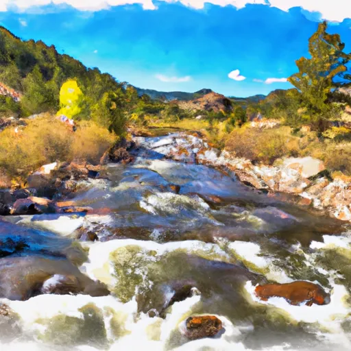
The first two miles of the river are considered Class II, with some technical terrain and obstacles such as rocks and small drops. The next three miles increase to a Class III rating, with bigger drops and faster currents. The final five miles are a mix of Class II and III rapids with the occasional Class IV.
One of the most popular rapids on this run is known as "Sawmill," which is a Class III rapid with a steep drop in the middle. There are also other notable rapids such as "Jaws," "Boulder Garden," and "Pinball."
The Whitewater River Run Sierra Vandera is regulated by the Bureau of Land Management, which requires all river users to wear personal flotation devices and helmets. The use of alcohol and drugs is strictly prohibited while on the river. Additionally, all river users must have proper permits and follow Leave No Trace principles to protect the environment.
Overall, the Whitewater River Run Sierra Vandera offers a thrilling and challenging experience for intermediate and advanced paddlers. It is important to check the streamflow levels and regulations before planning a trip to ensure a safe and enjoyable experience.
Plan your run down to the hour
Same weather feed Snoflo's iOS app uses -- updated continuously from NOAA / yr.no. Watch the precipitation column on the meteogram; rain ahead of a run typically lifts flows 12-48 hours later depending on the basin.
Next 5 days, hour by hour
Temperature line with weather symbols on top, snow + rain accumulation as columns, humidity as a dotted line.
5-day forecast table
Every 3 hours, broken out across temperature, snow, rain, humidity, and wind. Each cell is colour-coded relative to the column min/max.
| Time | Condition | Temp (°F) | Snow (in) | Rain (in) | Humidity (%) | Wind (mps) | Wind dir |
|---|---|---|---|---|---|---|---|
| Loading detailed forecast… | |||||||
15-day temperature & precipitation
Daily temperatures, snow, and rain projected over the next two weeks -- the upstream story that drives next week's flows.
Regional streamflow levels
USGS streamgauges around Sierra Vandera--Headwaters To Confluence With Los Pinos -- useful for spotting upstream pulses and gauging which tributary is contributing what.
| Streamgauge | Discharge | View |
|---|---|---|
| Vallecito Creek Near Bayfield | 451 cfs | → |
| Rio Grande At Thirtymile Bridge | 949 cfs | → |
| Animas River At Howardsville | 262 cfs | → |
| Animas River Below Silverton | 646 cfs | → |
| Animas River Above Tacoma | 1,290 cfs | → |
| Animas River At Silverton | 281 cfs | → |
Plan a longer trip
The closest boat launches, other paddle runs, and campgrounds so a day on the water can grow into a full weekend.
Other river runs
- Flint Creek--Headwaters To Confluence With Los Pinos
- Rincon La Osa--Headwaters To Confluence With Los Pinos
- Lake Creek--Headwaters To Confluence With Los Pinos
- Snowslide Canyon Creek--Headwaters To Confluence With Los Pinos
- Rincon La Vaca--Headwaters To Confluence With Los Pinos
Whitewater safety
- Check the flow before you run
- Use the linked-gauge card and Regional Flow panel above. Class ratings change with flow -- a Class III at low water can become Class IV+ at high water.
- Know your skill ceiling
- Pick runs comfortably below your ceiling. Cold-water and big-water runs raise the consequences of any mistake.
- Wear the right gear
- Helmet, PFD, drysuit / wetsuit when water is below 60°F. Throw bag, knife, and whistle on your person, not in the boat.
- Scout, set safety, and run with a team
- Scout new rapids on foot, set safety with throw bags above the consequence pool, and run with at least one other competent paddler.
- Respect the river
- Strainers, undercuts, low-head dams, and wood can kill at any class rating. When in doubt, portage.
Set push alerts in the Snoflo app
Save Sierra Vandera--Headwaters To Confluence With Los Pinos as a favorite, set a discharge threshold (e.g. "alert me when flow hits 600 cfs"), and the iOS app pushes the moment the linked gauge crosses.
About Sierra Vandera--Headwaters To Confluence With Los Pinos
What's the optimal flow for Sierra Vandera--Headwaters To Confluence With Los Pinos?
The optimal flow depends on the section and the craft. Check the Run Details panel for the linked gauge and current status.
How fresh is the cfs reading on this page?
The linked USGS streamgauge reports continuously (every 15 minutes); Snoflo refreshes throughout the day. Hover the streamflow sparkline to read individual datapoints.
What's the whitewater class?
See the Run Details panel for the class rating Snoflo tracks for this run. Class ratings change with flow -- a Class III at low water can become Class IV in high water.
Where do I put in / take out?
Tap Directions in the hero above to open driving directions to the put-in. For shuttle planning, check the Nearby Boat Launches panel and the river run operator's site.
Can I get alerts when flows hit the optimal range?
Yes -- alerts are managed in the Snoflo iOS app. Favorite this run, set a discharge threshold, and you'll get a push the moment the gauge crosses.
Other runs near here
Snoflo-tracked paddle runs within driving distance of Sierra Vandera--Headwaters To Confluence With Los Pinos.