Confluence With Bell Creek To Boiling Springs Cabin River Run
Community Reviews
Been here? Share the conditions.
Reviews, ratings & photos are added in the free Snoflo iOS app — rate a spot, tag the conditions, and your visit is verified by location. Add or manage your reviews from the app.
Confluence With Bell Creek To Boiling Springs Cabin
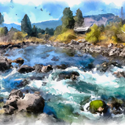
The Whitewater River Run from Confluence with Bell Creek to Boiling Springs Cabin in Idaho is a popular destination for whitewater enthusiasts. The ideal streamflow range for this section of the river is between 1,000 and 3,000 cfs. At lower flows, the rapids can be more technical and rocky, while at higher flows, the rapids become more powerful and fast-paced.
This section of the river is rated as Class IV, making it suitable for experienced rafters and kayakers. The segment mileage is approximately 10 miles, with rapids such as Devil's Tooth, The Ladder, and Fang. Devil's Tooth is a particularly challenging rapid with a large boulder in the center of the river that requires precise maneuvering to navigate safely.
There are specific regulations for this area, including the requirement of a permit to run the river and a limit on the number of permits issued per day. Additionally, visitors are required to pack out all trash and respect the natural environment.
In conclusion, the Whitewater River Run from Confluence with Bell Creek to Boiling Springs Cabin is a thrilling and challenging section of the river with a Class IV rating. The ideal streamflow range is between 1,000 and 3,000 cfs, and there are specific regulations in place to protect the environment and ensure visitor safety.
Plan your run down to the hour
Same weather feed Snoflo's iOS app uses -- updated continuously from NOAA / yr.no. Watch the precipitation column on the meteogram; rain ahead of a run typically lifts flows 12-48 hours later depending on the basin.
Next 5 days, hour by hour
Temperature line with weather symbols on top, snow + rain accumulation as columns, humidity as a dotted line.
5-day forecast table
Every 3 hours, broken out across temperature, snow, rain, humidity, and wind. Each cell is colour-coded relative to the column min/max.
| Time | Condition | Temp (°F) | Snow (in) | Rain (in) | Humidity (%) | Wind (mps) | Wind dir |
|---|---|---|---|---|---|---|---|
| Loading detailed forecast… | |||||||
15-day temperature & precipitation
Daily temperatures, snow, and rain projected over the next two weeks -- the upstream story that drives next week's flows.
Regional streamflow levels
USGS streamgauges around Confluence With Bell Creek To Boiling Springs Cabin -- useful for spotting upstream pulses and gauging which tributary is contributing what.
| Streamgauge | Discharge | View |
|---|---|---|
| Middle Fork Payette River Nr Crouch Id | 128 cfs | → |
| Nf Payette River Nr Banks Id | 1,410 cfs | → |
| Deadwood River Bl Deadwood Res Nr Lowman Id | 848 cfs | → |
| Sf Payette River At Lowman Id | 500 cfs | → |
| Payette River Nr Horseshoe Bend Id | 2,980 cfs | → |
| Payette River Nr Emmett Id | 1,560 cfs | → |
Plan a longer trip
The closest boat launches, other paddle runs, and campgrounds so a day on the water can grow into a full weekend.
Boat launches
- Cougar Mountain
- Confluence
- Deer Creek
- Cabarton Road Valley County
- Banks River Access
- Sage Hen Creek Boat Ramp
Other river runs
- Boiling Springs Cabin To Confluence With Fool Creek
- South Fork Payette
- Long Gulch To Boise Nf Boundary
- Deadwood Reservoir To Confluence With Warm Springs Creek
- Warm Springs Creek To Confluence With Pine Creek
Campgrounds
- Hardscrabble Campground
- Hardscrabble
- Tie Creek
- Tie Creek Campground
- Rattlesnake Campground And Group Sites - Reserve
- Rattlesnake
Fishing spots
Whitewater safety
- Check the flow before you run
- Use the linked-gauge card and Regional Flow panel above. Class ratings change with flow -- a Class III at low water can become Class IV+ at high water.
- Know your skill ceiling
- Pick runs comfortably below your ceiling. Cold-water and big-water runs raise the consequences of any mistake.
- Wear the right gear
- Helmet, PFD, drysuit / wetsuit when water is below 60°F. Throw bag, knife, and whistle on your person, not in the boat.
- Scout, set safety, and run with a team
- Scout new rapids on foot, set safety with throw bags above the consequence pool, and run with at least one other competent paddler.
- Respect the river
- Strainers, undercuts, low-head dams, and wood can kill at any class rating. When in doubt, portage.
Set push alerts in the Snoflo app
Save Confluence With Bell Creek To Boiling Springs Cabin as a favorite, set a discharge threshold (e.g. "alert me when flow hits 600 cfs"), and the iOS app pushes the moment the linked gauge crosses.
About Confluence With Bell Creek To Boiling Springs Cabin
What's the optimal flow for Confluence With Bell Creek To Boiling Springs Cabin?
The optimal flow depends on the section and the craft. Check the Run Details panel for the linked gauge and current status.
How fresh is the cfs reading on this page?
The linked USGS streamgauge reports continuously (every 15 minutes); Snoflo refreshes throughout the day. Hover the streamflow sparkline to read individual datapoints.
What's the whitewater class?
See the Run Details panel for the class rating Snoflo tracks for this run. Class ratings change with flow -- a Class III at low water can become Class IV in high water.
Where do I put in / take out?
Tap Directions in the hero above to open driving directions to the put-in. For shuttle planning, check the Nearby Boat Launches panel and the river run operator's site.
Can I get alerts when flows hit the optimal range?
Yes -- alerts are managed in the Snoflo iOS app. Favorite this run, set a discharge threshold, and you'll get a push the moment the gauge crosses.
Other runs near here
Snoflo-tracked paddle runs within driving distance of Confluence With Bell Creek To Boiling Springs Cabin.