Headwaters To Confluence With Elk Creek River Run
Community Reviews
Been here? Share the conditions.
Reviews, ratings & photos are added in the free Snoflo iOS app — rate a spot, tag the conditions, and your visit is verified by location. Add or manage your reviews from the app.
Headwaters To Confluence With Elk Creek
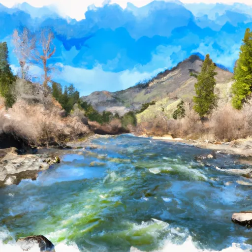
The class rating for this run ranges from II to IV, with the more challenging rapids located closer to the confluence with Elk Creek. The total segment mileage for this run is approximately 13 miles.
Some of the notable rapids and obstacles on this section of the river include the Staircase Rapid, which is a Class III rapid with a steep drop and large waves, and the Big Kahuna Rapid, which is a Class IV rapid with a large hydraulic feature that requires precise navigation.
It is important to note that the Whitewater River Run falls under the jurisdiction of the Bureau of Land Management and has specific regulations that visitors must follow. These regulations include requirements for personal flotation devices, restrictions on alcohol consumption, and guidelines for camping and fires. Visitors should also be aware of potential hazards on the river, such as downed trees and submerged rocks, and should always exercise caution while navigating the rapids.
Plan your run down to the hour
Same weather feed Snoflo's iOS app uses -- updated continuously from NOAA / yr.no. Watch the precipitation column on the meteogram; rain ahead of a run typically lifts flows 12-48 hours later depending on the basin.
Next 5 days, hour by hour
Temperature line with weather symbols on top, snow + rain accumulation as columns, humidity as a dotted line.
5-day forecast table
Every 3 hours, broken out across temperature, snow, rain, humidity, and wind. Each cell is colour-coded relative to the column min/max.
| Time | Condition | Temp (°F) | Snow (in) | Rain (in) | Humidity (%) | Wind (mps) | Wind dir |
|---|---|---|---|---|---|---|---|
| Loading detailed forecast… | |||||||
15-day temperature & precipitation
Daily temperatures, snow, and rain projected over the next two weeks -- the upstream story that drives next week's flows.
Regional streamflow levels
USGS streamgauges around Headwaters To Confluence With Elk Creek -- useful for spotting upstream pulses and gauging which tributary is contributing what.
| Streamgauge | Discharge | View |
|---|---|---|
| Deadwood River Bl Deadwood Res Nr Lowman Id | 848 cfs | → |
| Sf Payette River At Lowman Id | 500 cfs | → |
| Mf Salmon River At Mf Lodge Nr Yellow Pine Id | 759 cfs | → |
| Valley Creek At Stanley Id | 124 cfs | → |
| Ef Of Sf Salmon River At Stibnite Id | 46 cfs | → |
| Efsf Salmon R Abv Sugar Crk Nr Stibnite | 82 cfs | → |
Plan a longer trip
The closest boat launches, other paddle runs, and campgrounds so a day on the water can grow into a full weekend.
Other river runs
- Fcronr Wilderness Boundary To Confluence With North Fork Elk Creek
- Confluence Bear Valley Creek To Fcronr Wilderness Boundary
- Elk Creek To Fir Creek Campground
- Boundary Creek To Cache Bar
Campgrounds
- Elk Creek Guard Station - Rental Cabins
- Bear Valley Campground
- Bear Valley
- Deer Flat
- Deer Flat Campground
- Fir Creek Campground
Fishing spots
Whitewater safety
- Check the flow before you run
- Use the linked-gauge card and Regional Flow panel above. Class ratings change with flow -- a Class III at low water can become Class IV+ at high water.
- Know your skill ceiling
- Pick runs comfortably below your ceiling. Cold-water and big-water runs raise the consequences of any mistake.
- Wear the right gear
- Helmet, PFD, drysuit / wetsuit when water is below 60°F. Throw bag, knife, and whistle on your person, not in the boat.
- Scout, set safety, and run with a team
- Scout new rapids on foot, set safety with throw bags above the consequence pool, and run with at least one other competent paddler.
- Respect the river
- Strainers, undercuts, low-head dams, and wood can kill at any class rating. When in doubt, portage.
Set push alerts in the Snoflo app
Save Headwaters To Confluence With Elk Creek as a favorite, set a discharge threshold (e.g. "alert me when flow hits 600 cfs"), and the iOS app pushes the moment the linked gauge crosses.
About Headwaters To Confluence With Elk Creek
What's the optimal flow for Headwaters To Confluence With Elk Creek?
The optimal flow depends on the section and the craft. Check the Run Details panel for the linked gauge and current status.
How fresh is the cfs reading on this page?
The linked USGS streamgauge reports continuously (every 15 minutes); Snoflo refreshes throughout the day. Hover the streamflow sparkline to read individual datapoints.
What's the whitewater class?
See the Run Details panel for the class rating Snoflo tracks for this run. Class ratings change with flow -- a Class III at low water can become Class IV in high water.
Where do I put in / take out?
Tap Directions in the hero above to open driving directions to the put-in. For shuttle planning, check the Nearby Boat Launches panel and the river run operator's site.
Can I get alerts when flows hit the optimal range?
Yes -- alerts are managed in the Snoflo iOS app. Favorite this run, set a discharge threshold, and you'll get a push the moment the gauge crosses.
Other runs near here
Snoflo-tracked paddle runs within driving distance of Headwaters To Confluence With Elk Creek.