Trail Creek To Sawtooth Nf Boundary River Run
Community Reviews
Been here? Share the conditions.
Reviews, ratings & photos are added in the free Snoflo iOS app — rate a spot, tag the conditions, and your visit is verified by location. Add or manage your reviews from the app.
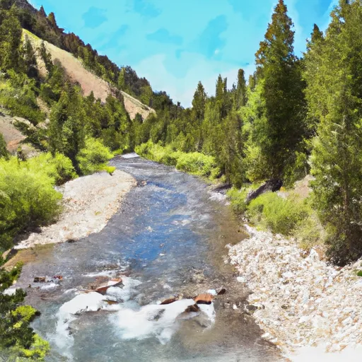
Trail Creek To Sawtooth Nf Boundary
The segment mileage for this section is approximately 8 miles, with stunning views of the surrounding wilderness and the Sawtooth Mountains. It is important to note that this section of the river is only navigable during certain times of the year, typically from late May to early July.
There are specific regulations to the area, including a permit requirement for commercial use and a limit on the number of users per day. Additionally, all users must wear a personal flotation device and be prepared for cold water temperatures.
Plan your run down to the hour
Same weather feed Snoflo's iOS app uses -- updated continuously from NOAA / yr.no. Watch the precipitation column on the meteogram; rain ahead of a run typically lifts flows 12-48 hours later depending on the basin.
Next 5 days, hour by hour
Temperature line with weather symbols on top, snow + rain accumulation as columns, humidity as a dotted line.
5-day forecast table
Every 3 hours, broken out across temperature, snow, rain, humidity, and wind. Each cell is colour-coded relative to the column min/max.
| Time | Condition | Temp (°F) | Snow (in) | Rain (in) | Humidity (%) | Wind (mps) | Wind dir |
|---|---|---|---|---|---|---|---|
| Loading detailed forecast… | |||||||
15-day temperature & precipitation
Daily temperatures, snow, and rain projected over the next two weeks -- the upstream story that drives next week's flows.
Regional streamflow levels
USGS streamgauges around Trail Creek To Sawtooth Nf Boundary -- useful for spotting upstream pulses and gauging which tributary is contributing what.
| Streamgauge | Discharge | View |
|---|---|---|
| Valley Creek At Stanley Id | 124 cfs | → |
| Sf Payette River At Lowman Id | 500 cfs | → |
| Salmon River Bl Yankee Fork Nr Clayton Id | 590 cfs | → |
| Yankee Fork Salmon River Nr Clayton Id | 94 cfs | → |
| Deadwood River Bl Deadwood Res Nr Lowman Id | 848 cfs | → |
| Thompson Creek Nr Clayton Id | 5 cfs | → |
Plan a longer trip
The closest boat launches, other paddle runs, and campgrounds so a day on the water can grow into a full weekend.
Other river runs
- Headwaters To Confluence With Trail Creek
- Headwaters To Confluence With South Fork Payette River
- Sawtooth Nra To Confluence With Wolf Creek
- Headwaters To Lady Face Falls
Campgrounds
- Grandjean Campground
- Grandjean
- Sawtooth National Forest - Grandjean Campground
- Bonneville Campground - Reserve
- Bonneville Campground
- Bonneville
Fishing spots
- Stanley Lake
- Lowman Nature Ponds
- Redfish Lake
- Yellowbelly Lake
- Alturas Lake And Pettit Lake Areas
- Perkins Lake
Points of interest
Whitewater safety
- Check the flow before you run
- Use the linked-gauge card and Regional Flow panel above. Class ratings change with flow -- a Class III at low water can become Class IV+ at high water.
- Know your skill ceiling
- Pick runs comfortably below your ceiling. Cold-water and big-water runs raise the consequences of any mistake.
- Wear the right gear
- Helmet, PFD, drysuit / wetsuit when water is below 60°F. Throw bag, knife, and whistle on your person, not in the boat.
- Scout, set safety, and run with a team
- Scout new rapids on foot, set safety with throw bags above the consequence pool, and run with at least one other competent paddler.
- Respect the river
- Strainers, undercuts, low-head dams, and wood can kill at any class rating. When in doubt, portage.
Set push alerts in the Snoflo app
Save Trail Creek To Sawtooth Nf Boundary as a favorite, set a discharge threshold (e.g. "alert me when flow hits 600 cfs"), and the iOS app pushes the moment the linked gauge crosses.
About Trail Creek To Sawtooth Nf Boundary
What's the optimal flow for Trail Creek To Sawtooth Nf Boundary?
The optimal flow depends on the section and the craft. Check the Run Details panel for the linked gauge and current status.
How fresh is the cfs reading on this page?
The linked USGS streamgauge reports continuously (every 15 minutes); Snoflo refreshes throughout the day. Hover the streamflow sparkline to read individual datapoints.
What's the whitewater class?
See the Run Details panel for the class rating Snoflo tracks for this run. Class ratings change with flow -- a Class III at low water can become Class IV in high water.
Where do I put in / take out?
Tap Directions in the hero above to open driving directions to the put-in. For shuttle planning, check the Nearby Boat Launches panel and the river run operator's site.
Can I get alerts when flows hit the optimal range?
Yes -- alerts are managed in the Snoflo iOS app. Favorite this run, set a discharge threshold, and you'll get a push the moment the gauge crosses.
Other runs near here
Snoflo-tracked paddle runs within driving distance of Trail Creek To Sawtooth Nf Boundary.