Ponderosa Campground To Confluence With South Fork Salmon River River Run
Community Reviews
Been here? Share the conditions.
Reviews, ratings & photos are added in the free Snoflo iOS app — rate a spot, tag the conditions, and your visit is verified by location. Add or manage your reviews from the app.
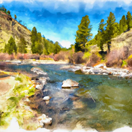
Ponderosa Campground To Confluence With South Fork Salmon River
This segment of the river spans roughly 30 miles, with the most challenging rapids located in the first 10 miles. The rapids are primarily Class II, with a few Class III rapids scattered throughout the run. Some of the more notable rapids include Bullet Hole, Jaws, and The Slide. The rapids are challenging enough to provide excitement but not so difficult that they require expert-level skills.
While the run is open to the public, there are specific regulations to follow. A permit is required to launch a private raft or kayak, and all groups must carry and use a portable toilet to comply with Leave No Trace principles. In addition, campfires are only allowed in designated areas and must be completely extinguished before leaving.
Overall, the Whitewater River Run from Ponderosa Campground to the Confluence with South Fork Salmon River is a fantastic option for intermediate-level paddlers looking for a fun and scenic adventure. With proper preparation and adherence to regulations, visitors are sure to have a memorable experience on this beautiful river.
Plan your run down to the hour
Same weather feed Snoflo's iOS app uses -- updated continuously from NOAA / yr.no. Watch the precipitation column on the meteogram; rain ahead of a run typically lifts flows 12-48 hours later depending on the basin.
Next 5 days, hour by hour
Temperature line with weather symbols on top, snow + rain accumulation as columns, humidity as a dotted line.
5-day forecast table
Every 3 hours, broken out across temperature, snow, rain, humidity, and wind. Each cell is colour-coded relative to the column min/max.
| Time | Condition | Temp (°F) | Snow (in) | Rain (in) | Humidity (%) | Wind (mps) | Wind dir |
|---|---|---|---|---|---|---|---|
| Loading detailed forecast… | |||||||
15-day temperature & precipitation
Daily temperatures, snow, and rain projected over the next two weeks -- the upstream story that drives next week's flows.
Regional streamflow levels
USGS streamgauges around Ponderosa Campground To Confluence With South Fork Salmon River -- useful for spotting upstream pulses and gauging which tributary is contributing what.
| Streamgauge | Discharge | View |
|---|---|---|
| Sf Salmon River Nr Krassel Ranger Station Id | 171 cfs | → |
| Johnson Creek At Yellow Pine Id | 111 cfs | → |
| Lake Fork Payette River Ab Jumbo Cr Nr Mccall Id | 35 cfs | → |
| Sugar Creek Nr Stibnite | 37 cfs | → |
| Efsf Salmon R Abv Sugar Crk Nr Stibnite | 82 cfs | → |
| Nf Payette River At Mccall Id | 57 cfs | → |
Plan a longer trip
The closest boat launches, other paddle runs, and campgrounds so a day on the water can grow into a full weekend.
Boat launches
Other river runs
- Chinook Campground To Ponderosa Campground
- Payette Nf Boundary On Lake Creek (Just West Marshall Lake) To To And Including Chinook Campground
- Confluence With Bear Creek To Confluence With Hanson Creek
- Headwaters (Boise Nf) To Confluence With Smith Creek (Smith Creek Landing Strip) (Payette Nf)
- Junction Fr 447 To Confluence With Johnson Creek
Whitewater safety
- Check the flow before you run
- Use the linked-gauge card and Regional Flow panel above. Class ratings change with flow -- a Class III at low water can become Class IV+ at high water.
- Know your skill ceiling
- Pick runs comfortably below your ceiling. Cold-water and big-water runs raise the consequences of any mistake.
- Wear the right gear
- Helmet, PFD, drysuit / wetsuit when water is below 60°F. Throw bag, knife, and whistle on your person, not in the boat.
- Scout, set safety, and run with a team
- Scout new rapids on foot, set safety with throw bags above the consequence pool, and run with at least one other competent paddler.
- Respect the river
- Strainers, undercuts, low-head dams, and wood can kill at any class rating. When in doubt, portage.
Set push alerts in the Snoflo app
Save Ponderosa Campground To Confluence With South Fork Salmon River as a favorite, set a discharge threshold (e.g. "alert me when flow hits 600 cfs"), and the iOS app pushes the moment the linked gauge crosses.
About Ponderosa Campground To Confluence With South Fork Salmon River
What's the optimal flow for Ponderosa Campground To Confluence With South Fork Salmon River?
The optimal flow depends on the section and the craft. Check the Run Details panel for the linked gauge and current status.
How fresh is the cfs reading on this page?
The linked USGS streamgauge reports continuously (every 15 minutes); Snoflo refreshes throughout the day. Hover the streamflow sparkline to read individual datapoints.
What's the whitewater class?
See the Run Details panel for the class rating Snoflo tracks for this run. Class ratings change with flow -- a Class III at low water can become Class IV in high water.
Where do I put in / take out?
Tap Directions in the hero above to open driving directions to the put-in. For shuttle planning, check the Nearby Boat Launches panel and the river run operator's site.
Can I get alerts when flows hit the optimal range?
Yes -- alerts are managed in the Snoflo iOS app. Favorite this run, set a discharge threshold, and you'll get a push the moment the gauge crosses.
Other runs near here
Snoflo-tracked paddle runs within driving distance of Ponderosa Campground To Confluence With South Fork Salmon River.