Headwaters To Confluence With Corral Creek River Run
Community Reviews
Been here? Share the conditions.
Reviews, ratings & photos are added in the free Snoflo iOS app — rate a spot, tag the conditions, and your visit is verified by location. Add or manage your reviews from the app.
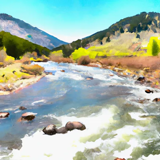
Headwaters To Confluence With Corral Creek
This river run is rated as Class III-IV, which means it contains moderate to difficult rapids and obstacles that require good maneuvering skills. The segment mileage for this run is approximately 20 miles, which can be covered in a day or split into multiple days, depending on the pace of the group.
Some of the specific river rapids and obstacles include The Slot, a narrow and steep drop with a large hole at the bottom, and Hell's Half Mile, a series of challenging and technical rapids. The river also has some calm stretches that allow for some rest and relaxation.
To ensure the safety of all participants, there are specific regulations in place for this area. All individuals must wear a US Coast Guard-approved personal flotation device (PFD) at all times while on the river. Alcoholic beverages are not allowed on the river, and all trash must be packed out.
In conclusion, the Whitewater River Run from Headwaters to Confluence with Corral Creek in Idaho is a thrilling and challenging experience for kayaking and rafting enthusiasts. With the ideal streamflow range, class rating, segment mileage, specific river rapids/obstacles, and specific regulations in place, this river run is a must-visit for anyone looking for an adventure on the water.
Plan your run down to the hour
Same weather feed Snoflo's iOS app uses -- updated continuously from NOAA / yr.no. Watch the precipitation column on the meteogram; rain ahead of a run typically lifts flows 12-48 hours later depending on the basin.
Next 5 days, hour by hour
Temperature line with weather symbols on top, snow + rain accumulation as columns, humidity as a dotted line.
5-day forecast table
Every 3 hours, broken out across temperature, snow, rain, humidity, and wind. Each cell is colour-coded relative to the column min/max.
| Time | Condition | Temp (°F) | Snow (in) | Rain (in) | Humidity (%) | Wind (mps) | Wind dir |
|---|---|---|---|---|---|---|---|
| Loading detailed forecast… | |||||||
15-day temperature & precipitation
Daily temperatures, snow, and rain projected over the next two weeks -- the upstream story that drives next week's flows.
Regional streamflow levels
USGS streamgauges around Headwaters To Confluence With Corral Creek -- useful for spotting upstream pulses and gauging which tributary is contributing what.
| Streamgauge | Discharge | View |
|---|---|---|
| Trail Creek At Ketchum Id | 14 cfs | → |
| Warm Springs Cr At Guyer Hot Spr Nr Ketchum Id | 98 cfs | → |
| Nf Big Wood River Nr Sawtooth Nra Hq Nr Ketchum Id | 42 cfs | → |
| Big Wood River Nr Ketchum Id | 76 cfs | → |
| Big Wood River At Hailey Id Total Flow | 182 cfs | → |
| Nf Big Lost River At Wild Horse Nr Chilly Id | 51 cfs | → |
Plan a longer trip
The closest boat launches, other paddle runs, and campgrounds so a day on the water can grow into a full weekend.
Other river runs
- Headwaters To Sawtooth Nf Boundary
- Headwaters To Confluence With Button Creek
- West Fork Big Wood River To Confluence With Big Wood River
- Headwaters To Point Where Creek Turns Ne, Near Trail Creek Summit
- Headwaters To Confluence With North Fork Big Wood River
Campgrounds
Fishing spots
Whitewater safety
- Check the flow before you run
- Use the linked-gauge card and Regional Flow panel above. Class ratings change with flow -- a Class III at low water can become Class IV+ at high water.
- Know your skill ceiling
- Pick runs comfortably below your ceiling. Cold-water and big-water runs raise the consequences of any mistake.
- Wear the right gear
- Helmet, PFD, drysuit / wetsuit when water is below 60°F. Throw bag, knife, and whistle on your person, not in the boat.
- Scout, set safety, and run with a team
- Scout new rapids on foot, set safety with throw bags above the consequence pool, and run with at least one other competent paddler.
- Respect the river
- Strainers, undercuts, low-head dams, and wood can kill at any class rating. When in doubt, portage.
Set push alerts in the Snoflo app
Save Headwaters To Confluence With Corral Creek as a favorite, set a discharge threshold (e.g. "alert me when flow hits 600 cfs"), and the iOS app pushes the moment the linked gauge crosses.
About Headwaters To Confluence With Corral Creek
What's the optimal flow for Headwaters To Confluence With Corral Creek?
The optimal flow depends on the section and the craft. Check the Run Details panel for the linked gauge and current status.
How fresh is the cfs reading on this page?
The linked USGS streamgauge reports continuously (every 15 minutes); Snoflo refreshes throughout the day. Hover the streamflow sparkline to read individual datapoints.
What's the whitewater class?
See the Run Details panel for the class rating Snoflo tracks for this run. Class ratings change with flow -- a Class III at low water can become Class IV in high water.
Where do I put in / take out?
Tap Directions in the hero above to open driving directions to the put-in. For shuttle planning, check the Nearby Boat Launches panel and the river run operator's site.
Can I get alerts when flows hit the optimal range?
Yes -- alerts are managed in the Snoflo iOS app. Favorite this run, set a discharge threshold, and you'll get a push the moment the gauge crosses.
Other runs near here
Snoflo-tracked paddle runs within driving distance of Headwaters To Confluence With Corral Creek.