Headwaters (Boise Nf) To Confluence With Smith Creek (Smith Creek Landing Strip) (Payette Nf) River Run
Community Reviews
Been here? Share the conditions.
Reviews, ratings & photos are added in the free Snoflo iOS app — rate a spot, tag the conditions, and your visit is verified by location. Add or manage your reviews from the app.
Headwaters (Boise Nf) To Confluence With Smith Creek (Smith Creek Landing Strip) (Payette Nf)
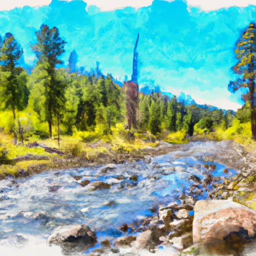
The class rating for this segment of the river is class III-IV, which means it has moderate to difficult rapids with high, irregular waves and narrow passages that often require precise maneuvering. The segment is around 12 miles long and is known for its scenic beauty, with towering granite walls and stunning mountain vistas.
Specific rapids and obstacles along this stretch of river include names such as the "Staircase", a series of steep drops and boulder gardens that require expert navigation, and the "Devil's Slide", a narrow chute with a drop of several feet that requires precise maneuvering. There are also several large boulders and log jams that can create dangerous hazards if not navigated properly.
Specific regulations for the area include the need for a permit to launch a raft or kayak. The permit system is designed to limit the number of people on the river at any given time to ensure safety and preserve the natural environment. Additionally, all boaters are required to wear personal floatation devices and are encouraged to pack out all trash and waste to minimize impact on the surrounding wilderness.
Overall, the Headwaters to Smith Creek segment of the Payette River provides a thrilling and scenic whitewater experience for those with the skills and experience to navigate its challenging rapids.
Plan your run down to the hour
Same weather feed Snoflo's iOS app uses -- updated continuously from NOAA / yr.no. Watch the precipitation column on the meteogram; rain ahead of a run typically lifts flows 12-48 hours later depending on the basin.
Next 5 days, hour by hour
Temperature line with weather symbols on top, snow + rain accumulation as columns, humidity as a dotted line.
5-day forecast table
Every 3 hours, broken out across temperature, snow, rain, humidity, and wind. Each cell is colour-coded relative to the column min/max.
| Time | Condition | Temp (°F) | Snow (in) | Rain (in) | Humidity (%) | Wind (mps) | Wind dir |
|---|---|---|---|---|---|---|---|
| Loading detailed forecast… | |||||||
15-day temperature & precipitation
Daily temperatures, snow, and rain projected over the next two weeks -- the upstream story that drives next week's flows.
Regional streamflow levels
USGS streamgauges around Headwaters (Boise Nf) To Confluence With Smith Creek (Smith Creek Landing Strip) (Payette Nf) -- useful for spotting upstream pulses and gauging which tributary is contributing what.
| Streamgauge | Discharge | View |
|---|---|---|
| Johnson Creek At Yellow Pine Id | 102 cfs | → |
| Sf Salmon River Nr Krassel Ranger Station Id | 154 cfs | → |
| Sugar Creek Nr Stibnite | 37 cfs | → |
| Efsf Salmon R Abv Sugar Crk Nr Stibnite | 82 cfs | → |
| Ef Of Sf Salmon River At Stibnite Id | 46 cfs | → |
| Lake Fork Payette River Ab Jumbo Cr Nr Mccall Id | 27 cfs | → |
Plan a longer trip
The closest boat launches, other paddle runs, and campgrounds so a day on the water can grow into a full weekend.
Other river runs
- Smith Creek To Confluence With Main Salmon
- Payette Nf Boundary On Lake Creek (Just West Marshall Lake) To To And Including Chinook Campground
- Chinook Campground To Ponderosa Campground
- Ponderosa Campground To Confluence With South Fork Salmon River
- Crooked Creek, Sec. 10, T25n, R7e To Gospel-Hump Wilderness Boundary
Whitewater safety
- Check the flow before you run
- Use the linked-gauge card and Regional Flow panel above. Class ratings change with flow -- a Class III at low water can become Class IV+ at high water.
- Know your skill ceiling
- Pick runs comfortably below your ceiling. Cold-water and big-water runs raise the consequences of any mistake.
- Wear the right gear
- Helmet, PFD, drysuit / wetsuit when water is below 60°F. Throw bag, knife, and whistle on your person, not in the boat.
- Scout, set safety, and run with a team
- Scout new rapids on foot, set safety with throw bags above the consequence pool, and run with at least one other competent paddler.
- Respect the river
- Strainers, undercuts, low-head dams, and wood can kill at any class rating. When in doubt, portage.
Set push alerts in the Snoflo app
Save Headwaters (Boise Nf) To Confluence With Smith Creek (Smith Creek Landing Strip) (Payette Nf) as a favorite, set a discharge threshold (e.g. "alert me when flow hits 600 cfs"), and the iOS app pushes the moment the linked gauge crosses.
About Headwaters (Boise Nf) To Confluence With Smith Creek (Smith Creek Landing Strip) (Payette Nf)
What's the optimal flow for Headwaters (Boise Nf) To Confluence With Smith Creek (Smith Creek Landing Strip) (Payette Nf)?
The optimal flow depends on the section and the craft. Check the Run Details panel for the linked gauge and current status.
How fresh is the cfs reading on this page?
The linked USGS streamgauge reports continuously (every 15 minutes); Snoflo refreshes throughout the day. Hover the streamflow sparkline to read individual datapoints.
What's the whitewater class?
See the Run Details panel for the class rating Snoflo tracks for this run. Class ratings change with flow -- a Class III at low water can become Class IV in high water.
Where do I put in / take out?
Tap Directions in the hero above to open driving directions to the put-in. For shuttle planning, check the Nearby Boat Launches panel and the river run operator's site.
Can I get alerts when flows hit the optimal range?
Yes -- alerts are managed in the Snoflo iOS app. Favorite this run, set a discharge threshold, and you'll get a push the moment the gauge crosses.
Other runs near here
Snoflo-tracked paddle runs within driving distance of Headwaters (Boise Nf) To Confluence With Smith Creek (Smith Creek Landing Strip) (Payette Nf).