South Branch From Forest Boundary East Of Hesperia At West Section Line Of Sec 22, T14n, R14w To Echo Drive In Sec 6, T13n, R12w River Run
Community Reviews
Been here? Share the conditions.
Reviews, ratings & photos are added in the free Snoflo iOS app — rate a spot, tag the conditions, and your visit is verified by location. Add or manage your reviews from the app.
South Branch From Forest Boundary East Of Hesperia At West Section Line Of Sec 22, T14n, R14w To Echo Drive In Sec 6, T13n, R12w
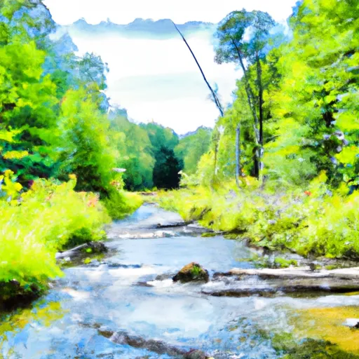
Some of the specific river rapids and obstacles that paddlers can expect to encounter on this run include "The Chutes," a series of class III rapids that require precise maneuvering to navigate, and "The Ledges," a series of drops and ledges that require careful scouting before running.
There are specific regulations that paddlers must follow when navigating this segment of the Whitewater River. Paddlers must obtain a permit from the Michigan Department of Natural Resources before accessing the river. Additionally, paddlers must wear personal flotation devices and follow all state regulations regarding the use of watercraft.
Overall, the Whitewater River run South Branch is a challenging and exciting run for intermediate kayakers and rafters. Paddlers should be prepared to navigate class II-III rapids, carefully scout obstacles, and follow all regulations to ensure a safe and enjoyable experience.
Plan your run down to the hour
Same weather feed Snoflo's iOS app uses -- updated continuously from NOAA / yr.no. Watch the precipitation column on the meteogram; rain ahead of a run typically lifts flows 12-48 hours later depending on the basin.
Next 5 days, hour by hour
Temperature line with weather symbols on top, snow + rain accumulation as columns, humidity as a dotted line.
5-day forecast table
Every 3 hours, broken out across temperature, snow, rain, humidity, and wind. Each cell is colour-coded relative to the column min/max.
| Time | Condition | Temp (°F) | Snow (in) | Rain (in) | Humidity (%) | Wind (mps) | Wind dir |
|---|---|---|---|---|---|---|---|
| Loading detailed forecast… | |||||||
15-day temperature & precipitation
Daily temperatures, snow, and rain projected over the next two weeks -- the upstream story that drives next week's flows.
Regional streamflow levels
USGS streamgauges around South Branch From Forest Boundary East Of Hesperia At West Section Line Of Sec 22, T14n, R14w To Echo Drive In Sec 6, T13n, R12w -- useful for spotting upstream pulses and gauging which tributary is contributing what.
| Streamgauge | Discharge | View |
|---|---|---|
| White River Near Whitehall | 256 cfs | → |
| Muskegon River Near Croton | 1,060 cfs | → |
| Little Muskegon River Near Oak Grove | 131 cfs | → |
| Bear Creek Near Muskegon | 4 cfs | → |
| Pere Marquette River At Scottville | 473 cfs | → |
| Rogue River Near Rockford | 101 cfs | → |
Plan a longer trip
The closest boat launches, other paddle runs, and campgrounds so a day on the water can grow into a full weekend.
Boat launches
- Peskin Drive Newfield Township
- Ramshorn Drive Fremont
- Robinson Lake
- Nfs 6902 Merrill Township
- Pine Point
- Diamond Lake
Other river runs
- North Branch From Its Confluence With South Branch In Sec 22, T13n, R16 W To Mclaren Lake In Sec 11, T14n, R15w
- Croton Dam In T12n, R11w To City Of Newaygo In T12n, R12w
- Morley Dam In T13n, R10w To Croton Dam Pond In T12n, R11w
- Mainstem To Forest Boundary At North Section Line Of Sec 2, T13n, R15w (1.5 Miles West Of Herperia)
- Kings Road Bridge (2 Miles West Of Town Of Luther In T19n, R12w To Slackwater Of The State Fish Weir In T21n, R16w
Campgrounds
- Timbers Edge Campground
- Minnie Pond
- Minnie Pond Campground
- Benton Lake Campground
- Benton Lake
- Pines Point
Fishing spots
- St. Hubert Angler Parking
- Blanch Lake
- Idlewild Lake
- Log Mark Rest Stop Canoe And Fishing Landing
- Baptist Lake
- Fishing Peir
Whitewater safety
- Check the flow before you run
- Use the linked-gauge card and Regional Flow panel above. Class ratings change with flow -- a Class III at low water can become Class IV+ at high water.
- Know your skill ceiling
- Pick runs comfortably below your ceiling. Cold-water and big-water runs raise the consequences of any mistake.
- Wear the right gear
- Helmet, PFD, drysuit / wetsuit when water is below 60°F. Throw bag, knife, and whistle on your person, not in the boat.
- Scout, set safety, and run with a team
- Scout new rapids on foot, set safety with throw bags above the consequence pool, and run with at least one other competent paddler.
- Respect the river
- Strainers, undercuts, low-head dams, and wood can kill at any class rating. When in doubt, portage.
Set push alerts in the Snoflo app
Save South Branch From Forest Boundary East Of Hesperia At West Section Line Of Sec 22, T14n, R14w To Echo Drive In Sec 6, T13n, R12w as a favorite, set a discharge threshold (e.g. "alert me when flow hits 600 cfs"), and the iOS app pushes the moment the linked gauge crosses.
About South Branch From Forest Boundary East Of Hesperia At West Section Line Of Sec 22, T14n, R14w To Echo Drive In Sec 6, T13n, R12w
What's the optimal flow for South Branch From Forest Boundary East Of Hesperia At West Section Line Of Sec 22, T14n, R14w To Echo Drive In Sec 6, T13n, R12w?
The optimal flow depends on the section and the craft. Check the Run Details panel for the linked gauge and current status.
How fresh is the cfs reading on this page?
The linked USGS streamgauge reports continuously (every 15 minutes); Snoflo refreshes throughout the day. Hover the streamflow sparkline to read individual datapoints.
What's the whitewater class?
See the Run Details panel for the class rating Snoflo tracks for this run. Class ratings change with flow -- a Class III at low water can become Class IV in high water.
Where do I put in / take out?
Tap Directions in the hero above to open driving directions to the put-in. For shuttle planning, check the Nearby Boat Launches panel and the river run operator's site.
Can I get alerts when flows hit the optimal range?
Yes -- alerts are managed in the Snoflo iOS app. Favorite this run, set a discharge threshold, and you'll get a push the moment the gauge crosses.
Other runs near here
Snoflo-tracked paddle runs within driving distance of South Branch From Forest Boundary East Of Hesperia At West Section Line Of Sec 22, T14n, R14w To Echo Drive In Sec 6, T13n, R12w.