Section 26, T65n, R17w To Section 31, T66n, R17w River Run
Community Reviews
Been here? Share the conditions.
Reviews, ratings & photos are added in the free Snoflo iOS app — rate a spot, tag the conditions, and your visit is verified by location. Add or manage your reviews from the app.
Section 26, T65n, R17w To Section 31, T66n, R17w
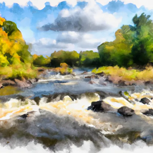
One of the most notable rapids on this run is called the "Double Drop," which is a Class III rapid that requires skilled maneuvering. Another challenging section is the "Devil's Elbow," which features a tight turn and steep drop.
There are specific regulations that apply to this area, including a catch-and-release policy for trout fishing and a ban on camping on the riverbanks. Additionally, all boaters are required to wear a personal flotation device and carry a whistle.
Overall, the Whitewater River run is a popular destination for paddlers looking for a mix of scenery and excitement. While the river is generally suitable for intermediate paddlers, it's important to be aware of the specific rapids and obstacles along the way, as well as any changing water conditions.
Plan your run down to the hour
Same weather feed Snoflo's iOS app uses -- updated continuously from NOAA / yr.no. Watch the precipitation column on the meteogram; rain ahead of a run typically lifts flows 12-48 hours later depending on the basin.
Next 5 days, hour by hour
Temperature line with weather symbols on top, snow + rain accumulation as columns, humidity as a dotted line.
5-day forecast table
Every 3 hours, broken out across temperature, snow, rain, humidity, and wind. Each cell is colour-coded relative to the column min/max.
| Time | Condition | Temp (°F) | Snow (in) | Rain (in) | Humidity (%) | Wind (mps) | Wind dir |
|---|---|---|---|---|---|---|---|
| Loading detailed forecast… | |||||||
15-day temperature & precipitation
Daily temperatures, snow, and rain projected over the next two weeks -- the upstream story that drives next week's flows.
Regional streamflow levels
USGS streamgauges around Section 26, T65n, R17w To Section 31, T66n, R17w -- useful for spotting upstream pulses and gauging which tributary is contributing what.
| Streamgauge | Discharge | View |
|---|---|---|
| Vermilion River Nr Crane Lake | 129 cfs | → |
| Gold Portage Outlet From Kabetogama Lk Nr Ray | 589 cfs | → |
| South Kawishiwi R Abv White Iron Lake Nr Ely | 130 cfs | → |
| Basswood River Near Winton | 456 cfs | → |
| Little Fork River At Littlefork | 90 cfs | → |
| South Kawishiwi River Near Ely | 88 cfs | → |
Plan a longer trip
The closest boat launches, other paddle runs, and campgrounds so a day on the water can grow into a full weekend.
Boat launches
- Echo Lake
- Crane Lake Road Saint Louis County
- Elephant Lake (Southeast)
- Myrtle Lake
- Pelican River (Northwest)
- Waters Edge
Other river runs
- Wolf Bay Of Lake Vermilion To Section 26, T65n, R17w
- Section 31, T66n, R17w To Crane Lake
- Dora Lake To State Highway 6
- The Confluence Of The Prairie River To The Boundary Of Logan And Workman Townships
- Bwcaw Boundary To Confluence With Plouff Creek
Whitewater safety
- Check the flow before you run
- Use the linked-gauge card and Regional Flow panel above. Class ratings change with flow -- a Class III at low water can become Class IV+ at high water.
- Know your skill ceiling
- Pick runs comfortably below your ceiling. Cold-water and big-water runs raise the consequences of any mistake.
- Wear the right gear
- Helmet, PFD, drysuit / wetsuit when water is below 60°F. Throw bag, knife, and whistle on your person, not in the boat.
- Scout, set safety, and run with a team
- Scout new rapids on foot, set safety with throw bags above the consequence pool, and run with at least one other competent paddler.
- Respect the river
- Strainers, undercuts, low-head dams, and wood can kill at any class rating. When in doubt, portage.
Set push alerts in the Snoflo app
Save Section 26, T65n, R17w To Section 31, T66n, R17w as a favorite, set a discharge threshold (e.g. "alert me when flow hits 600 cfs"), and the iOS app pushes the moment the linked gauge crosses.
About Section 26, T65n, R17w To Section 31, T66n, R17w
What's the optimal flow for Section 26, T65n, R17w To Section 31, T66n, R17w?
The optimal flow depends on the section and the craft. Check the Run Details panel for the linked gauge and current status.
How fresh is the cfs reading on this page?
The linked USGS streamgauge reports continuously (every 15 minutes); Snoflo refreshes throughout the day. Hover the streamflow sparkline to read individual datapoints.
What's the whitewater class?
See the Run Details panel for the class rating Snoflo tracks for this run. Class ratings change with flow -- a Class III at low water can become Class IV in high water.
Where do I put in / take out?
Tap Directions in the hero above to open driving directions to the put-in. For shuttle planning, check the Nearby Boat Launches panel and the river run operator's site.
Can I get alerts when flows hit the optimal range?
Yes -- alerts are managed in the Snoflo iOS app. Favorite this run, set a discharge threshold, and you'll get a push the moment the gauge crosses.
Other runs near here
Snoflo-tracked paddle runs within driving distance of Section 26, T65n, R17w To Section 31, T66n, R17w.