Pool Creek, Sec. 7, T28n, R12w To Falls, Sec. 25, T29n, R12w River Run
Community Reviews
Been here? Share the conditions.
Reviews, ratings & photos are added in the free Snoflo iOS app — rate a spot, tag the conditions, and your visit is verified by location. Add or manage your reviews from the app.
Pool Creek, Sec. 7, T28n, R12w To Falls, Sec. 25, T29n, R12w
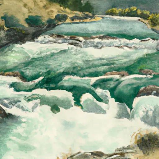
One of the most notable rapids on this run is the "Narrows," which is a narrow, technical rapid that requires precise maneuvering. Other rapids include "Pinball," "The Chute," and "The Squeeze." The run also features some beautiful scenery, with steep canyon walls and lush vegetation along the riverbanks.
There are specific regulations in place for this area, including a permit requirement for overnight camping and a limit of one group per day. Boaters are also required to pack out all trash and follow Leave No Trace principles to preserve the natural beauty of the area.
Overall, the Whitewater River Run from Pool Creek to Falls offers a thrilling whitewater experience for experienced paddlers during the spring runoff season, with challenging rapids and stunning scenery along the way.
Plan your run down to the hour
Same weather feed Snoflo's iOS app uses -- updated continuously from NOAA / yr.no. Watch the precipitation column on the meteogram; rain ahead of a run typically lifts flows 12-48 hours later depending on the basin.
Next 5 days, hour by hour
Temperature line with weather symbols on top, snow + rain accumulation as columns, humidity as a dotted line.
5-day forecast table
Every 3 hours, broken out across temperature, snow, rain, humidity, and wind. Each cell is colour-coded relative to the column min/max.
| Time | Condition | Temp (°F) | Snow (in) | Rain (in) | Humidity (%) | Wind (mps) | Wind dir |
|---|---|---|---|---|---|---|---|
| Loading detailed forecast… | |||||||
15-day temperature & precipitation
Daily temperatures, snow, and rain projected over the next two weeks -- the upstream story that drives next week's flows.
Regional streamflow levels
USGS streamgauges around Pool Creek, Sec. 7, T28n, R12w To Falls, Sec. 25, T29n, R12w -- useful for spotting upstream pulses and gauging which tributary is contributing what.
| Streamgauge | Discharge | View |
|---|---|---|
| Two Medicine River Bl South Fork Nr Browning Mt | 188 cfs | → |
| Badger Cr Bl Four Horns Canal Nr Browning Mt | 286 cfs | → |
| Cut Bank Creek Near Browning Mt | 60 cfs | → |
| S F Flathead R Ab Twin C Nr Hungry Horse Mt | 1,150 cfs | → |
| Teton River Bl South Fork Nr Choteau Mt | 145 cfs | → |
| St. Mary River Near Babb Mt | 1,270 cfs | → |
Plan a longer trip
The closest boat launches, other paddle runs, and campgrounds so a day on the water can grow into a full weekend.
Other river runs
- Headwaters, Sec. 34, T28n, R11w To Swift Reservoir
- Schafer Meadows To Bear Creek (Upper)
- Bear Creek To Essex
- Essex To Moccasin Creek
- Moccasin Creek To West Glacier (John Stevens Canyon)
Campgrounds
Fishing spots
Whitewater safety
- Check the flow before you run
- Use the linked-gauge card and Regional Flow panel above. Class ratings change with flow -- a Class III at low water can become Class IV+ at high water.
- Know your skill ceiling
- Pick runs comfortably below your ceiling. Cold-water and big-water runs raise the consequences of any mistake.
- Wear the right gear
- Helmet, PFD, drysuit / wetsuit when water is below 60°F. Throw bag, knife, and whistle on your person, not in the boat.
- Scout, set safety, and run with a team
- Scout new rapids on foot, set safety with throw bags above the consequence pool, and run with at least one other competent paddler.
- Respect the river
- Strainers, undercuts, low-head dams, and wood can kill at any class rating. When in doubt, portage.
Set push alerts in the Snoflo app
Save Pool Creek, Sec. 7, T28n, R12w To Falls, Sec. 25, T29n, R12w as a favorite, set a discharge threshold (e.g. "alert me when flow hits 600 cfs"), and the iOS app pushes the moment the linked gauge crosses.
About Pool Creek, Sec. 7, T28n, R12w To Falls, Sec. 25, T29n, R12w
What's the optimal flow for Pool Creek, Sec. 7, T28n, R12w To Falls, Sec. 25, T29n, R12w?
The optimal flow depends on the section and the craft. Check the Run Details panel for the linked gauge and current status.
How fresh is the cfs reading on this page?
The linked USGS streamgauge reports continuously (every 15 minutes); Snoflo refreshes throughout the day. Hover the streamflow sparkline to read individual datapoints.
What's the whitewater class?
See the Run Details panel for the class rating Snoflo tracks for this run. Class ratings change with flow -- a Class III at low water can become Class IV in high water.
Where do I put in / take out?
Tap Directions in the hero above to open driving directions to the put-in. For shuttle planning, check the Nearby Boat Launches panel and the river run operator's site.
Can I get alerts when flows hit the optimal range?
Yes -- alerts are managed in the Snoflo iOS app. Favorite this run, set a discharge threshold, and you'll get a push the moment the gauge crosses.
Other runs near here
Snoflo-tracked paddle runs within driving distance of Pool Creek, Sec. 7, T28n, R12w To Falls, Sec. 25, T29n, R12w.