Gallatin Canyon, Sec. 19, T4s, R4e To Yellowstone National Park, Sec. 27, T9s, R5e River Run
Community Reviews
Been here? Share the conditions.
Reviews, ratings & photos are added in the free Snoflo iOS app — rate a spot, tag the conditions, and your visit is verified by location. Add or manage your reviews from the app.
Gallatin Canyon, Sec. 19, T4s, R4e To Yellowstone National Park, Sec. 27, T9s, R5e
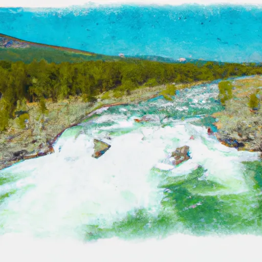
The whitewater river run from Gallatin Canyon to Yellowstone National Park in Montana is an exciting and popular adventure for rafters and kayakers. The ideal streamflow range for this stretch of river is between 2,500 and 5,000 cfs. The river is rated as a class II-III rapids, making it suitable for intermediate-level paddlers.
The segment mileage for this run is approximately 70 miles, and it includes several notable rapids and obstacles. Some of the most challenging rapids include House Rock, Kitchen Sink, and Zigzag. There are also several sections of calm water that allow paddlers to relax and take in the beautiful scenery.
Specific regulations for this area include a required permit for all commercial outfitters operating on the river. Private paddlers are not required to obtain a permit, but they must follow all state and federal regulations, including wearing proper safety equipment and adhering to all speed limits and other boating laws.
Plan your run down to the hour
Same weather feed Snoflo's iOS app uses -- updated continuously from NOAA / yr.no. Watch the precipitation column on the meteogram; rain ahead of a run typically lifts flows 12-48 hours later depending on the basin.
Next 5 days, hour by hour
Temperature line with weather symbols on top, snow + rain accumulation as columns, humidity as a dotted line.
5-day forecast table
Every 3 hours, broken out across temperature, snow, rain, humidity, and wind. Each cell is colour-coded relative to the column min/max.
| Time | Condition | Temp (°F) | Snow (in) | Rain (in) | Humidity (%) | Wind (mps) | Wind dir |
|---|---|---|---|---|---|---|---|
| Loading detailed forecast… | |||||||
15-day temperature & precipitation
Daily temperatures, snow, and rain projected over the next two weeks -- the upstream story that drives next week's flows.
Regional streamflow levels
USGS streamgauges around Gallatin Canyon, Sec. 19, T4s, R4e To Yellowstone National Park, Sec. 27, T9s, R5e -- useful for spotting upstream pulses and gauging which tributary is contributing what.
| Streamgauge | Discharge | View |
|---|---|---|
| Madison River Bl Hebgen Lake Nr Grayling Mt | 1,200 cfs | → |
| Yellowstone River At Corwin Springs Mt | 3,760 cfs | → |
| Gardner River Near Mammoth Ynp | 181 cfs | → |
| Boiling River At Mammoth | 22 cfs | → |
| Madison River At Kirby Ranch Nr Cameron Mt | 1,400 cfs | → |
| Madison River Near West Yellowstone Mt | 363 cfs | → |
Plan a longer trip
The closest boat launches, other paddle runs, and campgrounds so a day on the water can grow into a full weekend.
Boat launches
- Kirkwood Marina
- Carbella Boat Ramp
- Old Yellowstone Trail Park County
- Yellowstone
- Quake Lake Boat Launch
- Madison County
Other river runs
- Begins Where The River Parallels A Two-Lane Highway To The Western Boundary Of Yellowstone National Park
- The Headwaters, In The Gallatin Range To Ends Downstream Of Osprey Falls
- Gallatin Forest Boundary, Sec. 32, T7s, R7e To Yellowstone National Park, Sec. 23, T9s, R8e
- Yankee Jim Canyon (Joe Brown To Miner)
- The Headwaters In The Gallatin Range To Ends Where The River Parallels A Two-Lane Highway
Campgrounds
Fishing spots
Whitewater safety
- Check the flow before you run
- Use the linked-gauge card and Regional Flow panel above. Class ratings change with flow -- a Class III at low water can become Class IV+ at high water.
- Know your skill ceiling
- Pick runs comfortably below your ceiling. Cold-water and big-water runs raise the consequences of any mistake.
- Wear the right gear
- Helmet, PFD, drysuit / wetsuit when water is below 60°F. Throw bag, knife, and whistle on your person, not in the boat.
- Scout, set safety, and run with a team
- Scout new rapids on foot, set safety with throw bags above the consequence pool, and run with at least one other competent paddler.
- Respect the river
- Strainers, undercuts, low-head dams, and wood can kill at any class rating. When in doubt, portage.
Set push alerts in the Snoflo app
Save Gallatin Canyon, Sec. 19, T4s, R4e To Yellowstone National Park, Sec. 27, T9s, R5e as a favorite, set a discharge threshold (e.g. "alert me when flow hits 600 cfs"), and the iOS app pushes the moment the linked gauge crosses.
About Gallatin Canyon, Sec. 19, T4s, R4e To Yellowstone National Park, Sec. 27, T9s, R5e
What's the optimal flow for Gallatin Canyon, Sec. 19, T4s, R4e To Yellowstone National Park, Sec. 27, T9s, R5e?
The optimal flow depends on the section and the craft. Check the Run Details panel for the linked gauge and current status.
How fresh is the cfs reading on this page?
The linked USGS streamgauge reports continuously (every 15 minutes); Snoflo refreshes throughout the day. Hover the streamflow sparkline to read individual datapoints.
What's the whitewater class?
See the Run Details panel for the class rating Snoflo tracks for this run. Class ratings change with flow -- a Class III at low water can become Class IV in high water.
Where do I put in / take out?
Tap Directions in the hero above to open driving directions to the put-in. For shuttle planning, check the Nearby Boat Launches panel and the river run operator's site.
Can I get alerts when flows hit the optimal range?
Yes -- alerts are managed in the Snoflo iOS app. Favorite this run, set a discharge threshold, and you'll get a push the moment the gauge crosses.
Other runs near here
Snoflo-tracked paddle runs within driving distance of Gallatin Canyon, Sec. 19, T4s, R4e To Yellowstone National Park, Sec. 27, T9s, R5e.