Nez Perce Fork Bitterroot River, Sec. 26, T1s, R22w To Painted Rocks Dam, Sec. 26, T1s, R22w River Run
Community Reviews
Been here? Share the conditions.
Reviews, ratings & photos are added in the free Snoflo iOS app — rate a spot, tag the conditions, and your visit is verified by location. Add or manage your reviews from the app.
Nez Perce Fork Bitterroot River, Sec. 26, T1s, R22w To Painted Rocks Dam, Sec. 26, T1s, R22w
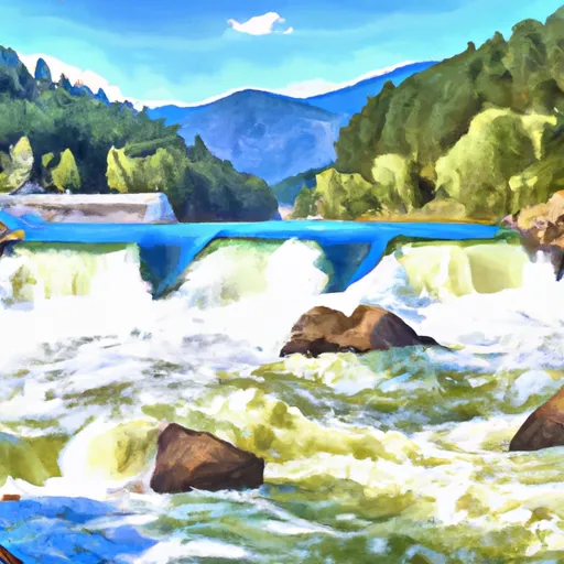
The Nez Perce Fork Bitterroot River is a popular whitewater river run in Montana. The ideal streamflow range for this run is between 100 and 600 cubic feet per second (cfs), with peak flows occurring in May and June due to snowmelt. The run is rated Class II-III, with occasional class IV rapids during high water.
The segment mileage of the run is approximately 20 miles, starting at Sec. 26, T1S, R22W and ending at Painted Rocks Dam, Sec. 26, T1S, R22W. The river runs through a scenic, forested canyon with views of the Bitterroot Mountains.
Specific river rapids and obstacles include the "Roaring Lion" rapids, a series of class III rapids with boulder gardens and strong currents. Other notable rapids include "Little Willow" and "Kootenai". The run also features several shallow rocky sections that require careful navigation.
Regulations for the area include a requirement for a Montana Fishing License, as well as restrictions on camping and campfires. Additionally, boaters are required to wear personal flotation devices (PFDs) at all times.
Plan your run down to the hour
Same weather feed Snoflo's iOS app uses -- updated continuously from NOAA / yr.no. Watch the precipitation column on the meteogram; rain ahead of a run typically lifts flows 12-48 hours later depending on the basin.
Next 5 days, hour by hour
Temperature line with weather symbols on top, snow + rain accumulation as columns, humidity as a dotted line.
5-day forecast table
Every 3 hours, broken out across temperature, snow, rain, humidity, and wind. Each cell is colour-coded relative to the column min/max.
| Time | Condition | Temp (°F) | Snow (in) | Rain (in) | Humidity (%) | Wind (mps) | Wind dir |
|---|---|---|---|---|---|---|---|
| Loading detailed forecast… | |||||||
15-day temperature & precipitation
Daily temperatures, snow, and rain projected over the next two weeks -- the upstream story that drives next week's flows.
Regional streamflow levels
USGS streamgauges around Nez Perce Fork Bitterroot River, Sec. 26, T1s, R22w To Painted Rocks Dam, Sec. 26, T1s, R22w -- useful for spotting upstream pulses and gauging which tributary is contributing what.
| Streamgauge | Discharge | View |
|---|---|---|
| West Fork Bitterroot River Nr Conner Mt | 135 cfs | → |
| Bitterroot River Near Darby Mt | 411 cfs | → |
| Salmon River Nr Shoup Id | 1,950 cfs | → |
| Middle Fork Salmon River At Mouth Nr Shoup Id | 1,700 cfs | → |
| Napias Creek Below Arnett Creek Near Leesburg | 22 cfs | → |
| Big Hole River Bl Big Lake Cr At Wisdom Mt | 52 cfs | → |
Plan a longer trip
The closest boat launches, other paddle runs, and campgrounds so a day on the water can grow into a full weekend.
Boat launches
- West Fork Boating Site
- Applebury Boating Site
- Painted Rocks State Park - Slate Creek
- Ww White Memorial
- Rocky Mountain Road Ravalli County
- Darby Boat Ramp
Other river runs
- Lick Creek Bridge, Sec. 18, T4n, R21w To Bear Creek Pass, Sec. 5, T4n, R23w And Twin Lakes Dam, Sec. 29, T5n, R23w
- Paradise To Selway Falls
- Sec. 28, T30n, R13e To Boundary Selway-Bitterroot Wilderness
- Wilderness Boundary To Headwaters
- Selway River, Sec. 16, T31n, R13e To Headwaters
Whitewater safety
- Check the flow before you run
- Use the linked-gauge card and Regional Flow panel above. Class ratings change with flow -- a Class III at low water can become Class IV+ at high water.
- Know your skill ceiling
- Pick runs comfortably below your ceiling. Cold-water and big-water runs raise the consequences of any mistake.
- Wear the right gear
- Helmet, PFD, drysuit / wetsuit when water is below 60°F. Throw bag, knife, and whistle on your person, not in the boat.
- Scout, set safety, and run with a team
- Scout new rapids on foot, set safety with throw bags above the consequence pool, and run with at least one other competent paddler.
- Respect the river
- Strainers, undercuts, low-head dams, and wood can kill at any class rating. When in doubt, portage.
Set push alerts in the Snoflo app
Save Nez Perce Fork Bitterroot River, Sec. 26, T1s, R22w To Painted Rocks Dam, Sec. 26, T1s, R22w as a favorite, set a discharge threshold (e.g. "alert me when flow hits 600 cfs"), and the iOS app pushes the moment the linked gauge crosses.
About Nez Perce Fork Bitterroot River, Sec. 26, T1s, R22w To Painted Rocks Dam, Sec. 26, T1s, R22w
What's the optimal flow for Nez Perce Fork Bitterroot River, Sec. 26, T1s, R22w To Painted Rocks Dam, Sec. 26, T1s, R22w?
The optimal flow depends on the section and the craft. Check the Run Details panel for the linked gauge and current status.
How fresh is the cfs reading on this page?
The linked USGS streamgauge reports continuously (every 15 minutes); Snoflo refreshes throughout the day. Hover the streamflow sparkline to read individual datapoints.
What's the whitewater class?
See the Run Details panel for the class rating Snoflo tracks for this run. Class ratings change with flow -- a Class III at low water can become Class IV in high water.
Where do I put in / take out?
Tap Directions in the hero above to open driving directions to the put-in. For shuttle planning, check the Nearby Boat Launches panel and the river run operator's site.
Can I get alerts when flows hit the optimal range?
Yes -- alerts are managed in the Snoflo iOS app. Favorite this run, set a discharge threshold, and you'll get a push the moment the gauge crosses.
Other runs near here
Snoflo-tracked paddle runs within driving distance of Nez Perce Fork Bitterroot River, Sec. 26, T1s, R22w To Painted Rocks Dam, Sec. 26, T1s, R22w.