Big Sheep Creek River Run
Community Reviews
Been here? Share the conditions.
Reviews, ratings & photos are added in the free Snoflo iOS app — rate a spot, tag the conditions, and your visit is verified by location. Add or manage your reviews from the app.
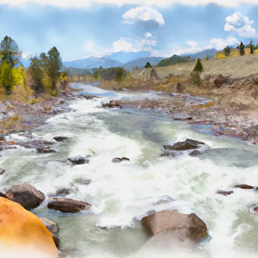
Big Sheep Creek
Big Sheep Creek is a popular river for whitewater rafting and kayaking in Montana. The ideal streamflow range for this river is between 500 and 2,000 cubic feet per second (cfs). The river is classified as a Class III to IV, depending on the water levels. The segment mileage of the Big Sheep Creek is approximately 13 miles, which can usually be completed in one day.
The river features several challenging rapids, including Pinball, The Slot, and The Ledge. These rapids require skill and experience to navigate safely. The river also has some obstacles, including trees, rocks, and narrow channels, which add to the excitement of the run.
Specific regulations to the area include a permit requirement for commercial outfitters and a limit on the number of visitors allowed in the area at any given time. Additionally, visitors are required to follow Leave No Trace principles and pack out all trash and waste.
In summary, Big Sheep Creek in Montana is a challenging and exciting river for experienced whitewater rafters and kayakers. With its Class III to IV rating, specific rapids and obstacles, and regulations to protect the area, it offers a unique and rewarding adventure for those who seek it.
Plan your run down to the hour
Same weather feed Snoflo's iOS app uses -- updated continuously from NOAA / yr.no. Watch the precipitation column on the meteogram; rain ahead of a run typically lifts flows 12-48 hours later depending on the basin.
Next 5 days, hour by hour
Temperature line with weather symbols on top, snow + rain accumulation as columns, humidity as a dotted line.
5-day forecast table
Every 3 hours, broken out across temperature, snow, rain, humidity, and wind. Each cell is colour-coded relative to the column min/max.
| Time | Condition | Temp (°F) | Snow (in) | Rain (in) | Humidity (%) | Wind (mps) | Wind dir |
|---|---|---|---|---|---|---|---|
| Loading detailed forecast… | |||||||
15-day temperature & precipitation
Daily temperatures, snow, and rain projected over the next two weeks -- the upstream story that drives next week's flows.
Regional streamflow levels
USGS streamgauges around Big Sheep Creek -- useful for spotting upstream pulses and gauging which tributary is contributing what.
| Streamgauge | Discharge | View |
|---|---|---|
| Red Rock R Bl Lima Reservoir Nr Monida Mt | 44 cfs | → |
| Medicine Lodge Creek Nr Small Id | 26 cfs | → |
| Beaver Creek At Spencer Id 12n-36e-23a | 22 cfs | → |
| Little Lost River Bl Wet Creek Nr Howe Id | 54 cfs | → |
| Beaverhead River At Barretts Mt | 547 cfs | → |
| Beaverhead River At Dillon Mt | 137 cfs | → |
Plan a longer trip
The closest boat launches, other paddle runs, and campgrounds so a day on the water can grow into a full weekend.
Whitewater safety
- Check the flow before you run
- Use the linked-gauge card and Regional Flow panel above. Class ratings change with flow -- a Class III at low water can become Class IV+ at high water.
- Know your skill ceiling
- Pick runs comfortably below your ceiling. Cold-water and big-water runs raise the consequences of any mistake.
- Wear the right gear
- Helmet, PFD, drysuit / wetsuit when water is below 60°F. Throw bag, knife, and whistle on your person, not in the boat.
- Scout, set safety, and run with a team
- Scout new rapids on foot, set safety with throw bags above the consequence pool, and run with at least one other competent paddler.
- Respect the river
- Strainers, undercuts, low-head dams, and wood can kill at any class rating. When in doubt, portage.
Set push alerts in the Snoflo app
Save Big Sheep Creek as a favorite, set a discharge threshold (e.g. "alert me when flow hits 600 cfs"), and the iOS app pushes the moment the linked gauge crosses.
About Big Sheep Creek
What's the optimal flow for Big Sheep Creek?
The optimal flow depends on the section and the craft. Check the Run Details panel for the linked gauge and current status.
How fresh is the cfs reading on this page?
The linked USGS streamgauge reports continuously (every 15 minutes); Snoflo refreshes throughout the day. Hover the streamflow sparkline to read individual datapoints.
What's the whitewater class?
See the Run Details panel for the class rating Snoflo tracks for this run. Class ratings change with flow -- a Class III at low water can become Class IV in high water.
Where do I put in / take out?
Tap Directions in the hero above to open driving directions to the put-in. For shuttle planning, check the Nearby Boat Launches panel and the river run operator's site.
Can I get alerts when flows hit the optimal range?
Yes -- alerts are managed in the Snoflo iOS app. Favorite this run, set a discharge threshold, and you'll get a push the moment the gauge crosses.
Other runs near here
Snoflo-tracked paddle runs within driving distance of Big Sheep Creek.