Marias River River Run
Community Reviews
Been here? Share the conditions.
Reviews, ratings & photos are added in the free Snoflo iOS app — rate a spot, tag the conditions, and your visit is verified by location. Add or manage your reviews from the app.
Marias River
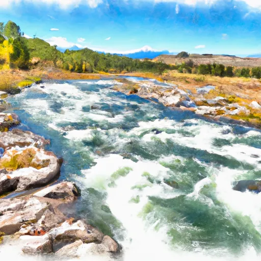
The Marias River is a popular whitewater river run in Montana that offers an exciting and challenging adventure for kayakers and rafters. The ideal streamflow range for the Marias River is between 500 and 2000 cubic feet per second (cfs), which typically occurs in the spring and early summer months. The river is rated as a Class II-III, with some rapids and obstacles that require technical skill and precision.
The Marias River has a total segment mileage of 125 miles, stretching from the foothills of the Rocky Mountains to its confluence with the Missouri River. The upper segment of the river, from the headwaters to the Tiber Dam, is often calmer and more suitable for beginners. The lower segment, from the dam to the Missouri River, is wilder and more challenging, with steep drops and tight turns.
One of the most challenging rapids on the Marias River is the "Needle's Eye," which requires precise maneuvering through a narrow channel between two large boulders. The "S-Turn" is another difficult obstacle, featuring a sharp turn that can cause boats to capsize if not navigated correctly.
There are specific regulations to the area that need to be followed. For example, all boaters must obtain a permit from the Bureau of Land Management before launching on the river. Additionally, there are restrictions on camping, fires, and littering to preserve the natural beauty of the area.
Overall, the Marias River offers an exhilarating experience for whitewater enthusiasts, with challenging rapids and stunning scenery. However, it is important to follow regulations and safety guidelines to ensure a safe and enjoyable trip.
Plan your run down to the hour
Same weather feed Snoflo's iOS app uses -- updated continuously from NOAA / yr.no. Watch the precipitation column on the meteogram; rain ahead of a run typically lifts flows 12-48 hours later depending on the basin.
Next 5 days, hour by hour
Temperature line with weather symbols on top, snow + rain accumulation as columns, humidity as a dotted line.
5-day forecast table
Every 3 hours, broken out across temperature, snow, rain, humidity, and wind. Each cell is colour-coded relative to the column min/max.
| Time | Condition | Temp (°F) | Snow (in) | Rain (in) | Humidity (%) | Wind (mps) | Wind dir |
|---|---|---|---|---|---|---|---|
| Loading detailed forecast… | |||||||
15-day temperature & precipitation
Daily temperatures, snow, and rain projected over the next two weeks -- the upstream story that drives next week's flows.
Regional streamflow levels
USGS streamgauges around Marias River -- useful for spotting upstream pulses and gauging which tributary is contributing what.
| Streamgauge | Discharge | View |
|---|---|---|
| Teton River At Loma Mt | 15 cfs | → |
| Marias River Near Loma Mt | 1,430 cfs | → |
| Missouri River At Fort Benton Mt | 5,180 cfs | → |
| Missouri River At Virgelle Mt | 5,730 cfs | → |
| Missouri River Near Great Falls Mt | 4,480 cfs | → |
| Marias River Near Chester Mt | 1,550 cfs | → |
Plan a longer trip
The closest boat launches, other paddle runs, and campgrounds so a day on the water can grow into a full weekend.
Boat launches
- Loma Bridge
- Wood Bottom Recreation Area
- Seineurs Reach
- Coal Banks Landing
- Little Sandy Coulee Rec Site
- Lone Tree Coulee
Other river runs
- Tenderfoot Creek, Sec. 30, T14n, R4e To Deep Creek, Sec. 31, T16n, R4e
- Arch Coulee Junction, Sec. 32, T13n, R11e To Forest Boundary, Sec. 35, T13n, R11e
- Falls, Sec. 25, T14n, R4e To Smith River, Sec. 25, T14n, R3e
- Camp Baker To Eden Bridge
- Missouri River
Campgrounds
- Wood Bottom Recreation Area
- Wood Bottom Recreation Area - Umrbnm
- Wood Bottom
- Black Bluff Rapids
- Seineurs Reach
- Evans Bend
Fishing spots
Whitewater safety
- Check the flow before you run
- Use the linked-gauge card and Regional Flow panel above. Class ratings change with flow -- a Class III at low water can become Class IV+ at high water.
- Know your skill ceiling
- Pick runs comfortably below your ceiling. Cold-water and big-water runs raise the consequences of any mistake.
- Wear the right gear
- Helmet, PFD, drysuit / wetsuit when water is below 60°F. Throw bag, knife, and whistle on your person, not in the boat.
- Scout, set safety, and run with a team
- Scout new rapids on foot, set safety with throw bags above the consequence pool, and run with at least one other competent paddler.
- Respect the river
- Strainers, undercuts, low-head dams, and wood can kill at any class rating. When in doubt, portage.
Set push alerts in the Snoflo app
Save Marias River as a favorite, set a discharge threshold (e.g. "alert me when flow hits 600 cfs"), and the iOS app pushes the moment the linked gauge crosses.
About Marias River
What's the optimal flow for Marias River?
The optimal flow depends on the section and the craft. Check the Run Details panel for the linked gauge and current status.
How fresh is the cfs reading on this page?
The linked USGS streamgauge reports continuously (every 15 minutes); Snoflo refreshes throughout the day. Hover the streamflow sparkline to read individual datapoints.
What's the whitewater class?
See the Run Details panel for the class rating Snoflo tracks for this run. Class ratings change with flow -- a Class III at low water can become Class IV in high water.
Where do I put in / take out?
Tap Directions in the hero above to open driving directions to the put-in. For shuttle planning, check the Nearby Boat Launches panel and the river run operator's site.
Can I get alerts when flows hit the optimal range?
Yes -- alerts are managed in the Snoflo iOS app. Favorite this run, set a discharge threshold, and you'll get a push the moment the gauge crosses.
Other runs near here
Snoflo-tracked paddle runs within driving distance of Marias River.