Madison River River Run
Community Reviews
Been here? Share the conditions.
Reviews, ratings & photos are added in the free Snoflo iOS app — rate a spot, tag the conditions, and your visit is verified by location. Add or manage your reviews from the app.
Madison River
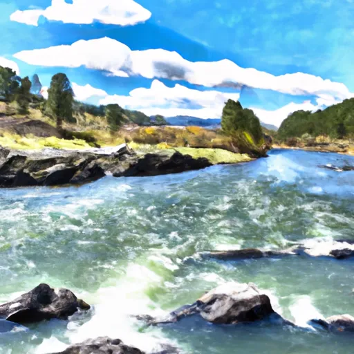
The Madison River is divided into three segments for recreational use: the Upper Madison, the Middle Madison, and the Lower Madison. The Upper Madison is the most challenging section of the river with Class III rapids such as "Kitchen Sink" and "Bear Trap Canyon." The Middle Madison has more moderate rapids with Class II and III features, while the Lower Madison is the most beginner-friendly section with Class I and II rapids.
Specific regulations for the Madison River include catch-and-release fishing for trout and a daily limit of two fish per person for non-native species. Additionally, all watercraft must be inspected for invasive species before entering the river to prevent the spread of zebra mussels and other harmful organisms.
Overall, the Madison River is a great whitewater river run for experienced and novice paddlers alike. With its ideal streamflow range, class rating, segment mileage, and specific regulations, the Madison River is a must-visit destination for anyone seeking an exciting and scenic whitewater adventure in Montana.
Plan your run down to the hour
Same weather feed Snoflo's iOS app uses -- updated continuously from NOAA / yr.no. Watch the precipitation column on the meteogram; rain ahead of a run typically lifts flows 12-48 hours later depending on the basin.
Next 5 days, hour by hour
Temperature line with weather symbols on top, snow + rain accumulation as columns, humidity as a dotted line.
5-day forecast table
Every 3 hours, broken out across temperature, snow, rain, humidity, and wind. Each cell is colour-coded relative to the column min/max.
| Time | Condition | Temp (°F) | Snow (in) | Rain (in) | Humidity (%) | Wind (mps) | Wind dir |
|---|---|---|---|---|---|---|---|
| Loading detailed forecast… | |||||||
15-day temperature & precipitation
Daily temperatures, snow, and rain projected over the next two weeks -- the upstream story that drives next week's flows.
Regional streamflow levels
USGS streamgauges around Madison River -- useful for spotting upstream pulses and gauging which tributary is contributing what.
| Streamgauge | Discharge | View |
|---|---|---|
| Madison River Bl Ennis Lake Nr Mcallister Mt | 1,180 cfs | → |
| Madison River Ab Powerplant Nr Mcallister Mt | 251 cfs | → |
| Willow Creek Near Harrison Mt | 20 cfs | → |
| Gallatin River Near Gallatin Gateway Mt | 771 cfs | → |
| Gallatin River At Logan Mt | 503 cfs | → |
| Jefferson River Near Three Forks Mt | 825 cfs | → |
Plan a longer trip
The closest boat launches, other paddle runs, and campgrounds so a day on the water can grow into a full weekend.
Boat launches
- Madison Road 18367, Gallatin County
- Mt 84 Gallatin County
- Canaday Boat Launch
- Warm Springs Day Use
- Greycliff
- Montana Highway 84 Madison County
Campgrounds
- Trapper Springs Rec Site
- Lee Metcalf Wilderness
- Harrison Lake Fas
- Spanish Creek Cabin
- Potosi Campground And Picnic Area
Whitewater safety
- Check the flow before you run
- Use the linked-gauge card and Regional Flow panel above. Class ratings change with flow -- a Class III at low water can become Class IV+ at high water.
- Know your skill ceiling
- Pick runs comfortably below your ceiling. Cold-water and big-water runs raise the consequences of any mistake.
- Wear the right gear
- Helmet, PFD, drysuit / wetsuit when water is below 60°F. Throw bag, knife, and whistle on your person, not in the boat.
- Scout, set safety, and run with a team
- Scout new rapids on foot, set safety with throw bags above the consequence pool, and run with at least one other competent paddler.
- Respect the river
- Strainers, undercuts, low-head dams, and wood can kill at any class rating. When in doubt, portage.
Set push alerts in the Snoflo app
Save Madison River as a favorite, set a discharge threshold (e.g. "alert me when flow hits 600 cfs"), and the iOS app pushes the moment the linked gauge crosses.
About Madison River
What's the optimal flow for Madison River?
The optimal flow depends on the section and the craft. Check the Run Details panel for the linked gauge and current status.
How fresh is the cfs reading on this page?
The linked USGS streamgauge reports continuously (every 15 minutes); Snoflo refreshes throughout the day. Hover the streamflow sparkline to read individual datapoints.
What's the whitewater class?
See the Run Details panel for the class rating Snoflo tracks for this run. Class ratings change with flow -- a Class III at low water can become Class IV in high water.
Where do I put in / take out?
Tap Directions in the hero above to open driving directions to the put-in. For shuttle planning, check the Nearby Boat Launches panel and the river run operator's site.
Can I get alerts when flows hit the optimal range?
Yes -- alerts are managed in the Snoflo iOS app. Favorite this run, set a discharge threshold, and you'll get a push the moment the gauge crosses.
Other runs near here
Snoflo-tracked paddle runs within driving distance of Madison River.