Clarks Fork Of The Yellowstone River Run
Community Reviews
Been here? Share the conditions.
Reviews, ratings & photos are added in the free Snoflo iOS app — rate a spot, tag the conditions, and your visit is verified by location. Add or manage your reviews from the app.
Clarks Fork Of The Yellowstone
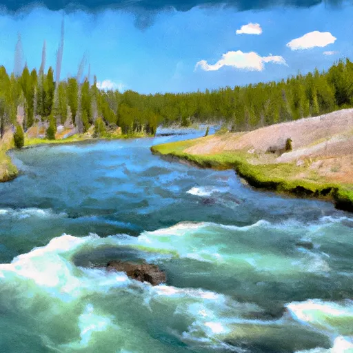
There are several specific rapids and obstacles to look out for when running the Clarks Fork, including the Devil's Elbow, the Big Timber Rapid, and the Jaws of Death. These rapids are known for their steep drops and powerful currents, making them a thrilling challenge for experienced whitewater enthusiasts.
It is important to note that there are specific regulations in place for the Clarks Fork of the Yellowstone. All boaters are required to obtain a permit from the Forest Service before embarking on the river, and there are restrictions on the number of people allowed in each group. Additionally, all boaters must wear appropriate safety gear, including helmets and life jackets.
Overall, the Clarks Fork of the Yellowstone is a challenging and exhilarating whitewater river run in Montana, with specific regulations in place to ensure both safety and preservation of the natural environment.
Plan your run down to the hour
Same weather feed Snoflo's iOS app uses -- updated continuously from NOAA / yr.no. Watch the precipitation column on the meteogram; rain ahead of a run typically lifts flows 12-48 hours later depending on the basin.
Next 5 days, hour by hour
Temperature line with weather symbols on top, snow + rain accumulation as columns, humidity as a dotted line.
5-day forecast table
Every 3 hours, broken out across temperature, snow, rain, humidity, and wind. Each cell is colour-coded relative to the column min/max.
| Time | Condition | Temp (°F) | Snow (in) | Rain (in) | Humidity (%) | Wind (mps) | Wind dir |
|---|---|---|---|---|---|---|---|
| Loading detailed forecast… | |||||||
15-day temperature & precipitation
Daily temperatures, snow, and rain projected over the next two weeks -- the upstream story that drives next week's flows.
Regional streamflow levels
USGS streamgauges around Clarks Fork Of The Yellowstone -- useful for spotting upstream pulses and gauging which tributary is contributing what.
| Streamgauge | Discharge | View |
|---|---|---|
| Rock Creek Near Red Lodge Mt | 390 cfs | → |
| Clarks Fork Yellowstone River Nr Belfry Mt | 1,210 cfs | → |
| Shoshone River Below Buffalo Bill Reservoir | 315 cfs | → |
| North Fork Shoshone River At Wapiti | 859 cfs | → |
| South Fork Shoshone River Ab Buffalo Bill Res | 641 cfs | → |
| West Rosebud Creek Near Roscoe Mt | 375 cfs | → |
Plan a longer trip
The closest boat launches, other paddle runs, and campgrounds so a day on the water can grow into a full weekend.
Boat launches
- Clarks Fork Boat Launch
- Hogan Reservoir Boat Launch
- Luce Reservoir Boat Launch
- Beartooth High Lakes Trail Wyoming
- Beartooth Highway Wyoming
Campgrounds
- Hogan And Luce Campsite 5
- Hogan And Luce Campsite 4
- Hogan And Luce Campsite 3
- Hogan And Luce Campsite 2
- Hogan And Luce Campsite 1
- Hogan And Luce Campground
Fishing spots
Whitewater safety
- Check the flow before you run
- Use the linked-gauge card and Regional Flow panel above. Class ratings change with flow -- a Class III at low water can become Class IV+ at high water.
- Know your skill ceiling
- Pick runs comfortably below your ceiling. Cold-water and big-water runs raise the consequences of any mistake.
- Wear the right gear
- Helmet, PFD, drysuit / wetsuit when water is below 60°F. Throw bag, knife, and whistle on your person, not in the boat.
- Scout, set safety, and run with a team
- Scout new rapids on foot, set safety with throw bags above the consequence pool, and run with at least one other competent paddler.
- Respect the river
- Strainers, undercuts, low-head dams, and wood can kill at any class rating. When in doubt, portage.
Set push alerts in the Snoflo app
Save Clarks Fork Of The Yellowstone as a favorite, set a discharge threshold (e.g. "alert me when flow hits 600 cfs"), and the iOS app pushes the moment the linked gauge crosses.
About Clarks Fork Of The Yellowstone
What's the optimal flow for Clarks Fork Of The Yellowstone?
The optimal flow depends on the section and the craft. Check the Run Details panel for the linked gauge and current status.
How fresh is the cfs reading on this page?
The linked USGS streamgauge reports continuously (every 15 minutes); Snoflo refreshes throughout the day. Hover the streamflow sparkline to read individual datapoints.
What's the whitewater class?
See the Run Details panel for the class rating Snoflo tracks for this run. Class ratings change with flow -- a Class III at low water can become Class IV in high water.
Where do I put in / take out?
Tap Directions in the hero above to open driving directions to the put-in. For shuttle planning, check the Nearby Boat Launches panel and the river run operator's site.
Can I get alerts when flows hit the optimal range?
Yes -- alerts are managed in the Snoflo iOS app. Favorite this run, set a discharge threshold, and you'll get a push the moment the gauge crosses.
Other runs near here
Snoflo-tracked paddle runs within driving distance of Clarks Fork Of The Yellowstone.