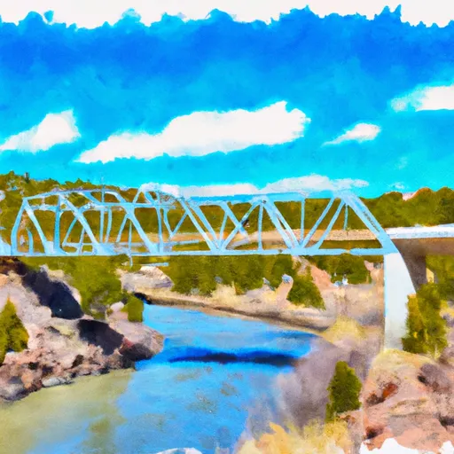
Fr 106 Bridge To Confluence With Rio Chama River Run
Community Reviews
Been here? Share the conditions.
Reviews, ratings & photos are added in the free Snoflo iOS app — rate a spot, tag the conditions, and your visit is verified by location. Add or manage your reviews from the app.
Fr 106 Bridge To Confluence With Rio Chama
The total mileage for this segment of the river is approximately 13 miles, with several notable rapids and obstacles along the way. Some of the most challenging rapids include Entrada, Beaver Slides, and the Narrows. In addition, there are several large boulders and tight turns that add to the excitement of the run.
As with all whitewater rafting destinations, there are specific regulations and guidelines that must be followed in order to ensure the safety of all participants. Some of the regulations for this area include wearing a personal flotation device (PFD) at all times while on the river, following all posted speed limits, and avoiding alcohol consumption before or during the trip.
Overall, the Whitewater River Run FR 106 Bridge to Confluence with Rio Chama is a thrilling and challenging whitewater rafting destination in New Mexico, with plenty of exciting rapids and obstacles to navigate. However, it is important to be aware of the ideal streamflow range, class rating, segment mileage, and specific regulations in order to have a safe and enjoyable trip.
Plan your run down to the hour
Same weather feed Snoflo's iOS app uses -- updated continuously from NOAA / yr.no. Watch the precipitation column on the meteogram; rain ahead of a run typically lifts flows 12-48 hours later depending on the basin.
Next 5 days, hour by hour
Temperature line with weather symbols on top, snow + rain accumulation as columns, humidity as a dotted line.
5-day forecast table
Every 3 hours, broken out across temperature, snow, rain, humidity, and wind. Each cell is colour-coded relative to the column min/max.
| Time | Condition | Temp (°F) | Snow (in) | Rain (in) | Humidity (%) | Wind (mps) | Wind dir |
|---|---|---|---|---|---|---|---|
| Loading detailed forecast… | |||||||
15-day temperature & precipitation
Daily temperatures, snow, and rain projected over the next two weeks -- the upstream story that drives next week's flows.
Regional streamflow levels
USGS streamgauges around Fr 106 Bridge To Confluence With Rio Chama -- useful for spotting upstream pulses and gauging which tributary is contributing what.
| Streamgauge | Discharge | View |
|---|---|---|
| Rio Chama Near Chamita | 140 cfs | → |
| Rio Chama Below Abiquiu Dam | 120 cfs | → |
| Rio Grande At Embudo | 150 cfs | → |
| Rio Ojo Caliente At La Madera | 4 cfs | → |
| Embudo Creek At Dixon | 1 cfs | → |
| Rio Chama Above Abiquiu Reservoir | 183 cfs | → |
Plan a longer trip
The closest boat launches, other paddle runs, and campgrounds so a day on the water can grow into a full weekend.
Other river runs
- Abiqui Dam To El Rito Creek
- Rio Grande
- Private Land Boundary Below Canjilon To Nf Boundary
- 15 Springs To Fr 106 Bridge
Campgrounds
Whitewater safety
- Check the flow before you run
- Use the linked-gauge card and Regional Flow panel above. Class ratings change with flow -- a Class III at low water can become Class IV+ at high water.
- Know your skill ceiling
- Pick runs comfortably below your ceiling. Cold-water and big-water runs raise the consequences of any mistake.
- Wear the right gear
- Helmet, PFD, drysuit / wetsuit when water is below 60°F. Throw bag, knife, and whistle on your person, not in the boat.
- Scout, set safety, and run with a team
- Scout new rapids on foot, set safety with throw bags above the consequence pool, and run with at least one other competent paddler.
- Respect the river
- Strainers, undercuts, low-head dams, and wood can kill at any class rating. When in doubt, portage.
Set push alerts in the Snoflo app
Save Fr 106 Bridge To Confluence With Rio Chama as a favorite, set a discharge threshold (e.g. "alert me when flow hits 600 cfs"), and the iOS app pushes the moment the linked gauge crosses.
About Fr 106 Bridge To Confluence With Rio Chama
What's the optimal flow for Fr 106 Bridge To Confluence With Rio Chama?
The optimal flow depends on the section and the craft. Check the Run Details panel for the linked gauge and current status.
How fresh is the cfs reading on this page?
The linked USGS streamgauge reports continuously (every 15 minutes); Snoflo refreshes throughout the day. Hover the streamflow sparkline to read individual datapoints.
What's the whitewater class?
See the Run Details panel for the class rating Snoflo tracks for this run. Class ratings change with flow -- a Class III at low water can become Class IV in high water.
Where do I put in / take out?
Tap Directions in the hero above to open driving directions to the put-in. For shuttle planning, check the Nearby Boat Launches panel and the river run operator's site.
Can I get alerts when flows hit the optimal range?
Yes -- alerts are managed in the Snoflo iOS app. Favorite this run, set a discharge threshold, and you'll get a push the moment the gauge crosses.
Other runs near here
Snoflo-tracked paddle runs within driving distance of Fr 106 Bridge To Confluence With Rio Chama.