Headwaters In Standing Indian Basin To Slackwater Of Natahala Lake River Run
Community Reviews
Been here? Share the conditions.
Reviews, ratings & photos are added in the free Snoflo iOS app — rate a spot, tag the conditions, and your visit is verified by location. Add or manage your reviews from the app.
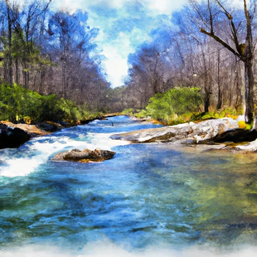
Headwaters In Standing Indian Basin To Slackwater Of Natahala Lake
Some of the specific rapids and obstacles on this run include the S-Turn rapid, the Corkscrew rapid, the Brainard's Bridge rapid, and the Final Curtain rapid. These rapids can be challenging, with steep drops, tight turns, and powerful currents. Participants should have proper gear, experience, and knowledge of the area before attempting this run.
There are specific regulations and guidelines in place for this area to ensure the safety of all participants. These include wearing a personal flotation device (PFD) at all times, obeying all posted signs and warnings, and obtaining necessary permits and licenses before entering the area. Additionally, participants should practice Leave No Trace principles and respect the natural environment.
Plan your run down to the hour
Same weather feed Snoflo's iOS app uses -- updated continuously from NOAA / yr.no. Watch the precipitation column on the meteogram; rain ahead of a run typically lifts flows 12-48 hours later depending on the basin.
Next 5 days, hour by hour
Temperature line with weather symbols on top, snow + rain accumulation as columns, humidity as a dotted line.
5-day forecast table
Every 3 hours, broken out across temperature, snow, rain, humidity, and wind. Each cell is colour-coded relative to the column min/max.
| Time | Condition | Temp (°F) | Snow (in) | Rain (in) | Humidity (%) | Wind (mps) | Wind dir |
|---|---|---|---|---|---|---|---|
| Loading detailed forecast… | |||||||
15-day temperature & precipitation
Daily temperatures, snow, and rain projected over the next two weeks -- the upstream story that drives next week's flows.
Regional streamflow levels
USGS streamgauges around Headwaters In Standing Indian Basin To Slackwater Of Natahala Lake -- useful for spotting upstream pulses and gauging which tributary is contributing what.
| Streamgauge | Discharge | View |
|---|---|---|
| Nantahala River Near Rainbow Springs | 166 cfs | → |
| Cartoogechaye Creek Near Franklin | 261 cfs | → |
| Little Tennessee River Near Prentiss | 159 cfs | → |
| Little Tennessee River At Needmore | 498 cfs | → |
| Little Tennessee R At Franklin | 1,050 cfs | → |
| Tallulah River Near Clayton | 103 cfs | → |
Plan a longer trip
The closest boat launches, other paddle runs, and campgrounds so a day on the water can grow into a full weekend.
Boat launches
Other river runs
- Natahala Powerhouse To Lake Fontana (River Mile 4)
- Polecat Branch To Snowbird Picnic Area
- Owlcamp Branch To Polecat Branch
- Headwaters Near Mitchell Lick To Owlcamp Branch
- Source Near Chattahoochee Gap To Mark Trail Wilderness Boundary
Campgrounds
- Wine Springs Horse Camp
- Wine Spring Campsite
- Moore Creek Camp
- Appletree Group Campground
- Appletree Group Camp
- Standing Indian Campground Store
Whitewater safety
- Check the flow before you run
- Use the linked-gauge card and Regional Flow panel above. Class ratings change with flow -- a Class III at low water can become Class IV+ at high water.
- Know your skill ceiling
- Pick runs comfortably below your ceiling. Cold-water and big-water runs raise the consequences of any mistake.
- Wear the right gear
- Helmet, PFD, drysuit / wetsuit when water is below 60°F. Throw bag, knife, and whistle on your person, not in the boat.
- Scout, set safety, and run with a team
- Scout new rapids on foot, set safety with throw bags above the consequence pool, and run with at least one other competent paddler.
- Respect the river
- Strainers, undercuts, low-head dams, and wood can kill at any class rating. When in doubt, portage.
Set push alerts in the Snoflo app
Save Headwaters In Standing Indian Basin To Slackwater Of Natahala Lake as a favorite, set a discharge threshold (e.g. "alert me when flow hits 600 cfs"), and the iOS app pushes the moment the linked gauge crosses.
About Headwaters In Standing Indian Basin To Slackwater Of Natahala Lake
What's the optimal flow for Headwaters In Standing Indian Basin To Slackwater Of Natahala Lake?
The optimal flow depends on the section and the craft. Check the Run Details panel for the linked gauge and current status.
How fresh is the cfs reading on this page?
The linked USGS streamgauge reports continuously (every 15 minutes); Snoflo refreshes throughout the day. Hover the streamflow sparkline to read individual datapoints.
What's the whitewater class?
See the Run Details panel for the class rating Snoflo tracks for this run. Class ratings change with flow -- a Class III at low water can become Class IV in high water.
Where do I put in / take out?
Tap Directions in the hero above to open driving directions to the put-in. For shuttle planning, check the Nearby Boat Launches panel and the river run operator's site.
Can I get alerts when flows hit the optimal range?
Yes -- alerts are managed in the Snoflo iOS app. Favorite this run, set a discharge threshold, and you'll get a push the moment the gauge crosses.
Other runs near here
Snoflo-tracked paddle runs within driving distance of Headwaters In Standing Indian Basin To Slackwater Of Natahala Lake.