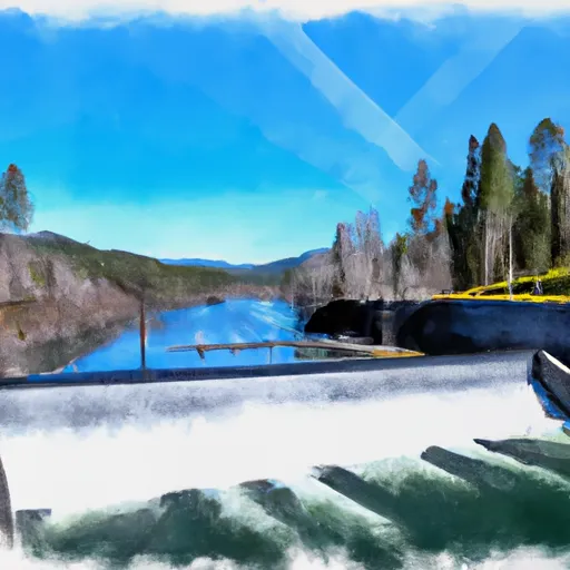
Timothy Lake Dam To Slackwater Of Harriet Lake River Run
Community Reviews
Been here? Share the conditions.
Reviews, ratings & photos are added in the free Snoflo iOS app — rate a spot, tag the conditions, and your visit is verified by location. Add or manage your reviews from the app.
Timothy Lake Dam To Slackwater Of Harriet Lake
The class rating for this run is Class III, with some sections approaching Class IV. The run covers a distance of approximately 7 miles and features several significant rapids and obstacles. Notable rapids include the Toilet Bowl, which requires precise navigation to avoid being caught in a whirlpool, and the Pinball Rapid, which features several large boulders that create challenging whitewater.
There are specific regulations in place for this area. All boaters are required to obtain a permit from the Forest Service before entering the river. Motorized boats are not allowed on this section of the river, and all boaters must wear a personal flotation device at all times.
Overall, the Whitewater River run from Timothy Lake Dam to Slackwater of Harriet Lake is a challenging and exciting destination for experienced whitewater paddlers. It is essential to check the current streamflow and weather conditions before heading out, as water levels can change rapidly.
Plan your run down to the hour
Same weather feed Snoflo's iOS app uses -- updated continuously from NOAA / yr.no. Watch the precipitation column on the meteogram; rain ahead of a run typically lifts flows 12-48 hours later depending on the basin.
Next 5 days, hour by hour
Temperature line with weather symbols on top, snow + rain accumulation as columns, humidity as a dotted line.
5-day forecast table
Every 3 hours, broken out across temperature, snow, rain, humidity, and wind. Each cell is colour-coded relative to the column min/max.
| Time | Condition | Temp (°F) | Snow (in) | Rain (in) | Humidity (%) | Wind (mps) | Wind dir |
|---|---|---|---|---|---|---|---|
| Loading detailed forecast… | |||||||
15-day temperature & precipitation
Daily temperatures, snow, and rain projected over the next two weeks -- the upstream story that drives next week's flows.
Regional streamflow levels
USGS streamgauges around Timothy Lake Dam To Slackwater Of Harriet Lake -- useful for spotting upstream pulses and gauging which tributary is contributing what.
| Streamgauge | Discharge | View |
|---|---|---|
| Oak Grove Fork Above Powerplant Intake | 256 cfs | → |
| Oak Grove Fork At Ripplebrook Campground | 109 cfs | → |
| Clackamas River Above Three Lynx Creek | 593 cfs | → |
| Oak Grove Fork Near Government Camp | 53 cfs | → |
| Bull Creek Near Wilhoit | 0 cfs | → |
| Breitenbush R Abv French Cr Nr Detroit | 116 cfs | → |
Plan a longer trip
The closest boat launches, other paddle runs, and campgrounds so a day on the water can grow into a full weekend.
Boat launches
- Harriet Lake
- Sandstone Bridge Boat Access Day Use
- Pine Point Campground
- Hoodview Campground
- Gone Creek Campground
- Oak Fork Campground
Other river runs
- North Fork Clackamas River
- Salmon River Canyon (Split Falls To Road Access)
- Welches Run
- Headwaters To North Section Line Of Sec 17, T4s, R5e
- North Section Line Of Sec 17, T4s, R5e To Slackwater North Fork Reservoir
Campgrounds
- Lake Harriet Campground/Day Use
- Shellrock Creek Campground
- Hideaway Lake Campground
- Ripplebrook Campground
- Rainbow Campground
- Buck Lake Camping
Whitewater safety
- Check the flow before you run
- Use the linked-gauge card and Regional Flow panel above. Class ratings change with flow -- a Class III at low water can become Class IV+ at high water.
- Know your skill ceiling
- Pick runs comfortably below your ceiling. Cold-water and big-water runs raise the consequences of any mistake.
- Wear the right gear
- Helmet, PFD, drysuit / wetsuit when water is below 60°F. Throw bag, knife, and whistle on your person, not in the boat.
- Scout, set safety, and run with a team
- Scout new rapids on foot, set safety with throw bags above the consequence pool, and run with at least one other competent paddler.
- Respect the river
- Strainers, undercuts, low-head dams, and wood can kill at any class rating. When in doubt, portage.
Set push alerts in the Snoflo app
Save Timothy Lake Dam To Slackwater Of Harriet Lake as a favorite, set a discharge threshold (e.g. "alert me when flow hits 600 cfs"), and the iOS app pushes the moment the linked gauge crosses.
About Timothy Lake Dam To Slackwater Of Harriet Lake
What's the optimal flow for Timothy Lake Dam To Slackwater Of Harriet Lake?
The optimal flow depends on the section and the craft. Check the Run Details panel for the linked gauge and current status.
How fresh is the cfs reading on this page?
The linked USGS streamgauge reports continuously (every 15 minutes); Snoflo refreshes throughout the day. Hover the streamflow sparkline to read individual datapoints.
What's the whitewater class?
See the Run Details panel for the class rating Snoflo tracks for this run. Class ratings change with flow -- a Class III at low water can become Class IV in high water.
Where do I put in / take out?
Tap Directions in the hero above to open driving directions to the put-in. For shuttle planning, check the Nearby Boat Launches panel and the river run operator's site.
Can I get alerts when flows hit the optimal range?
Yes -- alerts are managed in the Snoflo iOS app. Favorite this run, set a discharge threshold, and you'll get a push the moment the gauge crosses.
Other runs near here
Snoflo-tracked paddle runs within driving distance of Timothy Lake Dam To Slackwater Of Harriet Lake.