Little Luckiamute River River Run
Community Reviews
Been here? Share the conditions.
Reviews, ratings & photos are added in the free Snoflo iOS app — rate a spot, tag the conditions, and your visit is verified by location. Add or manage your reviews from the app.
Little Luckiamute River
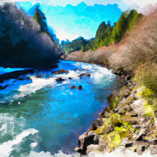
One of the most notable rapids on the Little Luckiamute River is "The Notch," which is a class III rapid that requires precise maneuvering. Other rapids on the river include "The Slot," "The Screaming Right," and "The Big Bend."
It is important to note that there are specific regulations in place for the Little Luckiamute River. The river is closed to all boating activities from July 16 to September 15 due to a critical fish habitat. Additionally, all boaters must carry a Type III or V personal flotation device and are required to follow all Oregon State Parks boating regulations.
In conclusion, the Little Luckiamute River is a must-visit destination for whitewater enthusiasts. With its ideal streamflow range, class II to III rating, specific river rapids and obstacles, and necessary regulations, this river offers an exciting and safe whitewater adventure.
Plan your run down to the hour
Same weather feed Snoflo's iOS app uses -- updated continuously from NOAA / yr.no. Watch the precipitation column on the meteogram; rain ahead of a run typically lifts flows 12-48 hours later depending on the basin.
Next 5 days, hour by hour
Temperature line with weather symbols on top, snow + rain accumulation as columns, humidity as a dotted line.
5-day forecast table
Every 3 hours, broken out across temperature, snow, rain, humidity, and wind. Each cell is colour-coded relative to the column min/max.
| Time | Condition | Temp (°F) | Snow (in) | Rain (in) | Humidity (%) | Wind (mps) | Wind dir |
|---|---|---|---|---|---|---|---|
| Loading detailed forecast… | |||||||
15-day temperature & precipitation
Daily temperatures, snow, and rain projected over the next two weeks -- the upstream story that drives next week's flows.
Regional streamflow levels
USGS streamgauges around Little Luckiamute River -- useful for spotting upstream pulses and gauging which tributary is contributing what.
| Streamgauge | Discharge | View |
|---|---|---|
| Siletz River At Siletz | 83 cfs | → |
| Luckiamute River Near Suver | 42 cfs | → |
| Willamette River At Corvallis | 3,980 cfs | → |
| Marys River Near Philomath | 12 cfs | → |
| Nestucca River Near Beaver | 103 cfs | → |
| Willamette River At Salem | 5,650 cfs | → |
Plan a longer trip
The closest boat launches, other paddle runs, and campgrounds so a day on the water can grow into a full weekend.
Boat launches
- Moonshine Park
- Ichwhit Park
- Twin Bridges Memorial Park
- Morgan Park
- Sunset Landing Rv Park & Campground
- Ojalla Bridge Slide
Other river runs
- Siletz River
- North Fork Siletz River
- Luckiamute River
- Yaquina River
- Upstream Crossing Of Eastern Siuslaw Nf Boundary To Confluence With Sampson Creek
Whitewater safety
- Check the flow before you run
- Use the linked-gauge card and Regional Flow panel above. Class ratings change with flow -- a Class III at low water can become Class IV+ at high water.
- Know your skill ceiling
- Pick runs comfortably below your ceiling. Cold-water and big-water runs raise the consequences of any mistake.
- Wear the right gear
- Helmet, PFD, drysuit / wetsuit when water is below 60°F. Throw bag, knife, and whistle on your person, not in the boat.
- Scout, set safety, and run with a team
- Scout new rapids on foot, set safety with throw bags above the consequence pool, and run with at least one other competent paddler.
- Respect the river
- Strainers, undercuts, low-head dams, and wood can kill at any class rating. When in doubt, portage.
Set push alerts in the Snoflo app
Save Little Luckiamute River as a favorite, set a discharge threshold (e.g. "alert me when flow hits 600 cfs"), and the iOS app pushes the moment the linked gauge crosses.
About Little Luckiamute River
What's the optimal flow for Little Luckiamute River?
The optimal flow depends on the section and the craft. Check the Run Details panel for the linked gauge and current status.
How fresh is the cfs reading on this page?
The linked USGS streamgauge reports continuously (every 15 minutes); Snoflo refreshes throughout the day. Hover the streamflow sparkline to read individual datapoints.
What's the whitewater class?
See the Run Details panel for the class rating Snoflo tracks for this run. Class ratings change with flow -- a Class III at low water can become Class IV in high water.
Where do I put in / take out?
Tap Directions in the hero above to open driving directions to the put-in. For shuttle planning, check the Nearby Boat Launches panel and the river run operator's site.
Can I get alerts when flows hit the optimal range?
Yes -- alerts are managed in the Snoflo iOS app. Favorite this run, set a discharge threshold, and you'll get a push the moment the gauge crosses.
Other runs near here
Snoflo-tracked paddle runs within driving distance of Little Luckiamute River.