Mccoy Creek River Run
Community Reviews
Been here? Share the conditions.
Reviews, ratings & photos are added in the free Snoflo iOS app — rate a spot, tag the conditions, and your visit is verified by location. Add or manage your reviews from the app.
Mccoy Creek
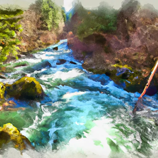
The river features multiple rapids and obstacles which require technical paddling skills to navigate safely. Some of the notable rapids in McCoy Creek include the Entrance Rapid, Boulder Drop, and S-Bend. These rapids offer a mixture of steep drops, technical maneuvers, and tight chutes that require precise boat handling to avoid obstacles and safely navigate through the rapids.
There are specific regulations set in place for the McCoy Creek river run. All participants are required to wear personal flotation devices (PFDs) and helmets, and it is recommended that paddlers carry a safety rope and a first-aid kit. Additionally, the use of alcohol or drugs is strictly prohibited, and camping is not allowed in the area.
In conclusion, McCoy Creek is a challenging river run that offers a thrilling experience for experienced paddlers. Its ideal streamflow range, class rating, segment mileage, and specific rapids/obstacles make it a popular destination for whitewater enthusiasts. However, it is important to follow the specific regulations set in place to ensure safety while paddling in this area.
Plan your run down to the hour
Same weather feed Snoflo's iOS app uses -- updated continuously from NOAA / yr.no. Watch the precipitation column on the meteogram; rain ahead of a run typically lifts flows 12-48 hours later depending on the basin.
Next 5 days, hour by hour
Temperature line with weather symbols on top, snow + rain accumulation as columns, humidity as a dotted line.
5-day forecast table
Every 3 hours, broken out across temperature, snow, rain, humidity, and wind. Each cell is colour-coded relative to the column min/max.
| Time | Condition | Temp (°F) | Snow (in) | Rain (in) | Humidity (%) | Wind (mps) | Wind dir |
|---|---|---|---|---|---|---|---|
| Loading detailed forecast… | |||||||
15-day temperature & precipitation
Daily temperatures, snow, and rain projected over the next two weeks -- the upstream story that drives next week's flows.
Regional streamflow levels
USGS streamgauges around Mccoy Creek -- useful for spotting upstream pulses and gauging which tributary is contributing what.
| Streamgauge | Discharge | View |
|---|---|---|
| Donner Und Blitzen River Nr Frenchglen Or | 35 cfs | → |
| Malheur R Be Warmsprings Res Nr Riverside Or | 0 cfs | → |
| Owyhee River Nr Rome Or | 75 cfs | → |
| North Fork Malheur River At Beulah Or | 1 cfs | → |
| Mcdermitt C Nr Mcdermitt Nv | 1 cfs | → |
| Owyhee River Below Owyhee Dam Or | 120 cfs | → |
Plan a longer trip
The closest boat launches, other paddle runs, and campgrounds so a day on the water can grow into a full weekend.
Boat launches
Campgrounds
- Steens Mountain Resort
- Lily Lake Campsite
- Page Springs Campground
- Page Springs Campsite
- Page Springs
- Ki6-User Created
Whitewater safety
- Check the flow before you run
- Use the linked-gauge card and Regional Flow panel above. Class ratings change with flow -- a Class III at low water can become Class IV+ at high water.
- Know your skill ceiling
- Pick runs comfortably below your ceiling. Cold-water and big-water runs raise the consequences of any mistake.
- Wear the right gear
- Helmet, PFD, drysuit / wetsuit when water is below 60°F. Throw bag, knife, and whistle on your person, not in the boat.
- Scout, set safety, and run with a team
- Scout new rapids on foot, set safety with throw bags above the consequence pool, and run with at least one other competent paddler.
- Respect the river
- Strainers, undercuts, low-head dams, and wood can kill at any class rating. When in doubt, portage.
Set push alerts in the Snoflo app
Save Mccoy Creek as a favorite, set a discharge threshold (e.g. "alert me when flow hits 600 cfs"), and the iOS app pushes the moment the linked gauge crosses.
About Mccoy Creek
What's the optimal flow for Mccoy Creek?
The optimal flow depends on the section and the craft. Check the Run Details panel for the linked gauge and current status.
How fresh is the cfs reading on this page?
The linked USGS streamgauge reports continuously (every 15 minutes); Snoflo refreshes throughout the day. Hover the streamflow sparkline to read individual datapoints.
What's the whitewater class?
See the Run Details panel for the class rating Snoflo tracks for this run. Class ratings change with flow -- a Class III at low water can become Class IV in high water.
Where do I put in / take out?
Tap Directions in the hero above to open driving directions to the put-in. For shuttle planning, check the Nearby Boat Launches panel and the river run operator's site.
Can I get alerts when flows hit the optimal range?
Yes -- alerts are managed in the Snoflo iOS app. Favorite this run, set a discharge threshold, and you'll get a push the moment the gauge crosses.
Other runs near here
Snoflo-tracked paddle runs within driving distance of Mccoy Creek.