Boundary Of Glen Canyon National Recreation Area And Capital Reef National Park To Confluence With Colorado River River Run
Community Reviews
Been here? Share the conditions.
Reviews, ratings & photos are added in the free Snoflo iOS app — rate a spot, tag the conditions, and your visit is verified by location. Add or manage your reviews from the app.
Boundary Of Glen Canyon National Recreation Area And Capital Reef National Park To Confluence With Colorado River
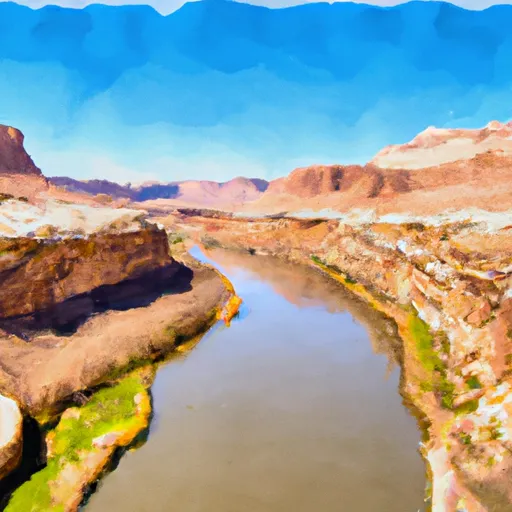
The segment mileage of the Whitewater River Run is approximately 20 miles, with specific river rapids and obstacles that provide exciting challenges for boaters. Some of the notable rapids include The Slide, The Gauntlet, Last Chance, and Satan's Gut. These rapids provide a thrilling experience for experienced boaters and require careful navigation.
There are specific regulations that must be followed when visiting this area. Permits are required for overnight camping and river access, and visitors must adhere to Leave No Trace principles to minimize their impact on the environment. Additionally, visitors should be aware of the potential hazards associated with whitewater boating, including swift currents, submerged rocks, and other obstacles.
In summary, the Whitewater River Run offers experienced boaters a thrilling whitewater experience in a stunning natural setting. With ideal streamflow ranges between 300 and 800 cfs, Class III-IV rapids, and specific regulations in place, visitors can enjoy a safe and exciting adventure on the river.
Plan your run down to the hour
Same weather feed Snoflo's iOS app uses -- updated continuously from NOAA / yr.no. Watch the precipitation column on the meteogram; rain ahead of a run typically lifts flows 12-48 hours later depending on the basin.
Next 5 days, hour by hour
Temperature line with weather symbols on top, snow + rain accumulation as columns, humidity as a dotted line.
5-day forecast table
Every 3 hours, broken out across temperature, snow, rain, humidity, and wind. Each cell is colour-coded relative to the column min/max.
| Time | Condition | Temp (°F) | Snow (in) | Rain (in) | Humidity (%) | Wind (mps) | Wind dir |
|---|---|---|---|---|---|---|---|
| Loading detailed forecast… | |||||||
15-day temperature & precipitation
Daily temperatures, snow, and rain projected over the next two weeks -- the upstream story that drives next week's flows.
Regional streamflow levels
USGS streamgauges around Boundary Of Glen Canyon National Recreation Area And Capital Reef National Park To Confluence With Colorado River -- useful for spotting upstream pulses and gauging which tributary is contributing what.
| Streamgauge | Discharge | View |
|---|---|---|
| Escalante River Near Escalante | 1 cfs | → |
| Dirty Devil R Abv Poison Sp Wash Nr Hanksville | 94 cfs | → |
| Pine Creek Near Escalante | 1 cfs | → |
| Fremont River Near Bicknell | 39 cfs | → |
| San Juan River Near Bluff | 763 cfs | → |
| Paria River At Lees Ferry | 75 cfs | → |
Plan a longer trip
The closest boat launches, other paddle runs, and campgrounds so a day on the water can grow into a full weekend.
Boat launches
Other river runs
- Stevens Canyon
- Headwaters At T38s, R9e To Confluence With Fence Canyon Creek
- Cow Canyon
- Georgies Canyon
Whitewater safety
- Check the flow before you run
- Use the linked-gauge card and Regional Flow panel above. Class ratings change with flow -- a Class III at low water can become Class IV+ at high water.
- Know your skill ceiling
- Pick runs comfortably below your ceiling. Cold-water and big-water runs raise the consequences of any mistake.
- Wear the right gear
- Helmet, PFD, drysuit / wetsuit when water is below 60°F. Throw bag, knife, and whistle on your person, not in the boat.
- Scout, set safety, and run with a team
- Scout new rapids on foot, set safety with throw bags above the consequence pool, and run with at least one other competent paddler.
- Respect the river
- Strainers, undercuts, low-head dams, and wood can kill at any class rating. When in doubt, portage.
Set push alerts in the Snoflo app
Save Boundary Of Glen Canyon National Recreation Area And Capital Reef National Park To Confluence With Colorado River as a favorite, set a discharge threshold (e.g. "alert me when flow hits 600 cfs"), and the iOS app pushes the moment the linked gauge crosses.
About Boundary Of Glen Canyon National Recreation Area And Capital Reef National Park To Confluence With Colorado River
What's the optimal flow for Boundary Of Glen Canyon National Recreation Area And Capital Reef National Park To Confluence With Colorado River?
The optimal flow depends on the section and the craft. Check the Run Details panel for the linked gauge and current status.
How fresh is the cfs reading on this page?
The linked USGS streamgauge reports continuously (every 15 minutes); Snoflo refreshes throughout the day. Hover the streamflow sparkline to read individual datapoints.
What's the whitewater class?
See the Run Details panel for the class rating Snoflo tracks for this run. Class ratings change with flow -- a Class III at low water can become Class IV in high water.
Where do I put in / take out?
Tap Directions in the hero above to open driving directions to the put-in. For shuttle planning, check the Nearby Boat Launches panel and the river run operator's site.
Can I get alerts when flows hit the optimal range?
Yes -- alerts are managed in the Snoflo iOS app. Favorite this run, set a discharge threshold, and you'll get a push the moment the gauge crosses.
Other runs near here
Snoflo-tracked paddle runs within driving distance of Boundary Of Glen Canyon National Recreation Area And Capital Reef National Park To Confluence With Colorado River.