Lower Boulder Creek river run
Community Reviews
Been here? Share the conditions.
Reviews, ratings & photos are added in the free Snoflo iOS app — rate a spot, tag the conditions, and your visit is verified by location. Add or manage your reviews from the app.
Lower Boulder Creek
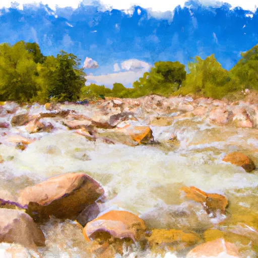
The ideal streamflow range for Lower Boulder Creek is between 200-500 cfs. When the water levels are lower, the river becomes more technical with tighter channels and boulder gardens, while higher water levels offer bigger waves and faster currents.
The specific river rapids and obstacles on Lower Boulder Creek include Boulder Falls, a Class IV rapid with a steep drop and a tight entrance. Another notable feature is the Narrows, a narrow canyon section with several rocky drops and chutes.
It's important to note that Lower Boulder Creek is managed by the Bureau of Land Management, and a permit is required for all boaters. The permit can be obtained online or at the BLM field office in Moab. Additionally, the use of glass containers and camping within 200 feet of the river is prohibited.
Overall, Lower Boulder Creek is an exciting and challenging river run for experienced kayakers, with specific regulations in place to ensure the safety and preservation of the area.
Plan your run down to the hour
Same weather feed Snoflo's iOS app uses -- updated continuously from NOAA / yr.no. Watch the precipitation column on the meteogram; rain ahead of a run typically lifts flows 12-48 hours later depending on the basin.
Next 5 days, hour by hour
Temperature line with weather symbols on top, snow + rain accumulation as columns, humidity as a dotted line.
5-day forecast table
Every 3 hours, broken out across temperature, snow, rain, humidity, and wind. Each cell is colour-coded relative to the column min/max.
| Time | Condition | Temp (°F) | Snow (in) | Rain (in) | Humidity (%) | Wind (mps) | Wind dir |
|---|---|---|---|---|---|---|---|
| Loading detailed forecast… | |||||||
15-day temperature & precipitation
Daily temperatures, snow, and rain projected over the next two weeks -- the upstream story that drives next week's flows.
Regional streamflow levels
USGS streamgauges around Lower Boulder Creek -- useful for spotting upstream pulses and gauging which tributary is contributing what.
| Streamgauge | Discharge | View |
|---|---|---|
| Escalante River Near Escalante | 0 cfs | → |
| Pine Creek Near Escalante | 0 cfs | → |
| Fremont River Near Bicknell | 45 cfs | → |
| East Fork Sevier River Near Kingston | 21 cfs | → |
| Sevier River Near Kingston | 1 cfs | → |
| Seven Mile Creek Near Fish Lake | 4 cfs | → |
Plan a longer trip
The closest boat launches, other paddle runs, and campgrounds so a day on the water can grow into a full weekend.
Campgrounds
- Durffey Mesa Dispersed - Burr Trail Rd - Grand Staircase Nat Mon
- Deer Creek- Burr Trail Rd - Grand Staircase Nat Mon
- Steep Creek Bench - Burr Trail Rd - Grand Staircase Nat Mon
- Calf Creek Recreation Area
- Calf Creek
- Little Spencer Flat Dispersed - Grand Staircase Nat Mon
Fishing spots
Whitewater safety
- Check the flow before you run
- Use the linked-gauge card and Regional Flow panel above. Class ratings change with flow -- a Class III at low water can become Class IV+ at high water.
- Know your skill ceiling
- Pick runs comfortably below your ceiling. Cold-water and big-water runs raise the consequences of any mistake.
- Wear the right gear
- Helmet, PFD, drysuit / wetsuit when water is below 60°F. Throw bag, knife, and whistle on your person, not in the boat.
- Scout, set safety, and run with a team
- Scout new rapids on foot, set safety with throw bags above the consequence pool, and run with at least one other competent paddler.
- Respect the river
- Strainers, undercuts, low-head dams, and wood can kill at any class rating. When in doubt, portage.
Set push alerts in the Snoflo app
Save Lower Boulder Creek as a favorite, set a discharge threshold (e.g. "alert me when flow hits 600 cfs"), and the iOS app pushes the moment the linked gauge crosses.
About Lower Boulder Creek
What's the optimal flow for Lower Boulder Creek?
The optimal flow depends on the section and the craft. Check the Run Details panel for the linked gauge and current status.
How fresh is the cfs reading on this page?
The linked USGS streamgauge reports continuously (every 15 minutes); Snoflo refreshes throughout the day. Hover the streamflow sparkline to read individual datapoints.
What's the whitewater class?
See the Run Details panel for the class rating Snoflo tracks for this run. Class ratings change with flow -- a Class III at low water can become Class IV in high water.
Where do I put in / take out?
Tap Directions in the hero above to open driving directions to the put-in. For shuttle planning, check the Nearby Boat Launches panel and the river run operator's site.
Can I get alerts when flows hit the optimal range?
Yes -- alerts are managed in the Snoflo iOS app. Favorite this run, set a discharge threshold, and you'll get a push the moment the gauge crosses.
Other runs near here
Snoflo-tracked paddle runs within driving distance of Lower Boulder Creek.