Lower Paria River River Run
Community Reviews
Been here? Share the conditions.
Reviews, ratings & photos are added in the free Snoflo iOS app — rate a spot, tag the conditions, and your visit is verified by location. Add or manage your reviews from the app.
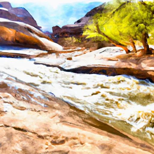
Lower Paria River
The Lower Paria River is rated as a Class III to IV, with technical rapids and obstacles that require advanced skills and experience. The segment mileage for this run is approximately 38 miles, and the river features several notable rapids, including the popular "Mile Long Rapid," which is a Class IV rapid that spans over a mile in length.
Boaters should be aware of specific regulations in the area, including the requirement to obtain a permit from the Bureau of Land Management (BLM) before entering the Lower Paria River. Additionally, there are restrictions on camping and fire use along the river to protect the fragile desert environment.
Overall, the Lower Paria River is a challenging and scenic river run that requires advanced skills and experience to navigate safely. Boaters should always be aware of streamflow levels and regulations in the area to ensure a safe and enjoyable trip.
Plan your run down to the hour
Same weather feed Snoflo's iOS app uses -- updated continuously from NOAA / yr.no. Watch the precipitation column on the meteogram; rain ahead of a run typically lifts flows 12-48 hours later depending on the basin.
Next 5 days, hour by hour
Temperature line with weather symbols on top, snow + rain accumulation as columns, humidity as a dotted line.
5-day forecast table
Every 3 hours, broken out across temperature, snow, rain, humidity, and wind. Each cell is colour-coded relative to the column min/max.
| Time | Condition | Temp (°F) | Snow (in) | Rain (in) | Humidity (%) | Wind (mps) | Wind dir |
|---|---|---|---|---|---|---|---|
| Loading detailed forecast… | |||||||
15-day temperature & precipitation
Daily temperatures, snow, and rain projected over the next two weeks -- the upstream story that drives next week's flows.
Regional streamflow levels
USGS streamgauges around Lower Paria River -- useful for spotting upstream pulses and gauging which tributary is contributing what.
| Streamgauge | Discharge | View |
|---|---|---|
| Paria River Near Kanab | 1 cfs | → |
| Paria River At Lees Ferry | 3 cfs | → |
| Colorado River At Lees Ferry | 8,990 cfs | → |
| Kanab Creek Near Kanab | 3 cfs | → |
| East Fork Virgin River Near Glendale | 4 cfs | → |
| Sevier River At Hatch | 40 cfs | → |
Plan a longer trip
The closest boat launches, other paddle runs, and campgrounds so a day on the water can grow into a full weekend.
Campgrounds
- Bridger Point Camping Allowed
- White House Trailhead - Paria Canyon - Grand Staircase Nat Mon
- White House Campground
- Camping Judd Hollow
- Buckskin Gulch - House Rock Valley
- State Line - House Rock Valley
Parks
- Paria Canyon-Vermilion Cliffs Wilderness
- Grand Staircase Escalante National Monument
- Glen Canyon National Recreation Area
Points of interest
Whitewater safety
- Check the flow before you run
- Use the linked-gauge card and Regional Flow panel above. Class ratings change with flow -- a Class III at low water can become Class IV+ at high water.
- Know your skill ceiling
- Pick runs comfortably below your ceiling. Cold-water and big-water runs raise the consequences of any mistake.
- Wear the right gear
- Helmet, PFD, drysuit / wetsuit when water is below 60°F. Throw bag, knife, and whistle on your person, not in the boat.
- Scout, set safety, and run with a team
- Scout new rapids on foot, set safety with throw bags above the consequence pool, and run with at least one other competent paddler.
- Respect the river
- Strainers, undercuts, low-head dams, and wood can kill at any class rating. When in doubt, portage.
Set push alerts in the Snoflo app
Save Lower Paria River as a favorite, set a discharge threshold (e.g. "alert me when flow hits 600 cfs"), and the iOS app pushes the moment the linked gauge crosses.
About Lower Paria River
What's the optimal flow for Lower Paria River?
The optimal flow depends on the section and the craft. Check the Run Details panel for the linked gauge and current status.
How fresh is the cfs reading on this page?
The linked USGS streamgauge reports continuously (every 15 minutes); Snoflo refreshes throughout the day. Hover the streamflow sparkline to read individual datapoints.
What's the whitewater class?
See the Run Details panel for the class rating Snoflo tracks for this run. Class ratings change with flow -- a Class III at low water can become Class IV in high water.
Where do I put in / take out?
Tap Directions in the hero above to open driving directions to the put-in. For shuttle planning, check the Nearby Boat Launches panel and the river run operator's site.
Can I get alerts when flows hit the optimal range?
Yes -- alerts are managed in the Snoflo iOS app. Favorite this run, set a discharge threshold, and you'll get a push the moment the gauge crosses.
Other runs near here
Snoflo-tracked paddle runs within driving distance of Lower Paria River.