San Rafael River river run
Community Reviews
Been here? Share the conditions.
Reviews, ratings & photos are added in the free Snoflo iOS app — rate a spot, tag the conditions, and your visit is verified by location. Add or manage your reviews from the app.
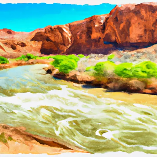
San Rafael River
As with all river runs, it is important to be aware of any specific regulations in the area. The San Rafael River is located in the San Rafael Swell, which is managed by the Bureau of Land Management (BLM). The BLM requires that all boaters obtain a permit before embarking on a river trip and follow Leave No Trace principles to minimize their impact on the environment. Additionally, the BLM prohibits motorized watercraft on the San Rafael River, making it a peaceful and quiet trip for non-motorized watercraft.
In conclusion, the San Rafael River in Utah offers an exhilarating whitewater experience for experienced rafters. With an ideal streamflow range between 300-600 cfs, a Class III-IV rating, and numerous rapids and obstacles, the Buckhorn Wash to Fuller Bottom stretch is a popular destination. It is important to obtain a permit from the BLM and follow Leave No Trace principles to protect the environment and maintain the natural beauty of the area.
Plan your run down to the hour
Same weather feed Snoflo's iOS app uses -- updated continuously from NOAA / yr.no. Watch the precipitation column on the meteogram; rain ahead of a run typically lifts flows 12-48 hours later depending on the basin.
Next 5 days, hour by hour
Temperature line with weather symbols on top, snow + rain accumulation as columns, humidity as a dotted line.
5-day forecast table
Every 3 hours, broken out across temperature, snow, rain, humidity, and wind. Each cell is colour-coded relative to the column min/max.
| Time | Condition | Temp (°F) | Snow (in) | Rain (in) | Humidity (%) | Wind (mps) | Wind dir |
|---|---|---|---|---|---|---|---|
| Loading detailed forecast… | |||||||
15-day temperature & precipitation
Daily temperatures, snow, and rain projected over the next two weeks -- the upstream story that drives next week's flows.
Regional streamflow levels
USGS streamgauges around San Rafael River -- useful for spotting upstream pulses and gauging which tributary is contributing what.
| Streamgauge | Discharge | View |
|---|---|---|
| Ferron Cr Bl Millsite Res & Divs Nr Ferron | · | → |
| Ferron Creek (Upper Station) Near Ferron | 9 cfs | → |
| Muddy Creek Near Emery | 9 cfs | → |
| Desert Seep Wash Near Wellington | 2 cfs | → |
| Price River At Woodside | · | → |
| San Rafael River Near Green River | · | → |
Plan a longer trip
The closest boat launches, other paddle runs, and campgrounds so a day on the water can grow into a full weekend.
Boat launches
Campgrounds
- The Wedge Camping Area
- Wedge Overlook
- Buckhorn Draw Camping Area
- Swinging Bridge South Campground
- Swinging Bridge North Campground
- San Rafael Bridge
Whitewater safety
- Check the flow before you run
- Use the linked-gauge card and Regional Flow panel above. Class ratings change with flow -- a Class III at low water can become Class IV+ at high water.
- Know your skill ceiling
- Pick runs comfortably below your ceiling. Cold-water and big-water runs raise the consequences of any mistake.
- Wear the right gear
- Helmet, PFD, drysuit / wetsuit when water is below 60°F. Throw bag, knife, and whistle on your person, not in the boat.
- Scout, set safety, and run with a team
- Scout new rapids on foot, set safety with throw bags above the consequence pool, and run with at least one other competent paddler.
- Respect the river
- Strainers, undercuts, low-head dams, and wood can kill at any class rating. When in doubt, portage.
Set push alerts in the Snoflo app
Save San Rafael River as a favorite, set a discharge threshold (e.g. "alert me when flow hits 600 cfs"), and the iOS app pushes the moment the linked gauge crosses.
About San Rafael River
What's the optimal flow for San Rafael River?
The optimal flow depends on the section and the craft. Check the Run Details panel for the linked gauge and current status.
How fresh is the cfs reading on this page?
The linked USGS streamgauge reports continuously (every 15 minutes); Snoflo refreshes throughout the day. Hover the streamflow sparkline to read individual datapoints.
What's the whitewater class?
See the Run Details panel for the class rating Snoflo tracks for this run. Class ratings change with flow -- a Class III at low water can become Class IV in high water.
Where do I put in / take out?
Tap Directions in the hero above to open driving directions to the put-in. For shuttle planning, check the Nearby Boat Launches panel and the river run operator's site.
Can I get alerts when flows hit the optimal range?
Yes -- alerts are managed in the Snoflo iOS app. Favorite this run, set a discharge threshold, and you'll get a push the moment the gauge crosses.
Other runs near here
Snoflo-tracked paddle runs within driving distance of San Rafael River.