Dolores River Segment 3 River Run
Community Reviews
Been here? Share the conditions.
Reviews, ratings & photos are added in the free Snoflo iOS app — rate a spot, tag the conditions, and your visit is verified by location. Add or manage your reviews from the app.
Dolores River Segment 3
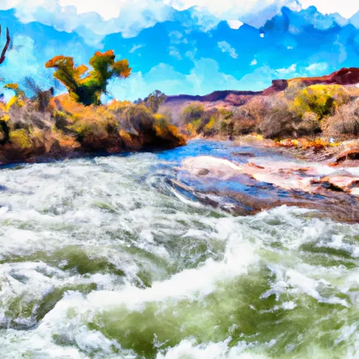
This segment is known for its stunning scenery, including towering sandstone cliffs and lush vegetation. The specific rapids and obstacles on this segment include Snaggletooth, Stateline Falls, and Slickrock Canyon. These rapids require experienced paddlers to navigate safely and are not recommended for beginners.
There are specific regulations in place for the Dolores River Segment 3. All boaters must obtain a permit from the Bureau of Land Management, and there is a limit on the number of permits issued each year. Additionally, all boaters must follow Leave No Trace principles and pack out all waste.
In conclusion, the Dolores River Segment 3 is a challenging and scenic whitewater river run in Southeast Utah. Paddlers should be experienced and prepared for technical maneuvers and challenging rapids. Obtaining a permit and following regulations is important to protect the area and preserve the natural beauty of the river.
Plan your run down to the hour
Same weather feed Snoflo's iOS app uses -- updated continuously from NOAA / yr.no. Watch the precipitation column on the meteogram; rain ahead of a run typically lifts flows 12-48 hours later depending on the basin.
Next 5 days, hour by hour
Temperature line with weather symbols on top, snow + rain accumulation as columns, humidity as a dotted line.
5-day forecast table
Every 3 hours, broken out across temperature, snow, rain, humidity, and wind. Each cell is colour-coded relative to the column min/max.
| Time | Condition | Temp (°F) | Snow (in) | Rain (in) | Humidity (%) | Wind (mps) | Wind dir |
|---|---|---|---|---|---|---|---|
| Loading detailed forecast… | |||||||
15-day temperature & precipitation
Daily temperatures, snow, and rain projected over the next two weeks -- the upstream story that drives next week's flows.
Regional streamflow levels
USGS streamgauges around Dolores River Segment 3 -- useful for spotting upstream pulses and gauging which tributary is contributing what.
| Streamgauge | Discharge | View |
|---|---|---|
| Colorado River Near Cisco | 1,820 cfs | → |
| Dolores River Near Cisco | 98 cfs | → |
| Castle Creek Below Castle Valley Near Moab | 4 cfs | → |
| Dolores River Near Gateway | 57 cfs | → |
| Mill Creek Blw Pack Creek Nr Mouth At Moab | 0 cfs | → |
| Mill Creek Below Sheley Tunnel | 3 cfs | → |
Plan a longer trip
The closest boat launches, other paddle runs, and campgrounds so a day on the water can grow into a full weekend.
Boat launches
- Dewey Bridge Recreation Site
- Grand County
- Hittle Bottom Recreation Site
- Ut 128 Moab
- Lower Onion Creek Boat Ramp
- Fisher Towers Road Grand County
Other river runs
- Colorado River Segment 3b
- Colorado River Segment 4
- Colorado River Segment 3a
- Moab Daily - Hittle Bottom To Take Out Beach
- Hittle Bottom To Rocky Rapid
Campgrounds
Fishing spots
Points of interest
Whitewater safety
- Check the flow before you run
- Use the linked-gauge card and Regional Flow panel above. Class ratings change with flow -- a Class III at low water can become Class IV+ at high water.
- Know your skill ceiling
- Pick runs comfortably below your ceiling. Cold-water and big-water runs raise the consequences of any mistake.
- Wear the right gear
- Helmet, PFD, drysuit / wetsuit when water is below 60°F. Throw bag, knife, and whistle on your person, not in the boat.
- Scout, set safety, and run with a team
- Scout new rapids on foot, set safety with throw bags above the consequence pool, and run with at least one other competent paddler.
- Respect the river
- Strainers, undercuts, low-head dams, and wood can kill at any class rating. When in doubt, portage.
Set push alerts in the Snoflo app
Save Dolores River Segment 3 as a favorite, set a discharge threshold (e.g. "alert me when flow hits 600 cfs"), and the iOS app pushes the moment the linked gauge crosses.
About Dolores River Segment 3
What's the optimal flow for Dolores River Segment 3?
The optimal flow depends on the section and the craft. Check the Run Details panel for the linked gauge and current status.
How fresh is the cfs reading on this page?
The linked USGS streamgauge reports continuously (every 15 minutes); Snoflo refreshes throughout the day. Hover the streamflow sparkline to read individual datapoints.
What's the whitewater class?
See the Run Details panel for the class rating Snoflo tracks for this run. Class ratings change with flow -- a Class III at low water can become Class IV in high water.
Where do I put in / take out?
Tap Directions in the hero above to open driving directions to the put-in. For shuttle planning, check the Nearby Boat Launches panel and the river run operator's site.
Can I get alerts when flows hit the optimal range?
Yes -- alerts are managed in the Snoflo iOS app. Favorite this run, set a discharge threshold, and you'll get a push the moment the gauge crosses.
Other runs near here
Snoflo-tracked paddle runs within driving distance of Dolores River Segment 3.