Segment D--Gathright Dam To State Route 687 Bridge At Clearwater Park River Run
Community Reviews
Been here? Share the conditions.
Reviews, ratings & photos are added in the free Snoflo iOS app — rate a spot, tag the conditions, and your visit is verified by location. Add or manage your reviews from the app.
Segment D--Gathright Dam To State Route 687 Bridge At Clearwater Park
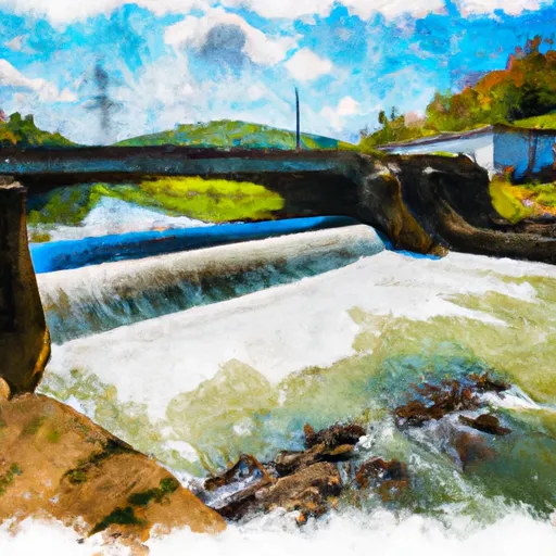
This segment is known for its scenic beauty and fun rapids, including the scenic Gathright Dam and the technical Class III rapids at the Cowpasture River Falls. Other notable rapids include Twin Falls, Devil's Kitchen, and Ledge Drop. However, caution should be taken during high water levels as the rapids can increase in difficulty.
There are specific regulations in place for this area, including a Virginia fishing license requirement for those who want to fish in the river. Additionally, there are specific regulations for camping and fires in the nearby George Washington and Jefferson National Forest.
Overall, the Cowpasture River's Segment D is a great option for intermediate paddlers looking for a fun and scenic whitewater experience. However, it is important to pay attention to water levels and regulations in order to ensure a safe and enjoyable trip.
Plan your run down to the hour
Same weather feed Snoflo's iOS app uses -- updated continuously from NOAA / yr.no. Watch the precipitation column on the meteogram; rain ahead of a run typically lifts flows 12-48 hours later depending on the basin.
Next 5 days, hour by hour
Temperature line with weather symbols on top, snow + rain accumulation as columns, humidity as a dotted line.
5-day forecast table
Every 3 hours, broken out across temperature, snow, rain, humidity, and wind. Each cell is colour-coded relative to the column min/max.
| Time | Condition | Temp (°F) | Snow (in) | Rain (in) | Humidity (%) | Wind (mps) | Wind dir |
|---|---|---|---|---|---|---|---|
| Loading detailed forecast… | |||||||
15-day temperature & precipitation
Daily temperatures, snow, and rain projected over the next two weeks -- the upstream story that drives next week's flows.
Regional streamflow levels
USGS streamgauges around Segment D--Gathright Dam To State Route 687 Bridge At Clearwater Park -- useful for spotting upstream pulses and gauging which tributary is contributing what.
| Streamgauge | Discharge | View |
|---|---|---|
| Jackson River Bl Dunlap Creek At Covington | 339 cfs | → |
| Dunlap Creek Near Covington | 41 cfs | → |
| Jackson River Bl Gathright Dam Nr Hot Spgs | 240 cfs | → |
| Potts Creek Near Covington | 58 cfs | → |
| James River At Lick Run | 507 cfs | → |
| Craig Creek At Parr | 69 cfs | → |
Plan a longer trip
The closest boat launches, other paddle runs, and campgrounds so a day on the water can grow into a full weekend.
Boat launches
- Petticoat Junction
- Indian Draft
- Johnson Spring
- Jackson River Canoe Access Points
- Lake Moomaw (Coles Point)
- Coles Point
Other river runs
- Segment A--Route 42 Bridge To Confluence With Jackson River
- Segment B--Confluence With Bullpasture River To Route 42 Bridge
- Segment A--State Route 39 At Blowing Springs Campground To Lake Moomaw
- Segment C--Southern Boundary Hidden Valley Tract To Mcclintic Bridge
- Segment B--Northern Boundary, Hidden Valley Tract To Southern Boundary Of Hidden Valley Tract
Campgrounds
- Morris Hill Campground
- Greenwood Point Campground
- Serenity
- Mcclintic Point Campground
- Bolar Mountain
- Bolar Mountain Campground
Whitewater safety
- Check the flow before you run
- Use the linked-gauge card and Regional Flow panel above. Class ratings change with flow -- a Class III at low water can become Class IV+ at high water.
- Know your skill ceiling
- Pick runs comfortably below your ceiling. Cold-water and big-water runs raise the consequences of any mistake.
- Wear the right gear
- Helmet, PFD, drysuit / wetsuit when water is below 60°F. Throw bag, knife, and whistle on your person, not in the boat.
- Scout, set safety, and run with a team
- Scout new rapids on foot, set safety with throw bags above the consequence pool, and run with at least one other competent paddler.
- Respect the river
- Strainers, undercuts, low-head dams, and wood can kill at any class rating. When in doubt, portage.
Set push alerts in the Snoflo app
Save Segment D--Gathright Dam To State Route 687 Bridge At Clearwater Park as a favorite, set a discharge threshold (e.g. "alert me when flow hits 600 cfs"), and the iOS app pushes the moment the linked gauge crosses.
About Segment D--Gathright Dam To State Route 687 Bridge At Clearwater Park
What's the optimal flow for Segment D--Gathright Dam To State Route 687 Bridge At Clearwater Park?
The optimal flow depends on the section and the craft. Check the Run Details panel for the linked gauge and current status.
How fresh is the cfs reading on this page?
The linked USGS streamgauge reports continuously (every 15 minutes); Snoflo refreshes throughout the day. Hover the streamflow sparkline to read individual datapoints.
What's the whitewater class?
See the Run Details panel for the class rating Snoflo tracks for this run. Class ratings change with flow -- a Class III at low water can become Class IV in high water.
Where do I put in / take out?
Tap Directions in the hero above to open driving directions to the put-in. For shuttle planning, check the Nearby Boat Launches panel and the river run operator's site.
Can I get alerts when flows hit the optimal range?
Yes -- alerts are managed in the Snoflo iOS app. Favorite this run, set a discharge threshold, and you'll get a push the moment the gauge crosses.
Other runs near here
Snoflo-tracked paddle runs within driving distance of Segment D--Gathright Dam To State Route 687 Bridge At Clearwater Park.